

Air Terjun Tujuh Puteri (Seven Princesses Waterfall) is a series of small waterfalls in Bukit Sri Permata hiking trails. There is a low peak on the hill of Bukit Sri Permata, while hikers who are looking for more could continue further to Bukit Madei peak.
While there are many alternative, interconnected trails along the way, hikers who want to head straight to the waterfall could do it fairly easily by following the signboards pointing to the waterfall on the main trail through Kampung Tauhid. For a loop track to the peak first and then the waterfalls, you may refer to this map I recorded on OutdoorActive:
Bukit Sri Permata & Air Terjun Tujuh Puteri Car Park & Trailhead


5.50am: This free trip was organized by Trailblazer Hiking Club Malaysia. We parked and gathered at the cemetery car park to start the hike early in the morning for sunrise.


(+35)6.20am: The hike to Bukit Sri Permata peak is short. There is a small ‘pondok’ (gazebo) at the hill peak.
Bukit Sri Permata Peak (300m)

City view from the peak before sunrise.


Day break.

6.55am: It was cloudy on the horizon. The sky brightened up before we could see the sun.

View of Bukit Tabur, maybe?

Some farms around the hills. You could buy fresh vegetables from the farmers as you head back to the car park.

7.38am: Finally, the sun rose up above the thick clouds. Accompanying the view was a sea of clouds in the distance.

7.49am: With the sun up, we continued our journey towards the waterfalls.

(+6)7.55am: We headed back down to the junction with a building (looks like a small ‘kedai makan’ or shop) and took the other way (from the way we came, left is to the peak and right is to the waterfall).

(+2)7.57am: Walk along Jalan Kosnin to the waterfalls.

(+16)8.13am: Our group decided to turn off at this unmarked trail (hence the weird-looking top section of the recorded map above). There are other actual trails available before and after this turnoff point, which should be much easier.


For the non-actual trail we took, we went ‘off’ a bit and took a little more time heading down steep and slippery sections. So, it’s better to stick to the visible trails marked on the map.
Air Terjun Tujuh Puteri

(+32)8.45am: Nevertheless, we arrived at the stream, which is at the top/upstream of the falls, and we will then hike downstream to pass the waterfalls.

(+5)8.50am: One of the first cascades along the way.


(+12)9.02am: The second cascade. Continue hiking downstream.

(+13)9.15am: Next few cascades.

(+3)9.18am

(+3)9.21am

(+3)9.24am


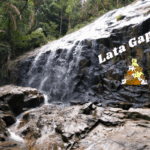
(+2)9.26am: Arrived at the signposted waterfall of Air Terjun Tujuh Puteri, the tallest/biggest one among the cascade, though it’s still pretty small.

(+17)9.43am: Another cascade further down the trail.

(+32)10.15am

(+4)10.19am

(+3)10.22am

(+1)10.23am

(+33)10.56am: Exited the trailhead with farms by the roadside.

After the hike, I went for a special Kelate brunch at Pokli Mee Celup in Batu Caves.
Check out Jaszmyn video of the same trip:
Have this guide helped you? Tag @meowtainpeople in your hiking stories & posts!

*Captain Planet passing by* Remember, please take care of our environment, and please don’t destroy the Nature. Leave no trash behind and take back only photos and memories (and also some trash if you can). Walk on the designated path and stay in the middle as much as you can, so that the exposed soil doesn’t spread/corrode further. BE ONE WITH NATURE *flies away*


Affiliate Links to support this site:
Yay for transparency!: The links above are affiliate links, and at no additional cost to you, I earn a commission if you make a booking/purchase after clicking the links. I recommend only products and companies I use. Your support helps me keep the site going 🙂
Want to do the same affiliate marketing with your site? Use this AccessTrade platform link to receive RM5 reward.
Do we require any permit?
No need permit for Air Terjun Tujuh Puteri / Bukit Sri Permata as far as I know, it is not under the list of forest reserve.