
Gunung Berembun in Negeri Sembilan is located in Berembun Forest Reserve close to the state capital Seremban. The hike is known for waterfalls, peaks, and the WWII bomber war plane wreckages at the crash site of Royal Air Force’s B-24 Liberator.
P.S. Not to be confused with Gunung Berembun in Cameron Highlands and Berembun Peak of Chemerong-Berembun-Langsir (CBL) in Dungun.


In the morning before our hike, we dropped by Nasi Lemak Ikan Sembilang Lenggeng for breakfast to try their special sambal ikan sembilang. Other than that, we bought some lepat pisang and other kiuh-muih to take with us for our hike.
Gunung Berembun Negeri Sembilan Trailhead & Permit

At first, our initial plan was to hike from Gunung Berembun to Gunung Telapak Buruk and exit via Dataran Bukit Tangga. However, we later found out the trail to Telapak Buruk has been closed since 2020 and so far there seems to be no plan to reopen it.

The hike starts from the back of the permit counter of Gunung Berembun. Permit (RM5 per person) is required and you can buy it on-the-spot from the counter (photo taken after the hike, hence the closed counter). You can also pre-purchase the permit online.

9.02am: Entrance of Gunung Berembun trailhead is up the stairs behind the permit counter.

Found some jungle chestnuts.

(+6)9.08am

(+4)9.12am


(+16)9.28am


(+10)9.38am: A little side track onto the river next to the trail.

(+7)9.45am

(+6)9.51am
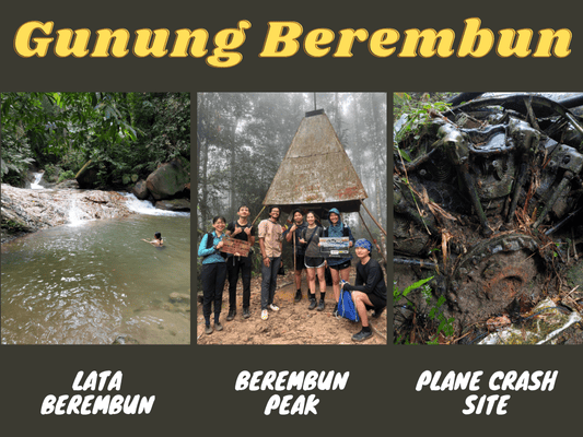
Lata Berembun Waterfall


(+1)9.52am: A quick stop at Lata Berembun.

10.08am: Continue the hike with a brief steep incline after the waterfall.

(+4)10.12am: Followed by a landslide area where you need to be extra careful to pass through the slippery track with steep drop-offs.


(+6)10.18am


(+13)10.31am

Huge millipede.
Gua Kambing

(+31)11.02am: Arrived at Gua Kambing (Goat Cave) for a short break before the big climb towards the summit. It is not exactly a cave but a huge rock with sheltered ground below.

11.14am: We continued the hike after the break. The trail is just before Gua Kambing (not through Gua Kambing).

(+1)11.15am: The distance from Gua Kambing to Gunung Berembun is around 700m or less (just about ⅕ of the length from the trailhead to Gua Kambing), but the elevation from here gets serious.

(+3)11.18am

(+5)11.23am

The fog thickened as we reached higher ground.

(+11)11.44am

(+10)11.54am

The misty forest.
Gunung Berembun Negeri Sembilan Peak (1,014m)


(+22)12.16pm: Finally, we arrived at the summit of Gunung Berembun after an hour of steep climbing from Gua Kambing.

Lunch break: Lepat Pisang from Nasi Lemak Ikan Sembilang Lenggeng.

Thick fog started to surround the peak.


12.55pm: After lunch break, we began our journey to the crash site. The rain started not long after.


(+4)12.59pm: The trail is mostly downhill from Gunung Berembun peak to the crash site.
RAF B-24 Liberator (KL 654/R) Crash Site


(+56)1.55pm: One hour after departure from Gunung Berembun peak, we arrived at the junction turn-off to the crash site. It is a short but steep downhill climb to the crashed plane.


(+4)1.59pm: Arrived at the first site of wreckage, where you’ll find the engine parts and parts of the plane body.


Crashed on 23rd of August 1945, the plane’s tyre is surprisingly still looking fully inflated.

(+2)2.01pm: Follow the trail to the second site of the wreckage just a minute or two away.

Another piece of the plane along the way.


(+1)2.02pm: Lastly, we arrived at the next wreckage, mostly the plane’s body and a wing folded inwards into the body.
Trail To Gunung Telapak Buruk

(+13)2.15pm: We climbed back up to the junction. The trail to Gunung Telapak Buruk has been closed so we could only head back the same way.


A mushroom that looks like a butt 🍑, and another one that looks like a strawberry flavored pancake 🥞.
(+3h18m)5.38pm: We returned to Lata Berembun for a soak before heading back to the car park at 6.25pm.


We had Jelebu’s signature sate tulang close to Seremban but the best one I had so far is at ABM Sate Tulang Jelebu.
Have this guide helped you? Tag @meowtainpeople in your hiking stories & posts!

*Captain Planet passing by* Remember, please take care of our environment, and please don’t destroy the Nature. Leave no trash behind and take back only photos and memories (and also some trash if you can). Walk on the designated path and stay in the middle as much as you can, so that the exposed soil doesn’t spread/corrode further. BE ONE WITH NATURE *flies away*
Affiliate Links to support this site:
Yay for transparency!: The links above are affiliate links, and at no additional cost to you, I earn a commission if you make a booking/purchase after clicking the links. I recommend only products and companies I use. Your support helps me keep the site going 🙂
Want to do the same affiliate marketing with your site? Use this AccessTrade platform link to receive RM5 reward.