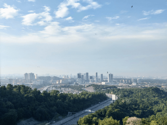
Kota Damansara Community Forest Reserve (Taman Rimba Komuniti Kota Damansara), KDCF in short, is a community-managed low land forest. The community forest occupied almost half of Kota Damansara, and served as the lung of the urban city.
A most special thanks to KOTA DAMANSARA COMMUNITY FOREST SOCIETY, for protecting and preserving this green space!
KDCF is the remainder of the larger 6,590 hectares Sungai Buloh Forest Reserve. Thanks to a civil society campaign, this 321.7 hectares of forest is preserved and prevented from turning into housing.
Kota Damansara Community Forest Trails
KDCF’s trails are well maintained by KDCF society’s volunteers and partners such as MyChangkul and Temuan Orang Asli Community. Thus, the forest trails are very nice and enjoyable by hikers, trail runners, and mountain bikers alike. The paths are relatively easy and flat. The most difficult parts are only the steep trails near Tiga Puteri Peak.
Also, the trails are well mapped and explained in Kota Damansara Forest website.
Kota Damansara Community Forest starting point:
First, you start your hike by registering yourself at the entrance.
Important: Where to park your vehicle
Please do not park around the De Rozel Apartments road or the KDCF roundabout. Please park in the shops area around 7-Eleven, and walk the rest of the way in. It is just a 10-15 minutes walk (take it as a pre-hike warm ups / jog). Let’s all be considerate hikers and park visitors!
Denai Puteri Tiga Peak
For the most direct path from KDCF starting point to Tiga Puteri Peak, take Temuan trail to Sahabat, and then Unity trail. It would take about 1 hour using casual speed without stopping. You can refer to the signboards or apps like Viewranger and Kamoot for navigation.
Lastly, at the Unity trail nearing the peak, the path will start to be steeper. At this point it would take about 10 minutes to reach Denai Puteri Tiga peak.
When you see this last climb with ‘Had Sempadan Lebuhraya’ (highway border), you’ll know you’re a couple minutes away from the peak.
Follow the ‘Longkang’ path at the top, and you will finally reach the peak of Denai Puteri Tiga.
Denai Puteri Tiga peak: Well, it is more of a man made terrain, cutting the hill to make way for the highway.
Going back, I used the Serenity Trail as it had much fewer traffic than the Temuan Trail. This longer path took me 1.5 hours to reach the exit. Several ‘Petaling’ signboards indicate the Petaling trees, not that the trails are bringing you to Petaling Jaya haha.
Lastly, I took the Scout Trail and then the Salleh Trail by the lake. You can choose to walk on the tarmac path, or stick to the trail just beside it.
At first, I chose the trail path but then I encountered a sizable macaque blocking the path in the distance. She was not hostile but to be safe, I made a detour and used the tarmac road instead.
Have this guide helped you? Tag @meowtainpeople in your hiking stories & posts!
Affiliate Links to support this site:
Yay for transparency!: The links above are affiliate links, and at no additional cost to you, I earn a commission if you make a booking/purchase after clicking the links. I recommend only products and companies I use. Your support helps me keep the site going 🙂
Want to do the same affiliate marketing with your site? Use this AccessTrade platform link to receive RM5 reward.
*Captain Planet passing by* Remember, please take care of our environment, and please don’t destroy the Nature. Leave no trash behind and take back only photos and memories (and also some trash if you can). Walk on the designated path and stay in the middle as much as you can, so that the exposed soil doesn’t spread/corrode further. BE ONE WITH NATURE *flies away*


