
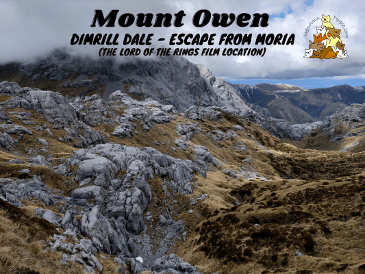
At 1,875 meters, Mount Owen is the highest peak in Kahurangi National Park. Climbing Mount Owen requires a good level of mountaineering experience, while also being well equipped and self-sufficient. You also need confidence in walking on narrow glaciated karst landscapes with deep shafts drop-offs.
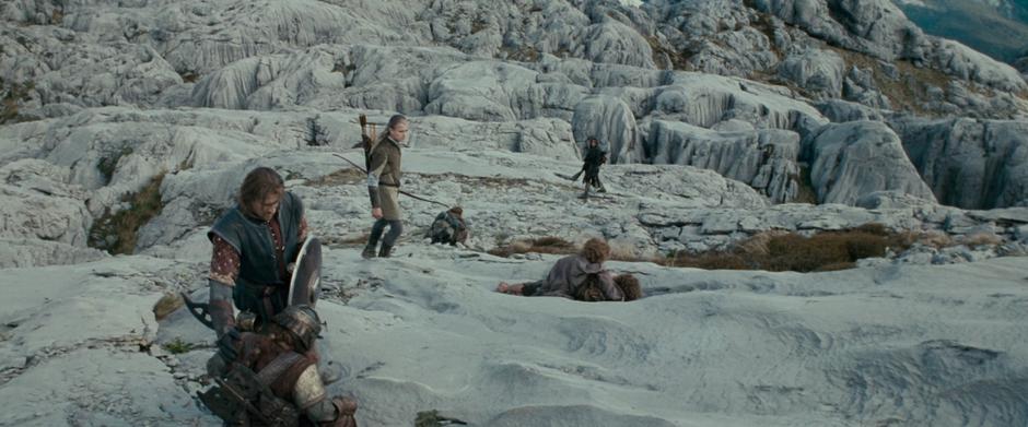
The Lord of The Rings fans will find extra thrill traversing on Mount Owen, as it is used as the epic filming location for Dimrill Dale, the place where the Fellowship escaped the horrors of Moria. The on-site filming took ten days.
Getting To Mount Owen (New Zealand)
There are two routes to reach the peak of Mount Owen: The Northern approach (~6 hours on clear days) and the Southern approach (~7 hours). The Northern approach is the recommended way which will be covered in this post. The Southern approach is the most difficult and requires river crossings and more route finding as there are no rock cairns or markers above the bushline.
Mount Owen Northern Approach (2 Days Return)
Driving To Courthouse Flat Campsite

Mount Owen Northern Approach starts at Courthouse Flat Campsite Car Park. The drive there involves crossing Dart River ford on the Wangapeka River. While a concrete culvert is built over the river, the water can still flow over it when the water level is slightly higher. Before traveling, check the river flow for Wangapeka at Walter Peak. As a guide, do not cross if the flow graph exceeds 40 cumecs. Upon arrival at the crossing, re-access the flow condition based on your vehicle type and driving skill.
After crossing the Dart River ford, there are still several fords to cross before reaching the campsite car park. While smaller, they do not have a culvert or bridge built over it, so two-wheel-drive or low vehicles might find it tricky to drive over the fords, especially for those streams with smooth slippery pebbles. It is recommended to use a four-wheel-drive vehicle, or have another vehicle in your group to pull a stuck car if needed. There may not be mobile phone reception in the area to call for vehicle towing service.
Other than that, do remember to check the weather forecast for your return trip to ensure you don’t get stuck due to the rising river. Moreover, do keep a stash of emergency food and supplies in your vehicle just in case you have to wait a few days for the river flow to return to a safe level to cross the fords.
Courthouse Flat Campsite to Granity Pass Hut via Ridge Track (8.3km)


6.56am: There are two track options between Courthouse Flat and Granity Pass Hut: via Ridge or via Blue Creek. The first one is an open track on a ridge while the Blue Creek Track goes past old gold mining relics and side trips to some beautiful rivers and pools. I will first take the Ridge option up, and will take the Blue Creek option coming back down.

(+6)7.02am: First, through an overgrown grass track.

(+25)7.27am: Then, begins the steep climb up the ridge.

(+22)7.49am


(+8)7.57am


(+9)8.06am: The Ridge Track and Blue Creek Track join and continue onwards to Granity Pass Hut.

(+40)8.46am: A brief clearings offering views to the north and west but it was a foggy day.

(+7)8.53am: The track heads down and back into the forest.


(+6)8.59am: The track goes over an open saddle for a couple of minutes, before re-entering the forest.

(+12)Climbing down the notorious and steep section called “The Staircase”.

(+7)9.19am: Sidling around marble bluffs.

(+1)9.20am: Suddenly, I spotted an unusual square hole in the rock face on the opposite mountain. I reckon that could be an old mine site entrance into the natural cave networks.


(+10)9.30am: Rock faces of the Ghost Valley.

(+23)9.53am: Walking on the dry marble creek bed.

(+4)9.57am
Granity Pass Hut

(+9)10.06am: Arrived at Granity Pass Hut.

This is where I will stay for the night after coming back down from Mount Owen.

Interesting information about the hut, Mount Owen and the surrounding landscapes of Kahurangi National Park. A funny statement says “two Nelson men made a day trip … … to avoid the Saturday housework at home”. Well, men would do anything to avoid doing housework hahaha!
Granity Pass Hut to Mount Owen


10.56am: After an early lunch break in the hut, I set off to Mount Owen. The route to Mount Owen starts at the back of the hut.

(+4)11am: A large outcrop near the hut.

(+4)11.04am

(+11)11.15am


(+10)11.25am: Large tussock grassland.

(+20)11.45am: Approaching Mount Owen massif.


(+5)11.50am: A few tarns around the foothills of Mount Owen.

(+5)11.55am: The path up to Mount Owen.

(+3)11.58am: Climbing up the rocky route. There are some rock cairns around to guide the way, but route finding skills are still essential.

(+2)12pm: A narrow path with a deep crevasse below.

(+2)12.02pm: Other than the many crevasses around the mountains, beneath the mountain lies a maze of subterranean caves, including New Zealand’s longest cave network, the Bulmer Cave System. Well preserved moa remains and a complete skeleton of the giant New Zealand eagle have been discovered in Mount Owen caves. Both mythical creatures are extinct.

(+3)12.05pm

(+4)12.09pm: Walking over this slab of rock across the large crevasse (don’t fall!).

(+6)12.15pm

(+3)12.18pm: A natural rock arch.

(+9)12.27pm: What a view! Many endemic alpine and subalpine plant species are a feature of the area. Many had found refuge in sheltered pockets during the last glaciation to survive. They continued a long line of evolutionary adaptation to suit New Zealand’s unique, local environment. Some of these plants found nowhere else are the Marino mountains’ forget-me-not (Myosotis concinna) and the Marino mahoe. In summer months, look for the array of alpine flowers seeking shelter amongst the rock.

(+9)12.36pm

(+20)12.56pm: Some snow may be present even in the summer.


(+4)1pm: Approaching the summit of Mount Owen. The large stack of cairn ahead marks the peak.
Mount Owen Peak

(+4)1.04pm: Arrived at the peak of Mount Owen. A base for some kind of platform was built onto the rock.


Mount Owen summit views with low clouds.

The low clouds were blocking some of the views but it seemed like they were slowly rising from the afternoon sun, so I sat down next to a small wall of rock to shelter from the chilly wind, while waiting for the clouds to rise for a clearer view.


After a while, the clouds have gotten a little higher. I then captured more views surrounding the summit of Mount Owen.
Mount Owen to Granity Pass Hut

1.29pm: Heading back down to the hut.

(+6)1.35pm

(+8)1.43pm

(+8)1.51pm


(+15)2.06pm: Back to the rock slab crossing with the large crevasse.

(+64)3.02pm: Returning to the Ghost Valley.

(+4)3.06pm: Arrived back at the hut to stay for the night.
Day 2: Granity Pass Hut to Courthouse Flat Campsite via Blue Creek Track (8.6km)

8.26am: After breakfast, I packed my things and left the hut.

(+35)9.31am: Climbing “The Staircase”.

(+10)9.41am: Foggy day.

(+51)10.32am: At the junction where the Ridge and Blue Creek Track joins.


(+21)10.53am: For the return trip, I took the Blue Creek Track. Just like the Ridge track, it can be rather steep in some parts.
Side Trip: Blue Creek Resurgence


(+48)11.41am: The turn-off junction to Blue Creek Resurgence side trip.


(+2)11.43am: Some old mining relics including a stamping battery along the track.


(+6)11.49am: The path down to Blue Creek Resurgence can be very slippery due to the moss growing on the rocks. I had a slip while heading down but fortunately did not sustain any serious injuries (just a bleeding finger). A resurgence occurs when an underground stream is found to surface. For Blue Creek, this happens where the marble and sandstone contact on a fault-line. As a major resurgence of the vast network of streams in the Mount Owen Massif, it rises over 30 meters at 45 degrees angle.


(+5)11.54am: Back to the main track, more mining relics along the way.
Side Trip: Lutine Pool


(+27)12.21pm: A 450 meter side trip (200 meters before the exit to Courthouse Flat) to Lutine Pool.

(+4)12.25pm: Back to the main track. Just before the exit is a fine example of hand-stacked tailings on this goldfield. It’s a legacy of the waterfall sluicing technique used here in the 1860’s by parties of 8-10 miners. Water was progressively diverted down the sluice face to wash gold-bearing dirt through the sluice boxes, which trapped the gold specks. Nearby stones were hand-stacked on worked ground and formed the tail race channel.

(+3)12.28pm: Arrived at the car park at Courthouse Flat Campsite.


Headed back to my accommodation at Happy Apple Backpackers to rest for a couple days before my next 5-day long hike, I discovered two great food spots nearby: Toad Hall that serves mind blowing real fruit yogurt ice cream and seafood chowder, and Wrapshack that serves budget friendly yet extraordinary pulled pork wraps.
Have this guide helped you? Tag @meowtainpeople in your hiking stories & posts!

*Captain Planet passing by* Remember, please take care of our environment, and please don’t destroy the Nature. Leave no trash behind and take back only photos and memories (and also some trash if you can). Walk on the designated path and stay in the middle as much as you can, so that the exposed soil doesn’t spread/corrode further. BE ONE WITH NATURE *flies away*
Affiliate Links to support this site:
Yay for transparency!: The links above are affiliate links, and at no additional cost to you, I earn a commission if you make a booking/purchase after clicking the links. I recommend only products and companies I use. Your support helps me keep the site going 🙂
Want to do the same affiliate marketing with your site? Use this AccessTrade platform link to receive RM5 reward.