
Paparoa Track is one of New Zealand’s Great Walks and it’s the first purpose-built, shared-use hiking and mountain biking Great Walk in Paparoa National Park. This Great Walk crosses the remote wilderness of Paparoa Range, through limestone karst landscapes, alpine tops and thriving rainforests.
Paparoa Track Great Walk Booking
All Great Walks in New Zealand require booking in advance for the huts and campsites. Off-site camping is not allowed on the Great Walk tracks. Here is the online booking site for all Great Walk accommodations. Lookout for the opening dates of bookings for each season as the popular great walks tend to get fully booked pretty fast.
If the slots are fully booked and you are flexible with your dates, you can run through the site’s booking calendar regularly to lookout for any new slots, as people often cancel their booking days/weeks/months before the trip. Don’t simply book and cancel though, here are the cancellation fees in detail.
Which Huts To Stay On Paparoa Track
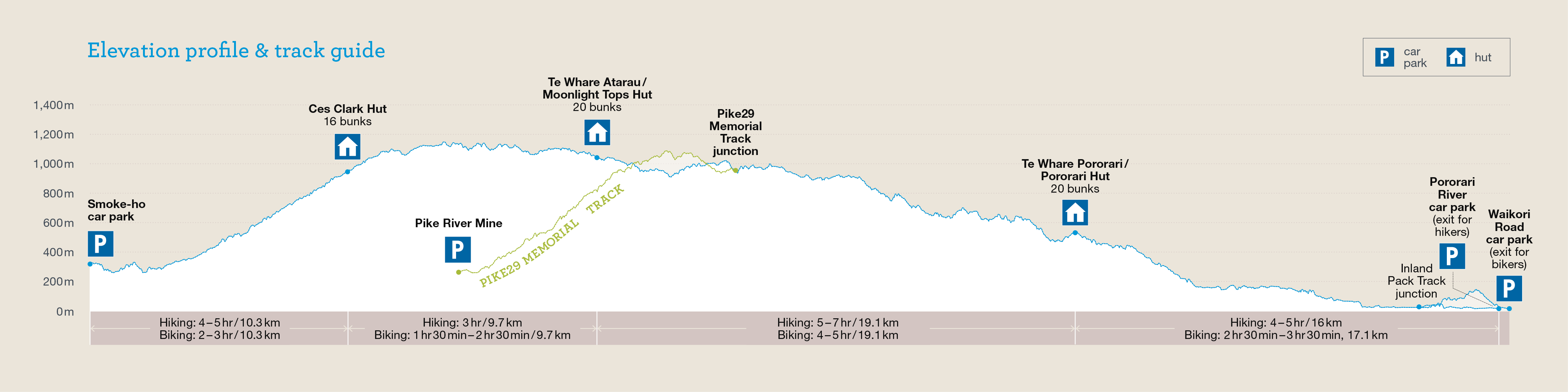
There are three huts on the Paparoa Track: Ces Clark Hut, Moonlight Tops Hut and Pororari Hut. Which ones to stay for the night depend on how many days you plan to walk the track. A chill four-day walk gives you the opportunity to stay in all three huts.
On the other hand, the more common three-day walk works with staying in Moonlight Tops Hut and Pororari Hut. It is less practical to skip Moonlight Tops Hut (best sunset and views!), because Ces Clark Hut and Pororari Hut are 28.8km and 10 hours apart.
Other than that, you could also do a two-day return trip on a section of Paparao Track and stay in one of the huts if you don’t intend to walk the full length.
Where To Start / Finish + Paparoa Track Transportation
The full Paparoa Track can be walked from either end: Blackball via Smoke-Ho Car Park, or Punakaiki via Pororari River Track Car Park or Waikori Road Car Park. Blackball and Punakaiki are around 63km and one hour drive apart. Unless you are doing a return track back to the start, you would need to organize your transport back to your car at the other end, or back to the town/village.
Key-swapping (two hiking parties starting from the opposite ends swapping car keys as they meet on the track) is possible but not for the full Paparoa Track, as Smoke-Ho Car Park in Blackball is intended for day use only (no overnight parking). Well, actually you could, if one party starts from Punakaiki a couple days earlier than the one from Blackball, so the car parked in Blackball does not have to stay overnight when the driver swaps it on the first day.
Alternatively, one can hike a ⅔ section of Paparoa Track by starting/finishing at Punakaiki and:
- Andersons Flat in Atarau via Moonlight Pack Track to Paparoa Track junction
- Barrytown via Croesus Track to Paparoa Track junction
- Pike29 Memorial Car Park in Atarau via Pike29 Memorial Track to Paparoa Track junction

The easiest option is to book a shuttle service like I did with Punakaiki Beach Camp. The track transport service can be easily booked online. In the morning before starting the great walk, I arrived and parked at their car park in Punakaiki, and hopped onto the shuttle bus heading to Smoke-Ho Car Park in Blackball to start my hike. The best thing after the end of the long hike back to Punakaiki is the complimentary hot shower! Also, accommodation options before and after the great walk are available.
Things I packed for Paparoa Track
- 40L Hiking Backpack from Decathlon with rain cover and a large strong rubbish bag lined inside as additional water protection
- PTT Outdoor’s HIGH PEAK Easy Travel Sleeping Bag
- TOMSHOO sleeping bag liner
- Quechua Hiking Raincoat
- Sun Protect long-sleeved running tee, Quick dry running shorts + Kiprun running socks (for the day)
- Quechua Hiking Fleece Jacket
- Ski base layers top + pants + warm hiking socks + gloves from Decathlon (as sleepwear)
- Extra down jacket (didn’t use but important to bring, just in case)
- Adidas Kampung (not from Adidas, Malaysia’s trusty rubber hiking shoes)
- Flip flops (for walking around huts)
- Sun hat
- First Aid Kit, Compass & Whistle
- Rechargeable headlight (red light recommended for kiwi bird spotting)
- Phone (with booking confirmation pdf file), powerbank & charging cables
- Food and snacks (World’s Famous Sheffield Pies, wraps, tuna spread, Pic’s Peanut Butter Slugs, muesli, mixed nuts, energy bars, beef jerky), paper towels, rubbish bags
- Water bottles (1-2L)
- HydroBlu lightweight waterfilter
- CuloClean portable bidet, toilet paper
- Toothbrush, toothpaste, hand sanitizer, soap, hairbrush
- Fire lighter (useful for lighting fire wood if staying in a hut)
- Folding scissors
Before you go, check the weather forecast for Paparoa Track. Located in the ‘roaring forties’, the West Coast is very exposed to the strong Westerlies, and the freezing Southerlies coming from Antarctica. Weather in Paparoa National Park can be extreme when these winds occur.
Paparoa Track - Day 1
Paparoa Track can be walked in both directions. On my trip, I walked the common Black Ball to Punakaiki direction.
Smoke-Ho Car Park to Ces Clark Hut (10.3km)

9.27am: The shuttle bus dropped us off at Smoke-Ho Car Park and we began the walk on the historic (gold mining) Croesus Track. Just when I started the walk I walked past an interesting layered wall of black coal but somehow I did not think of snapping a photo of it…

(+3)9.30am: The split junction to Mount Watson Route for experienced trampers wanting more challenges. You’ll find the other end of this route near the highest point not long after Ces Clark Hut.


(+13)9.43am: Sharing the track with mountain bike riders. Riders will find this section very tough due to steep elevation and rough track. Don’t be discouraged as it’ll get easier and easier not long after Ces Clark Hut and eventually a downhill ride to the end.


(+19)10.02am: Walking past the first historic hotel site from 1868. No actual remains of the hotel but an open area with a picnic table nearby.


(+7)10.09am: Blackball Creek swingbridge.


(+14)10.23am

(+12)10.35am: Second hotel site from 1898.

(+8)10.43am: Beautiful nikau palm trees.
Side Trip: Garden Gully Battery & Historic Hut

(+45)11.28am: Side trip junction to Garden Gully where you’ll find a historic hut and a gold mining stamping battery.

(+6)11.34am: The 1930’s hut site. This hut is for historic appreciation only, not for visitor accommodation. Do not use the fireplace as you could burn down the historic hut.

(+4)11.38am: The onward trail towards the mine and battery site involves a stream crossing (follow the orange triangle markers) and possibly some muddy trails.

(+5)11.43am: This less-travelled trail is not as wide or maintained as the main great walk track, but still pretty obvious and navigable. I had to navigate around a couple fallen trees on the trail.

A sun bathing weka.

(+5)11.48am: Another junction for the mine site (20 minutes) and battery site (5 minutes).

(+4)11.52am: I headed over to the battery site first and crossed over a small stream.

(+2)11.54am: Arrived at Garden Gully Battery (1905) site.


Pretty impressive and well preserved gold stamping battery structure.


Some lose relics around on the ground.

(+7)12.01pm: Back to the junction, I then headed towards the mine site. This trail was even more rugged and untouched.

(+11)12.12pm: Some random mining relics along the path.

Beware of the native stinging nettle plants (onga onga) by the trail.

(+9)12.21pm: Some steep loose soil climbs before the dead end.

(+2)12.23pm: Just a few loose relics at the mine site, nothing much to see here. There were mine shafts around the area but I was later told by the hut warden that these shafts have collapsed and buried by nature.

(+26)12.49pm: Back to the stream crossing.

Had my World’s Famous Sheffield Pie for lunch break by the stream before continuing my journey.
Back To Paparoa Track

1.12pm: Back onto the main track after my lunch break.

A kākā (New Zealand’s large native parrot) looking for food, probably insects in the tree as it was biting off pieces of wood.


(+44)1.56pm: As the track climbs higher, the podocarp and beech forest turns into the subalpine forest with smaller plants. You could spot Ces Clark Hut as you zig-zags up towards the top.


(+7)2.03pm: But first, you’ll pass by the historic Croesus Top Hut (not for staying).
Ces Clark Hut

(+3)2.06pm: Arrived at the 16-bunk Ces Clark Hut.


Interiors of Ces Clark Hut. Looked very new and well presented.


Great view from the deck of Ces Clark Hut! Also, there is mobile reception at this hut.
Ces Clark Hut to Moonlight Tops Hut (9.7km)

2.08pm: After a brief stop at Ces Clark Hut, I continued my journey towards Moonlight Tops Hut where I spent my night.

(+7)2.15pm: The track will continue to climb higher for a bit before starting to go flat-ish / undulating and eventually downhill.


(+14)2.29pm: Some views along the way.
Side Trip: Croesus Knob View Point

(+7)2.36pm: The side trip turn-off to Croesus Knob View Point. You can drop off your heavy backpack here for the side trip but do bring along your essential and emergency equipment.

(+5)2.41pm: The trail is steep and rough, not suitable for mountain bikes.

(+1)2.42pm: Here you’ll find the other end of the advanced Mount Watson Route (which you saw at the other end in the beginning of Smoke-Ho Car Park). For Croesus Knob, follow the orange triangle pointing to the right of this signboard.

(+5)2.47pm: The steep trail can be slippery with loose rocks and smooth grass so take extra caution on your footing.


(+4)2.51pm: Reached the top of Croesus Knob (1,204m).


The panoramic views from Croesus Knob with expansive views of Grey River/Māwheranui and Tasman Sea. On a clear day you might even see Aoraki / Mt Cook.

2.57pm: Heading back down to the main track. Oncoming rain clouds spotted.

An unknown rusted metal structure spotted off the trail.
Back To Paparoa Track


(+9)3.06pm: Heavy clouds have arrived.

(+12)3.18pm

(+8)3.26pm


(+11)3.37pm

(+3)3.40pm: The turn-off to Barrytown exit via Croesus Track.

Heavy clouds surrounded the track.


A bunch of alpine plants known as the vegetable sheep.

Suddenly, it started raining lightly but as soon as I pulled out my raincoat, the rain turned into hail (tiny ice balls) hitting my body. What an experience of the fast changing weather in the West Coast!
Moonlight Tops Hut

(+81)5.01pm: After 7.5 hours of hiking, I finally arrived at Moonlight Tops Hut to stay for the night.

The view from the mountain bike stand.


Hybrid longdrop toilets of Moonlight Tops Hut.

Interior of Moonlight Tops Hut – Common area.

Hut kitchen fitted with cooking stoves.

The awesome view of the deck of Moonlight Tops Hut, making it the best hut on Paparoa Track!

Window view from inside the hut.

There are also solar-powered USB charging ports for your devices.


Near sunset, the hut warden recommended we head out to view the sunset, it was amazing!
Paparoa Track - Day 2
Moonlight Tops Hut to Pororari Hut (19.1km)

8.20am: After breakfast, I began day two of Paparoa Track on a foggy day.

(+13)8.33am: Turn-off to Andersons Flat Car Park via Moonlight Track.


(+5)8.38am: Through the mossy forest.

(+65)9.43am: There is a turn-off junction to the new Pike29 Memorial Track but it was still being constructed during my trip so the track wasn’t opened yet.

(+13)9.56am

(+29)10.25am

(+4)10.29am

(+12)10.41am: Argillite Basin


(+17)10.58am: A large emergency shelter.

(+25)11.23am

(+2)11.25am

(+10)11.35am


(+10)11.45am: Waterfall suspension bridge.

(+7)11.52am: From here I spotted three uniquely positioned boulders by the track.

(+4)11.56am

(+22)12.18pm

(+60)1.18pm
Pororari Hut


(+25)1.43pm: Arrived at Pororari Hut for my second night of Paparoa Track.


The view from Pororari Hut.
Paparoa Track - Day 3
Pororari Hut to Pororari Car Park (16km)

7.51am: Final day morning, I started heading towards the exit to Punakaiki.

(+45)8.36am: Warning sign for the native ongaonga (stinging nettle). These plants were pretty far off the side of the well maintained track so you wouldn’t walk into one if you stayed on the track.


Some stinging nettles found nearby.


(+32)9.08am: Upper Pororari suspension bridge.


(+8)9.16am: Watson Creek suspension bridge.


I encountered this bold cheeky weka on the track who took interest in my phone.

(+45)10.01am: A random small cave by the track.

(+38)10.39am: Upper Pororari River.


(+12)10.52am: Mid Pororari Bridge.


(+8)11am: Junction to continue on Paparoa Track (don’t cross the bridge) and Cave Creek Memorial Track / Inland Pack Track to Bullock Creek (cross the bridge).


(+6)11.06am: Junction to the exits of Pororari River Car Park (walkers only track) and Waikori Road Car Park (biking track). Since I was on foot, I took the track to Pororari River Car Park.


(+5)11.11am: The track follows the Pororari River.


(+9)11.20am: This track will go through a small cave.

(+23)11.43am: A nice view of the Pororari River and gorge.

Lush vegetation by the river.

A pair of paradise ducks and their ducklings.

(+16)11.59am: The view you would see if you start your walk from Pororari River Car Park.

The entrance / exit of Paparoa Track and Pororari River Track.

(+4)12.03pm: Finally, I completed Paparoa Track and exited Pororari River Car Park.

Oh no, a free roaming stray cat… The native wildlife will take a big hit by it.

(+2)12.05pm: Just a short walk to the main road, where I parked my car at the shuttle bus service holiday park not far across the road. Before I hit the road, I took the complimentary hot shower!


On the way to my long drive to Westport, I stopped for the night at Jack’s Pizza & Gasthof, a small hidden hippy pizza bar in the middle of a farm that also offers campsites and cabins. I read good reviews about the pizza but unfortunately the shop was closed during my visit. I paid $10 for a campsite next to a sheep paddock and slept in my car.
Have this guide helped you? Tag @meowtainpeople in your hiking stories & posts!

*Captain Planet passing by* Remember, please take care of our environment, and please don’t destroy the Nature. Leave no trash behind and take back only photos and memories (and also some trash if you can). Walk on the designated path and stay in the middle as much as you can, so that the exposed soil doesn’t spread/corrode further. BE ONE WITH NATURE *flies away*
Affiliate Links to support this site:
Yay for transparency!: The links above are affiliate links, and at no additional cost to you, I earn a commission if you make a booking/purchase after clicking the links. I recommend only products and companies I use. Your support helps me keep the site going 🙂
Want to do the same affiliate marketing with your site? Use this AccessTrade platform link to receive RM5 reward.