
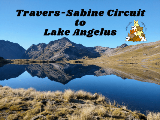
The Travers-Sabine Circuit is a 80 kilometers, 4-7 days advance tramping track in Nelson Lakes National Park in St Arnaud of Nelson/Tasman region. The circuit features tranquil beech forests, tempting clear rushing streams, an alpine saddle crossing, and 2000‑m‑high mountains.
In addition, the Rotomairewhenua / Blue Lake, thought to be the clearest natural freshwater lake in the world, is a long but worthwhile side‑trip from the main circuit.
Furthermore, Travers-Sabine Circuit can be combined with the tracks to Angelus Hut. While this adds a considerable level of challenge to the already challenging main circuit, it would surely be a rewarding journey for experienced and fit hikers. Get ready to be in awe by the 1,650-meters-high Angelus Hut sitting on the shore of beautiful Lake Angelus, surrounded by spectacular mountain views.
Travers-Sabine Circuit Huts & Angelus Hut Booking

During my trip, the huts and campsites on the Travers-Sabine Circuit were still non-bookable walk-in (first come, first serve) accommodation payable with pre-purchase hut tickets. But recently they have become bookable huts to accommodate the high traffic usage of some huts used by TA walkers (half of the circuit is part of Te Araroa Trail). The huts now need to be booked in advance and you can do it on DoC huts booking site. Campsites do not require booking at the moment but you still need to purchase the standard hut tickets (one for each night) from any i-Site or visitor centers beforehand.
For Angelus Hut and Campsite, both are bookable here.
Which huts or campsites to stay for the night depend on how many days you plan to walk the track.
Things I packed for Travers-Sabine Circuit + Angelus Hut Routes (5 Days)
- 40L Hiking Backpack from Decathlon with rain cover and a large strong rubbish bag lined inside as additional water protection (plus a separate sackpack to carry my tent)
- Forclaz Trek 100 3 Seasons Dome Tent (heavier than most tents but very good wind resistance and waterproofing)
- PTT Outdoor’s HIGH PEAK Easy Travel Sleeping Bag
- TOMSHOO sleeping bag liner
- Quechua Hiking Raincoat
- Sun Protect long-sleeved running tee, Quick dry running shorts + Kiprun running socks (for the day)
- Quechua Hiking Fleece Jacket
- Ski base layers top + pants + warm hiking socks + gloves from Decathlon (as sleepwear)
- Extra down jacket (didn’t use but important to bring, just in case)
- Adidas Kampung (not from Adidas, Malaysia’s trusty rubber hiking shoes)
- Flip flops (for walking around huts & campsites)
- Sun hat
- First Aid Kit, Compass & Whistle
- Rechargeable headlight
- Phone (with booking confirmation pdf file), powerbank & charging cables
- Food and snacks (Sandwiches, wraps, tuna spread, Pic’s Peanut Butter Slugs, muesli, mixed nuts, energy bars, beef jerky), paper towels, rubbish bags
- Water bottles (2L)
- HydroBlu lightweight waterfilter
- CuloClean portable bidet, toilet paper
- Toothbrush, toothpaste, hand sanitizer, soap, hairbrush
- Fire lighter (useful for lighting fire wood if staying in a hut)
- Folding scissors
Before you go, check the weather forecast for Travers, as well as Angelus Hut weather forecast. Located in the ‘roaring forties’, New Zealand is very exposed to the strong Westerlies, and the freezing Southerlies coming from Antarctica. Weather in the south island can be extreme when these winds occur.
Travers-Sabine Circuit - Day 1
Travers-Sabine Circuit Starting Point / Trailheads
Travers-Sabine Circuit starts and ends at the north of the circuit. Several options available close to each other:

- The actual starting trailhead of the circuit (clockwise), with a small car park on the opposite road. It’s a 2km walk on the road to the ending trailhead of Travers-Sabine Circuit / Angelus Hut Track.
- Mount Robert Circuit trailhead, with a large car park next to it. It’s 1.7km away from the actual starting trailhead above, and 300m away from the ending trailhead of Travers-Sabine Circuit / Angelus Hut Track. You can enter the trailhead here and join the main track of Travers-Sabine Circuit (clockwise, more details below as this is the path I took).
- If going anti-clockwise: Speargrass Track trailhead (also the exit trailhead of Travers-Sabine Circuit if doing clockwise direction)
- If going anti-clockwise through Angelus Hut: Angelus Hut via Robert Ridge Route trailhead
Clockwise direction is recommended as it is easier to cross the Travers Saddle from this direction.
In addition, Nelson Lakes National Park Visitor Centre has a bag storage facility (I paid $4 to store my valuables for 4 nights) available. The trailheads car parks are isolated and there are car theft warnings in the area.
Mount Robert Circuit (Paddy Track) to Travers-Sabine Circuit (Lakeside Track)

10.11am: Enter Paddy’s Track trailhead next to Mount Robert Circuit Car Park.

(+22)10.33am: At the junction, turn off to Lakeside Track, which is the main track of Travers-Sabine Circuit.

(+6)10.39am: Crossing a stream.

(+7)10.46am: Joining into Lakeside Track, turn right towards Whisky Falls and Coldwater Hut.

(+9)10.55am

(+9)11.04am: The track follows close along the shore of Lake Rotoiti.

(+42)11.46am

(+6)11.52am: Large stream crossing.
Side Trip: Whisky Falls

(+2)11.54am: Turn-off junction to Whisky Falls side trip.

(+5)11.59am: Whisky Falls viewpoint.

(+33)12.32pm: Back to the main track, another stream crossing.
Coldwater Hut


(+25)12.57pm: Arrived at Coldwater Hut. To cut off some time, some hikers choose to take a water taxi and drop off here to start off their hike.

Coldwater Hut interior.
Coldwater Hut to John Tait Hut

Before proceeding or taking a rest at Coldwater Hut, please use this biosecurity cleaning station to clean your shoes and gears that are wet or damp from the lake or river water. This is for stopping invasive microscopic algae (that are already present in Lake Rotoiti and Lake Rotoroa) from spreading to other pristine lakes and rivers. These invasive lindavia (lake snow) and didymo (rock snot) can turn crystal clear water into unsightly mossy water, and just one droplet of contaminated water can spoil these waters forever. So, let’s all be a part of the conservation efforts while we enjoy the gifts of nature.

1.07am: Departed from Coldwater Hut and heading to John Tait Hut.

(+3)1.10pm: A river by the track.

(+25)1.35pm: Walk through the clearings of Travers River flats (remnants from the valley’s farming days).

(+23)1.58pm: Travers River.

(+10)2.08pm: Some muddy sections.

(+21)2.29pm


(+32)3.01pm: Swingbridge crossing to the west bank of Travers River.

(+47)3.48pm: At this part of the track, you have to either cross it via the water, or to find an off-track detour to the other side.

(+10)3.58pm

(+3)4.01pm

(+30)4.31pm: Rock fall hazard detour.

(+24)4.55pm: Crossing Hopeless Creek swing bridge.

(+2)4.57pm: Junction to Hopeless Track and Hopeless Hut. I didn’t take that and proceeded on the main track.

(+87)6.24pm: A beautiful cascade creek just before John Tait Hut.
John Tait Hut

(+6)6.30pm: Arrived at John Tait Hut, where I spent my first night on the circuit.


Interiors of John Tait Hut.

Travers River next to the hut.
Travers-Sabine Circuit - Day 2
John Tait Hut to Upper Travers Hut

8.16am: Second day, leaving John Tait Hut after breakfast.

(+23)8.39am

(+22)9.01am: Some muddy/flooded track.

(+7)9.08am: Side trip turn-off to Travers Falls.
Side Trip: Travers Falls


(+7)9.15am: A not-to-be-missed side trip to the 20 meters Travers Falls.

Strong water current plunging into a deep bowl.

(+18)9.33am: Back to the main track.

(+5)9.38am: A bridge to cross the river was destroyed by a flood, so a 30-minute detour was created on the track. The bridge may have been restored now.

(+23)10.01am: A very tempting river pool by the track.

(+25)10.26am

(+33)10.59am: There are some stream and scree sections to cross.
Upper Travers Hut


(+19)11.18am: The track levels and emerges from the trees onto an extensive tussock‑covered flat, where Upper Travers Hut comes into view, nestled at the base of the east face of Mount Travers. Lovely streams close to the hut.


Interior of Upper Travers Hut.

View of the valley from the hut’s deck.
Upper Travers Hut to West Sabine Hut


11.54am: After lunch break, I left Upper Travers Hut towards Travers Saddle, crossing a nice bridged stream near the hut.

What a view!

(+7)12.01pm: Into the boulder‑strewn valley through alpine shrubs.

(+10)12.11pm: Looking back down the valley.
Poukirikiri / Travers Saddle Alpine Crossing

(+7)12.18pm: The start of the Poukirikiri / Travers Saddle alpine pass crossing.


(+1)12.19pm: Follow the snow pole markers up the steep scree slope.

(+7)12.26pm: Not too steep at this side of the saddle.

(+17)12.43pm: Looking back down into the valley.

(+1)12.44pm: Some flowing streams along the route.

(+7)12.51pm: A heart-broken rock?

(+5)12.56pm: Some snow was still present early in the summer.

Looking back.

(+11)1.07pm

(+8)1.15pm: At the top of the saddle at 1,787 meters above sea level, 450m above Upper Travers Hut.

(+12)1.27pm: The view from the other side of Travers Saddle.


(+18)1.45pm: The descent from Travers Saddle to the Sabine forks 1,000m below is steep. It crosses sections of tussocks and scree.

(+15)2pm: Mount Franklin

(+5)2.05pm


Follow the snow poles that turn to the right into the treeline.

(+27)2.32pm: Entering the treeline back into the forest track. Very steep descent at this section.

(+103)4.15pm: Down onto East Branch Sabine River.


(+17)4.37pm
West Sabine Hut

(+115)6.32pm: Finally arrived at West Sabine Hut.

It was a full house! Packed with mostly Te Araroa walkers.

West Branch Sabine River close to the hut.
Travers-Sabine Circuit - Day 3
Side Trip: West Sabine Hut to Blue Lake Hut


8.34am: In the morning, I left most of my stuff at the hut and departed for the big side trip to Blue Lake.

(+16)8.50am: Clear blue water flowing down all the way from Blue Lake.

(+2)8.52am: Some rocky tracks to climb.

(+7)8.59am

(+6)9.05am

(+10)9.15am: Into the forest.

(+47)10.02am

(+4)10.06am: More blue river views!

(+2)10.08am: At this part of the track, either walk through the ankle deep water, or find a fallen tree nearby to cross over to the opposite bank of the stream.

(+15)10.23am: A rock bivy.

(+5)10.28am: Out to the open with views of the river valley.

Some waterfalls created by melting snow were spotted.

(+6)10.34am: Walking through a section used to be a forest before it got destroyed by an avalanche in 1980.

(+7)10.41am

(+6)10.47am: Couldn’t get enough of the river valley views!


(+1)10.48am

(+6)10.54am

(+14)11.08am


(+14)11.22am: Walking past a small lake with a couple of ducks wading the water.

(+3)11.25am

(+9)11.34am
Rotomairewhenua / Blue Lake: Clearest Lake In The World?


(+4)11.38am: Arrived at Blue Lake Hut.

A team of DoC rangers flew in by helicopter to do some hut maintenance (repairing the broken water tank)

Blue Lake Campsite


Next to the hut is the world’s famous Blue Lake / Rotomairewhenua, thought to be the clearest freshwater lake on earth. It may not look like much from the photos but the consistent horizontal visibility of Blue Lake water is around 70 to 80 meters range! To put it in perspective, a diver’s visibility of >40m is considered rare and outstanding. Moreover, visibility in distilled water is (theoretically) about 80m. So, Blue Lake is a close approach to optically pure water!
Some factors that contribute to the clarity of Blue Lake are the lake is spring-fed (clarified water with extremely low particle content). Also, the springs emerge from landslide material that has dammed Lake Constance – which is probably the source water.
While it can be tempting to swim in the world’s clearest lake, please respect this pristine water by refraining from washing or swimming in the lake. A slightest contamination, especially where invasive microscopic algae are common in the area, could destroy the lake’s clarity forever.

1.22pm: Return track to West Sabine Hut. Along the way through the forest valley, you may spot some large boulders that have not had any moss growing on them yet. I was told by a ranger that these are new fallen rocks that got washed down by avalanches high above the valley during the last winter. This shows how risky the path is when snow is present above the valley.

(+96)2.58pm: Back to West Sabine Hut to pick up my things before leaving for Sabine Hut.
West Sabine Hut to Sabine Hut

(+43)3.41pm: Beautiful Sabine River and some waterfalls along the way.

(+14)3.55pm: The track temporarily leaves the river as it flows into a gorge, heads up steeply and descends again before rejoining the river.

(+5)4pm: Tempting water…

(+79)5.19pm: Crossing a few open flats.

(+38)5.57pm: Easy walking through beautiful forest.

(+119)7.56pm: Junction to Sabine Hut / D’Urville Hut.
Sabine Hut

(+38)8.34pm: Thanks to the longer daylight hours during the summer, I managed to arrive at Sabine Hut before nightfall.


Spacious interiors of Sabine Hut. Unlike the crowded West Sabine Hut, only me and another group of three hikers were occupying this hut.

A nice jetty on Lake Rotoroa. I saw a possum (introduced pest) prowling by the hut toilet at night.

A radio to call for Lake Rotoroa water taxi service. The water taxi could take you to Rotoroa Village and could arrange a shuttle transfer to St Arnaud.
Day 4: Angelus Hut via Cedric Track / Route
Sabine Hut to Angelus Hut (via Mt Cedric)

10.04am: The trailhead to Cedric Track / Route is not far at the back of Sabine Hut.

The trail is very steep from the start and some parts can be overgrown / covered by bushes or fallen trees. It’s important to track down the orange triangle markers to find the correct paths.

(+126)12.10pm: Two hours later.

(+20)12.30pm: As I reached the upper forest section, navigation was easier and faster as there were less blockages.


(+10)12.40pm: Reached the edge of the forest into the bushline.


(+15)12.55pm: Views of Lake Rotoroa over the bushline.

(+23)1.18pm: The view of Sabine River valley to the south.

(+2)1.20pm: Climbing towards the ridge.

(+13)1.33pm: Up on the ridge, the route climbs steadily up along the ridgeline.


(+12)1.45pm

A wide panorama shot.


(+13)1.58pm: Guided by orange snow pole markers, the route goes over multiple “peaks” along the narrow ridgeline.

These are alpine plants that grow on dry, rocky mountains. They are known as vegetable sheep, for an obvious reason.

(+13)2.11pm

(+5)2.16pm: Take extra care, steep drop down the slope of loose rocks!


(+11)2.27pm: As you approach the final peak of the ridge, the route turns left onto the slope on the side. As I traversed the slope, loose rocks began to roll as I stepped onto them. I was anxious that I might trigger a small landslide if I moved too much or too fast. Because of the steepness I had to lean towards the hill and to press my hand on it to support myself, but it caused more loose rocks to roll down over my hand and feet. Feeling that I could slide down along with the loose rocks any moment, I moved very slowly and carefully.

(+29)2.56pm: After some careful maneuvering, I finally climbed over the top ridge onto the other side. The two separated small pools of Hinapouri Tarn came into view.


(+3)2.59pm: More climbing along the rocky slopes but the rocks are much bigger on this side. It’s more stable here, but it also means any moving rock could lead to more serious injuries.
Angelus Hut & Lake Angelus (1,650m)

(+43)3.43pm: At last, Lake Angelus and Angelus Hut came into view!

(+10)3.53pm

(+2)3.55pm: Pristine clear alpine lake water of Lake Angelus.

(+11)4.06pm: Arrived at Angelus Hut. There are possible side trips to Hinapouri Tarn, Sunset Saddle, or Angelus Peak (2,075m).


Angelus Hut bunk and vault toilets outside.

Since I booked the campsite, I set up my tent at one of the beautiful spots (designated sand & gravel platforms) beside the lake.

Love the lake view from my tent!

The next morning, I woke up to a calm, sunny day, when the lake was so still it reflected the amazing views like a mirror!

Panoramic shot of the mirror lake.

Some fog began to form as the sun warmed up the area.

There is a smaller lake separated from the larger Lake Angelus.
Day 5: Angelus Hut to Mt Robert Carpark - 12.2km
Take a look at this awesome video by DoC to get an idea of the track:
The walkthrough below is the reversed version of what you’ve just watched.
Robert Ridge Route

9.29am: Starting my journey back to the car park on a fine morning.

(+2)9.31am: The track starts with a short climb over a hill.

(+5)9.36am: Looking back at Lake Angelus and Angelus Hut from the hill.

(+8)9.44am

(+1)9.45am

(+3)9.48am: Passing the turn-off to Speargrass Hut.

(+3)9.51am: Some other tarns.


(+2)9.53am: Here begins the hike along the long series of ridgelines. Some sections are quite steep and tricky as you walk along the scree slopes below the ridges.


(+25)10.18am


(+20)10.38am: Views from both sides of the ridge.

(+8)10.46am

(+4)10.50am: If you zoom in you’ll see the track along the slopes below the ridgeline.

(+36)11.26am

(+16)11.42am


(+13)11.55am: Arrived at a ridge peak called Flagtop (1,324m).

(+31)12.26pm

(+3)12.29pm


(+16)12.45pm: Arrived at Relax Shelter on Mount Robert. There is a rainwater tank here.
Pinchgut Track


After Robert Ridge Route is the Pinchgut Track to Mt Robert car park (3.3km).

(+10)12.55pm: A bench along the track on Mount Robert, overlooking the north side of Lake Rotoiti.


From here the track zigzags down the mountain through the forest.

(+24)1.19pm

(+30)1.49pm: At the exit of the track, I first arrived at the car park used mainly by hikers who go for Angelus Hut or to hike the Pinchgut Track and Speargrass Track.

(+6)1.55pm: Just a short walk down the road to the car park I used to start my Travers-Sabine Circuit.

Back at Nelson Lakes National Park Visitor Centre to collect my laptop I left before my trip. I saw this interesting information and I recalled seeing these threads on trees along my hike. If I saw this earlier I would have tried tasting the sweet honeydew droplets (even though it’s technically insect poops)!


While you’re there, walk and follow the road behind the visitor center to Lake Rotoiti Jetty. Look under the jetty and you would most likely see lots of New Zealand’s native eels getting shades from the sun!


On the drive back to Nelson, I dropped by at Spooners Tunnel to explore a section of the 1,352 meters dis-used rail tunnel.


Back at Nelson, I stayed at the friendly Tasman Bay Backpackers. They serve free hot (chocolate) pudding with ice cream every night!
Have this guide helped you? Tag @meowtainpeople in your hiking stories & posts!

*Captain Planet passing by* Remember, please take care of our environment, and please don’t destroy the Nature. Leave no trash behind and take back only photos and memories (and also some trash if you can). Walk on the designated path and stay in the middle as much as you can, so that the exposed soil doesn’t spread/corrode further. BE ONE WITH NATURE *flies away*
Affiliate Links to support this site:
Yay for transparency!: The links above are affiliate links, and at no additional cost to you, I earn a commission if you make a booking/purchase after clicking the links. I recommend only products and companies I use. Your support helps me keep the site going 🙂
Want to do the same affiliate marketing with your site? Use this AccessTrade platform link to receive RM5 reward.