
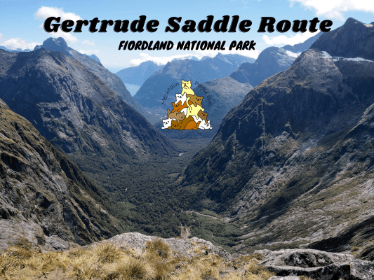
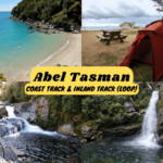
The Gertrude Saddle Route is a short but challenging hike in Fiordland that offers a truly unique experience. It is an exposed, 14 km return route through Gertrude Valley to the top of the saddle. Gertrude Saddle Route is often underestimated due to its relatively short distance and duration (4-6 hours return). The biggest hazard on this alpine route is the smooth and steep rock slabs, which will be very slippery when wet or icy. Due to this, one shall only attempt this route in good weather in the peak of summer, and not to do it when there’s rain, snow or ice. There is also the risk of avalanches during winter.
Gertrude Valley Lookout & Trailhead

The Gertrude Saddle Route starts at Getrude Valley car park, which is also a nice scenic drive stop if you don’t intend to hike.

12pm: A warm sunny day, perfect weather to attempt the Gertrude Saddle Route.


(+3)12.03pm: Follow the pole markers, go through some different types of tracks at the start.

(+9)12.12pm: The track winds towards the valley.


(+12)12.24pm: Look out for a less obvious pole marker on the left into the bush as you cross a wide section of dry stone bed.

(+6)12.30pm: Out of the bush.

(+4)12.34pm: Walk into Gertrude Valley. The path is still flat at this point.

(+5)12.39pm: From the distance you see the valley turns upwards to the left. The Gertrude Saddle is up behind that turn.

(+12)12.51pm: Near the end of the dry, rocky river bed, look for the pole marker on the left. It takes you up from the head of the valley towards the saddle.

(+4)12.55pm: There are limited track markers as you head up the valley so you’ll need good route finding experience.

(+11)1.06pm: Approaching the first river.

(+2)1.08pm: The track is steep and slippery beyond this point. If the weather is turning bad (eg. rain or foggy), turn back and try another day. If you get caught in sudden change of weather, take extreme care to stick to the route as you head down, as wandering off route has led to multiple fatalities.
Gertrude Saddle Waterfalls & River Crossings


(+1)1.09pm: Below the steep waterfall area, you have to cross the river over to the opposite track to continue the climb. Pay close attention and look for the orange triangle markers (easy to miss especially on the way back) that mark the crossing point. It is absolutely essential that you cross at this point. As it was during a very dry period and also during the peak of summer, the water volume was very low and I didn’t have to get my feet wet at the crossing.

(+3)1.12pm: After crossing the river, continue the route up towards the saddle.

(+4)1.16pm: This is the lower fall of Gertrude Saddle, which was quite small during this dry period.

(+5)1.21pm: Track with slippery loose rocks and scree.

(+7)1.28pm


(+2)1.30pm: Avoid wet rocks. Wet rocks have caused fatalities on this route.


(+2)1.32pm: Eventually, the scree route turns into big granite slabs, which can be very slippery when wet or icy.


(+7)1.39pm: Some steel cable to assist your climb along the side of the upper waterfall.
Gertrude Saddle Route - Black Lake

(+5)1.44pm: Arriving at the Black Lake, the water source of the previous waterfalls and rivers.

(+1)1.45pm: Right after the lake is another steep granite to climb. Steel cables are installed to aid your climb.


(+5)1.50pm: Looking back at the Black Lake on the way up.


As I climbed, I noticed some odd-looking white lines along the granite ground. You can also see similar lines from the river pool photo above (underwater). Maybe those are the quartz veins.

(+10)2pm: Some final pushes towards the top of the saddle.
Gertrude Saddle Top

(+16)2.16pm: Finally, at the top of the Gertrude Saddle!

On the saddle, you can now see what’s on the other side of the mountains. Parts of Milford Sound can be seen from here, along with breathtaking views of the valley. A kea landed nearby as I was eating my lunch while enjoying the scenery. I also saw a tour helicopter fly past the saddle from Milford Sound Airport.

2.49pm: After my lunch break I headed down back towards Black Lake.

(+26)3.15pm: Down towards the bottom of the valley, just before recrossing the river. Remember to look for the orange triangles for the river crossing.

(+17)3.32pm: Another of those odd white lines (possibly quartz veins).

(+29)4.01pm: Back into the valley, heading towards the car park.

On the drive back past the small town, I grabbed some delicious sushi bowl and loaded fries in Te Anau.

Then, I checked in at the serene Barnyard Backpackers Te Anau as I have another hike in Fiordland the next morning, at Lake Marian Track. There’s this cute doggo living here!

Sunset by the dorm room door.


Into the twilight, outlined by Fiordland mountain range.
帖子有帮到您吗?在您的登山故事和帖子中标记 @meowtainpeople 吧!

*地球队长经过* 记住,请保护我们的环境,请勿破坏大自然。不要留下任何垃圾,只带回照片和回忆(如果可以的话,还可以捡走一些垃圾)。请在指定的路径上行走,并尽量保持在中间行走,以使裸露的土壤不会进一步扩散/腐蚀。与大自然融为一体吧 *飞走了*
支持本网站的附属链接:
透明度万岁!:以上链接是会员链接,如果您用此链接购买或预订的话,我可以赚取佣金, 而你也不会被收取额外费用。 我只推荐我使用的产品和公司。您的支持可以帮助我保持网站的运行,让我继续用心分享🙂
想在您的网站进行相同的联属网络营销吗?用这个 AccessTrade 平台链接 获取 RM5 奖励。