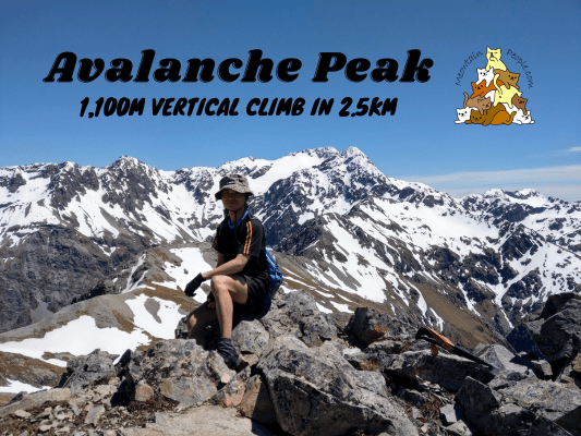
Avalanche Peak in Arthur’s Pass National Park is one of the top hiking spots for hikers traveling to Arthur’s Pass. This mountain-top trip grants you the breathtaking panoramic views of the surrounding Southern Alps on a fine day. With 1,100 meters of elevation gain in just 2.5 kilometers to the peak, do expect heaps of constant steep climbs to the top for the satisfying reward.
While being categorized as an advanced tramping track (50%) + expert route (50%), and people have died here, it is generally doable for most fit people. Just make sure to have some experience with route-finding or pole spotting skill for the second half of the marked route to the peak, plus confidence with high places. During winter or snow covered periods, there are high risks of avalanches and the path is only suitable for experienced and well-equipped alpine mountaineers. Check Avalanche Peak weather forecast.
Round Trip / Return Options For Avalanche Peak
There are two routes up Avalanche Peak, only to be joined 100 meters before the peak. First is the Avalanche Peak Track trailhead near Avalanche Creek Waterfall, and the other is the Scotts Track trailhead opposite of Arthur’s Pass Walking Track. They start in Arthur’s Pass Village and are just 700 meters apart from one another. Both routes have similar distance but the first one is more challenging due to having more steep rocky parts to climb over, and higher possibilities of encountering snow covered paths. The latter has a milder, “smoother”, and less intimidating tussock-covered path.
You can choose to make it a round trip or to return using the same way as you go up. A round trip is excellent for hikers who want to experience different sceneries of both routes. It is recommended to start from Avalanche Peak Track (clockwise) as it’s less risky to climb up the steep rocky paths than to come down from them. Coming down via Scotts Track gives you constant good views of the opposite forest and mountains and also the dramatic Devil’s Punchbowl Falls.
A return trip via Scotts Track would be a good option for less confident hikers who are not so into the steep rocky climbs and opt for the safer, more comfortable path. Nevertheless, it is a big half-day hike and everyone should be properly prepared for it.
Avalanche Peak Round Trip (Clockwise)
Avalanche Peak Track (Elevation 737m to 1200m)
9.49am: Entering the trailhead of Avalanche Peak Track, just opposite of Arthur’s Pass National Park Visitor Centre.
Right away, the constant uphill climb starts.
(+5)9.54am: Steep rocky track.
(+6)10am: Passing by Avalanche Peak Waterfall that can be seen from the road.
(+3)10.03am: The steep track alternates between rocky and rooty.
(+18)10.21am
(+19)10.40am
(+1)10.41am: At the edge of the forest track.
Avalanche Peak Route (Elevation 1200m to 1833m)
(+1)10.42am: After the bushline, the track turns into a route, marked with yellow snow poles.
(+8)10.50am: The views down the village, Bealey Valley to Cora Lynn Station, Black Range, Mount Bealey, and also Mount Temple.
(+9)10.59am: It’s one higher hill after another.
(+9)11.08am: Reaching snow level in the middle of spring.
(+2)11.10am: Continue the climb along the exposed ridges.
(+15)11.25am: The snowy summit of Avalanche Peak is just up ahead.
(+5)11.30am: Some big patches of remaining snow to walk over. (Snow is more likely to be present on Avalanche Route compared to Scotts Route. There was no snow when I headed down via Scotts Route)
(+9)11.39am: Sandals on snow, hmm… Good thing there were some solid footprints created by the other hikers to be stepped on.
(+9)11.48am: The snowy mountains on the other side of Avalanche Peak comes into view right after Avalanche Route and Scotts Route join together and head towards the summit.
Continue along the jagged ridges and bluffs to the summit.
The scariest part would be just before reaching the peak, as you need to grab hold onto the bluffs while passing through narrow passages with steep drop-offs.
Avalanche Peak Summit (Elevation 1833m)
(+7)11.55am: At last, I arrived at the summit of Avalanche Peak!
Somehow, every direction presents totally different views and color tones. What a diverse panoramic view on Avalanche Peak!
Some shots taken with the help of other climbers on the peak.
Scotts Route (Elevation 1833m to 1300m)
12.14pm: Time to head down. This time, I went down via Scotts Route. Notice the yellow and orange pole markers? This is where Avalanche Peak Route and Scotts Route join before the peak. Follow the orange poles for Scotts Route.
(+32)12.36pm: Yet another amazing view as I headed down using Scotts Route.
(+8)12.44pm
(+2)12.46pm
(+13)12.59pm: Walking through the beautiful red fields of tussocks, the Devil’s Punchbowl Falls can be seen from here.
Scotts Track (Elevation 1300m to 737m)
(+23)1.22pm: Enter the forest track into Scotts Track.
(+40)2.02pm
(+11)2.13pm: Exit Scotts Track to the highway. Cross to the opposite side of the road to Arthur’s Pass Walking Track to head back to the village.
帖子有帮到您吗?在您的登山故事和帖子中标记 @meowtainpeople 吧!
*地球队长经过* 记住,请保护我们的环境,请勿破坏大自然。不要留下任何垃圾,只带回照片和回忆(如果可以的话,还可以捡走一些垃圾)。请在指定的路径上行走,并尽量保持在中间行走,以使裸露的土壤不会进一步扩散/腐蚀。与大自然融为一体吧 *飞走了*
支持本网站的附属链接:
透明度万岁!:以上链接是会员链接,如果您用此链接购买或预订的话,我可以赚取佣金, 而你也不会被收取额外费用。 我只推荐我使用的产品和公司。您的支持可以帮助我保持网站的运行,让我继续用心分享🙂
想在您的网站进行相同的联属网络营销吗?用这个 AccessTrade 平台链接 获取 RM5 奖励。

