
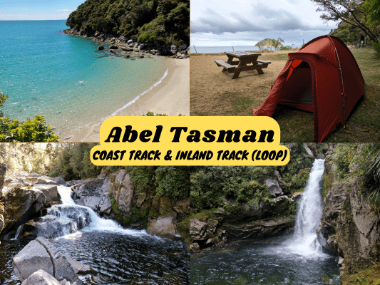
The Abel Tasman Coast Track would be considered as the easiest among the Great Walks in New Zealand. The track features golden beaches, super clear waters, lush coastal forest and beautiful waterfalls. It also gives a very different vibe compared to the other great walks. As many parts of the track are easily accessible by water taxi, you would cross paths with casual tourists chilling or exploring parts of Abel Tasman National Park, while you are on your full tramping loadout. Heck, you would even encounter camper vans at one section.
The Inland Track, on the other hand, is a tranquil tramping track through regenerating and undisturbed forest. While this often-unnoticed Inland Track is not part of the Great Walks set, I find it very pleasant and enjoyable due to its tranquility and lack of crowd (I encountered only one person on this track, who hiked this track and stayed at the huts to study for her exams).
Both Abel Tasman Coast Track and Inland Track are one-way hiking tracks, but they are connected close to both ends, hence can be combined to turn it into a hiking loop. The whole loop could take around 6-8 days (3-5 days for the coast track, 3 days for the inland track), but can be separated into two parts with a rest-and-resupply period between the switch.
Abel Tasman Coast Track Great Walk Booking
All Great Walks in New Zealand require booking in advance for the huts and campsites. Off-site camping is not allowed on the Great Walk tracks. Here is the online booking site for all Great Walk accommodations. Lookout for the opening dates of bookings for each season as the popular great walks tend to get fully booked pretty fast.
If the slots are fully booked and you are flexible with your dates, you can run through the site’s booking calendar regularly to lookout for any new slots, as people often cancel their booking days/weeks/months before the trip. Don’t simply book and cancel though, here are the cancellation fees in detail.
Which Huts / Campsites To Stay On Abel Tasman Coast Track

Source: Department Of Conservation New Zealand
There are 4 huts and 18 campsites along the Abel Tasman Coast Track. Which ones to stay is largely depending on how long or how far you want to hike in a day, which areas of interest you like to spend more time on, and the tide timetable (more about that below).
I stayed at Onetahuti Bay Campsite on the first night for a good beach (well, most of the campsites and huts have good beaches close by), and Torrent Bay Village Campsite on the second night for more time to explore the waterfalls.
Abel Tasman Coast Track Low Tide Crossing Timetable
Other than that, also keep in mind that there are few areas that are unsafe to cross during high tide. While most of them have alternative high-tide routes, there is one compulsory tidal crossing at Awaroa Inlet between Waiharakeke Bay Campsite and Awaroa Hut. Awaroa Inlet can only be crossed within 1.5 hours before and 2 hours after low tide. So, plan and adjust your time and book your huts/campsites accordingly, so that the tide is low when you cross Awaroa Inlet, without having to wait hours for the tide.
Check Abel Tasman Tide Timetable to plan for your great walk.
Abel Tasman Inland Track Huts Tickets
The huts (Holyoakes Shelter, Castle Rock Hut & Awapoto Hut) on the Inland Track are not bookable. Before you go, you need to purchase standard hut tickets ($10 each for adults), one for each night’s stay at Castle Rock Hut and Awapoto Hut, and put it in the honesty box in the hut. Holyoakes Shelter is free to stay but there are only 2 beds available.
The closest place to purchase the hut ticket is at the Motueka i-site Visitor Information Centre, as you drive past the town on the way to Abel Tasman. Or, if you are flying to Abel Tasman via Takaka, you can purchase the hut ticket at Golden Bay Visitor Centre. You can also buy standard hut tickets from any other visitor centres or retailers.
Where To Stay Before, After & In Between Abel Tasman Coast Track & Inland Track

The Barn Cabins & Camp is the most convenient and budget place to stay pre- and post- hike in Abel Tasman National Park. This is because the accommodation is situated just right at the front of Abel Tasman Coast Track and Inland Track south-end entrance/exit at Mārahau.
HIkers doing just the coast track one-way usually start here and take the water taxi between Marahau/Kaiteriteri and Totaranui back to Mārahau, or vice versa. However, this means the 16.5+km remaining section to north-end track end at Wainui would be skipped (lots of nice attractions in the area) unless they do an extra loop via Gibbs Hill Track back to Totaranui. There may also be shuttle bus operators providing transfer services between Wainui and Mārahau track end.
If you have a car and are keen to do a return loop, I recommend the way I did, which is to arrive and stay at Mārahau, leave your valuables and supplies needed for the return track at the accommodation, drive to Wainui Bay Car Park, leave your car there, hike the coast track to Mārahau, rest and resupply at the accommodation and hike the inland track back to Wainui. The logic for starting and finishing at Wainui is, by doing this, you don’t have to carry the full 6-8 days’ worth of supplies for your entire hike. Doing a supply stop at Mārahau cuts the amount of food you have to carry for your trips. Just remember to plan and book ahead the days you need to stay at the accommodation, and let the reception staff know that you are leaving some items for your return stay.
On the other hand, starting and ending the return loop to Mārahau is also an option. However, you would need to carry the full supplies for the 6-8 days on day 1, because there is no shop or accommodation at Wainui track end.
Things I packed for Abel Tasman Coast Track & Inland Track
- 40L Hiking Backpack from Decathlon with rain cover and a large strong rubbish bag lined inside as additional water protection (plus a separate sackpack to carry my tent)
- Forclaz Trek 100 三季圆顶帐篷 (heavier than most tents but very good wind resistance and waterproofing) (for Coast Track only)
- PTT Outdoor 的 HIGH PEAK 便捷旅行睡袋
- TOMSHOO sleeping bag liner
- Inflatable mattress & pillow (for Coast Track only)
- Quechua 登山雨衣
- Sun Protect 长袖跑步 T 恤, 速干跑步短裤 + Kiprun 跑步袜 (for the day)
- Quechua 登山抓绒夹克
- Ski base layers top + pants + warm hiking socks + gloves from Decathlon (as sleepwear)
- Extra 羽绒服 (didn’t use but important to bring, just in case)
- Adidas Kampung (not from Adidas, Malaysia’s trusty rubber hiking shoes)
- Flip flops (for walking around huts)
- Sun hat
- 急救箱,指南针和哨子
- 充电头灯 (red light recommended for kiwi bird spotting)
- Phone (with booking confirmation pdf file), powerbank & charging cables
- Food and snacks (wraps, tuna spread pouches, Pic’s Peanut Butter Slugs, muesli, mixed nuts, energy bars, beef jerky), paper towels, rubbish bags
- Water bottles (2L)
- HydroBlu 轻型滤水器
- CuloClean 便携式射水头, toilet paper
- Toothbrush, toothpaste, hand sanitizer, soap, hairbrush
- Fire lighter (useful for lighting fire wood if staying in a hut)
- 折叠剪刀
Before you go, check the weather forecast for Abel Tasman National Park. Located in the ‘roaring forties’, the South Island is very exposed to the strong Westerlies, and the weather can be extreme when these winds occur.
Abel Tasman Coast Track - Day 1 (Wainui Car Park to Onetahuti Bay Campsite)
Before sunrise, I left my accommodation in Mārahau and drove almost 2 hours to the track end at Wainui Bay Car Park. I will leave the car here until I return via the Inland Track. Also, I left my supplies for Inland Track at the accommodation in Mārahau, for me to pick them up when I finish the Coast Track at Mārahau track end.


6.46am: Started my Abel Tasman Coast Track journey at Wainui entrance.

(+12)6.58am: Serene waters along the estuary edge.

(+5)7.03am: Rolling green hills.


(+28)7.31am: A section of forest track.
Whariwharangi Hut & Campsite

(+31)8.02am: Passing by Whariwharangi Hut by the main track. Built around 1896, this historic hut was restored in 1980 and it is now the northernmost stayable Great Walk hut in the South Island.

Whariwharangi Campsite

(+3)8.05am

(+3)8.08am: A beach close to the hut.
Separation Point / Te Matau


(+28)8.36am: Here is the junction where you can choose to take the direct and shorter main track towards Mutton Cove, or a longer trail through Separation Point to Mutton Cove. I highly recommend not to skip Separation Point as it is one of the most beautiful spots on Abel Tasman Coast Track.

(+26)9.02am: Arrived at Separation Point. Near the cliff edge below is a small lighthouse.

The borderless sea. I guess the earth’s surface is too curved to see the North Island from here.

(+5)9.07am: The Separation Point pole, it marks the geographic boundary between Golden Bay and Tasman Bay. Take extra care if you head down the steep trail down to the lighthouse and pole area. You can leave your heavy pack at the top.

You may spot wildlife along the rocky coast of Separation Point.


I spotted a few seals, some resting on the rocks, while some were swimming in the water.

(+13)9.20am: Climbing back up the steep trail back on track.

(+9)9.29am: The direct path between Separation Point and Mutton Cave involves a section of sandy beach route.

From afar I thought they were penguins on the beach, but they are a species of shags.

Some huge mussel shells.

(+6)9.35am: Just follow the beach until you see the orange triangle marker on a small rocky hill. Go over the rocks and you’ll arrive at Mutton Bay.
Mutton Cove Campsite


(+7)9.42am: Passing through Mutton Cove Campsite.

(+14)9.56am: A section of forest track.

(+41)10.37am: Out to the beach track through Anapai Bay.
Anapai Bay Campsite


(+1)10.38am: Anapai Bay Campsite
Tōtaranui Campground

(+48)11.26am: Suddenly, the walking tracks turned into wide vehicle roads, and I passed by this historic building known as Ngarata Homestead / Tōtaranui Education Centre, a bookable (one year in advance) homestead for private groups.

(+7)11.33am: Walking along Tōtaranui Road which is part of Abel Tasman Coast Track. This road is frequently accessed by tourists in cars and caravans who are staying at Tōtaranui Campground. It felt weird to see cars and tourists around on the tramping track.

The trees had some odd patches growing among the leaves.


Tōtaranui office and beach.

There are even phone booths around here, heh.

(+6)11.39am: Continued my journey via the south coast track.


A pūkeko and a kererū.

(+20)11.59am: A 100m side trip to Skinner Point Lookout.

(+8)12.07pm

(+9)12.16pm

(+9)12.25pm: A small section of beach route through Goat Bay. This section may be impassable during spring high tides.

(+13)12.38pm: End of Goat Bay beach track.
Waiharakeke Bay Campsite


(+24)1.02pm: Waiharakeke Bay Campsite and the nearby beach.
Awaroa Inlet Tidal Crossing

(+35)1.37pm: Here I arrived at the crossing zone of Awaroa Inlet. I have timed my great walk to be at this location during the lowest tide of the month, hence the dry land. During higher tides, this whole place would be underwater.

Look at how high the water line is.

The inlet crossing walks through sand full of sharp clam shells, so it’s not recommended to walk barefoot.


Some waterways to be crossed over even during the lowest tide. Before you cross, spot the Awaroa Hut with large orange circle signs, far away over the opposite bank of Awaroa Inlet. That’s where you need to head over to.
Awaroa Hut & Campsite

(+22)1.59pm: Arrived at Awaroa Hut right after crossing Awaroa Inlet.


Interiors of Awaroa Hut.

Shower area of Awaroa Hut and Campsite.

Awaroa Campsite

(+36)2.35pm: Continuing on the main high-tide track, overlooking Awaroa Bay and some private lodges and homesteads.

(+9)3.44pm: A junction turn-off to Awaroa beachfront for boat pick-up and the lodges. There is also a pizzeria operated by Awaroa Lodge that serves good pizza (imagine being served freshly baked pizza in the middle of a multi-day hike). However, the opening time is limited seasonally (summer) and is weather dependent (opens only on fine weathers).

I continued on the main track towards Onetahuti Campsite.

(+32)4.16pm: A section of beach route before Onetahuti Campsite.
Onetahuti Bay Campsite


(+12)4.28pm: Finally, I arrived at Onetahuti Bay Campsite, where I will spend my first night camping on Abel Tasman Coast Track.

Had my tent set up.
Abel Tasman Coast Track - Day 2 (Onetahuti Bay Campsite to Torrent Bay Village Campsite)


10.01am: Next morning, I had a chill and slow start, since I had a pretty short distance to cover before my second campsite at Torrent Bay Village.

(+26)10.27am: Passing by Tonga Quarry Picnic Area (used to be a campsite many years ago).

(+10)10.37am
Bark Bay Hut & Campsite

(+62)11.39am: Arrived at Bark Bay Hut.


Bark Bay Hut Interiors.


(+11)11.50am: Bark Bay Campsite is some walking distance away along the main track. It has an outdoor shower.

Beautiful beach near Bark Bay Campsite.

(+12)12.02pm: Medlands Beach / Bay is another awesome short side trip further along the main track to the pristine blue water.


(+21)12.23pm: Along the main track after Bark Bay are multiple short side tracks to viewpoints and beaches, such as this South Head viewpoint.


(+19)12.42pm: Another side trip (300m) to Sandfly Bay (Falls River mouth).


(+29)1.11pm: Crossing Falls River Suspension Bridge.

(+57)2.08pm: Approaching Torrent Bay Village. Yet another area full of lodges and holiday homes.

(+11)2.19pm
Torrent Bay Village Campsite

(+10)2.29pm: Arrived at Torrent Bay Village Campsite, where I spent my second night on Abel Tasman Coast Track.

Picked a spot and set up my tent. Good thing the campsite is pretty quiet away from the village.
Side Trip: Falls River Track


3.14pm: With hours left before the end of the day, I went a little further along the main track from the campsite, to the turn-off junction for the side trip to Falls River Track. This track climbs up, passing by Cascade Falls to the upper Falls River.

(+25)3.39pm: The track can be quite steep and slippery (mossy) at certain parts.

(+4)3.43pm: First stop at Cascade Falls.

(+46)4.29pm: Joining Falls River along the track.

(+5)4.34pm: Arrived at Falls River Track end with a final waterfall as the reward.


Back to the campsite. Here are my usual meals involving wraps. The Sealord tuna pouches and Pic’s peanut butter slugs are my favorite camping food because I don’t have to carry the bulky cans and jars. In addition, tortilla wraps are thinner and more compact than bread.
Abel Tasman Coast Track - Day 3 (Torrent Bay Village Campsite to Mārahau

11.25am: The third and final day on Abel Tasman Coast Track. Another chill and late morning start. Between Torrent Bay and Anchorage, there is a choice of low-tide crossing through Torrent Bay estuary, or the high-tide track. I recommend taking the high-tide track regardless of the tide, so that you won’t miss out on the side trip to Cleopatra’s Pool.
Side Trip: Cleopatra's Pool

(+42)12.07pm: Arrived at the beautiful Cleopatra’s Pool. It’s a nice swimming rock pool with very clear water.

A little natural slide at Cleopatra’s Pool.

(+13)12.20pm: Back to main track, crossing Torrent River.

(+91)1.51pm: Short side trip (220m) to Yellow Point Lookout.

(+74)3.05pm

(+51)3.56pm: At last, I completed Abel Tasman Coast Track and exited at Mārahau track end.


I returned to my accommodation at The Barn Cabins & Camp just outside the track entrance. Showered and resupplied with the food I left previously, I stayed at the cabin for a good night’s rest before re-entering the track for Abel Tasman Coast Inland Track the next day.
Abel Tasman Inland Track - Day 1
Marahau to Castle Rock Hut (15.1km)

11.29am: Day 4, checked out of my accommodation and reentered the track to start the first day of my Abel Tasman Inland Track journey.

(+38)12.07pm: Arrived at the junction turn-off point from Abel Tasman Coast Track to Inland Track.


Some steady uphill climbing as you enter the inland forest. Immediately the track felt so peaceful and quiet compared to the Coast Track.

(+30)12.37pm: Trafford Rock

(+18)12.55pm

(+2)12.57pm


(+26)1.23pm: Somehow I preferred the serene Inland Track much more than the Coast Track, even with its lack of beautiful beaches (maybe I just had enough of it the past few days).

(+23)1.46pm: Another junction that connects the Coast Track to Torrent Bay and Anchorage. I continued on the Inland Track.
Holyoakes Shelter


(+29)2.15pm: Arrived at Holyoakes Shelter.


(+17)2.37pm: The track beyond the shelter became more “natural” and less wide but still very obvious, plus the orange triangle markers are there to guide your way. Also, since the Inland Track maintenance is less frequent, you might encounter new fallen trees that could block the path. Throughout my Inland Track journey, I encountered quite a few big fallen trees where I had to climb over or walk off-track around the blocked paths.
Castle Rock Hut


(+155)5.12pm: Arrived at my first hut of the night in Abel Tasman Inland Track. I met the other person staying here for the night, walking the same direction as I was. Interestingly, she’s a medical professional who made this trip to stay away from urban distractions to study for her upcoming exams, doing revisions in the hut.


A short 10-minute side trip from Castle Rock Hut to Castle Rocks.

The hilly forest and coastal view from Castle Rocks. You could get phone reception on Castle Rocks.
Abel Tasman Inland Track - Day 2
Castle Rock Hut to Awapoto Hut (13km)

10.24am: Day 2 of Abel Tasman Inland Track. I left the hut and continued on the track.

(+49)11.13am: There’ll be some good climbing at the start of the day, before getting flat and undulating, then gradual descent to Moa Park Shelter.

(+34)11.47am: A turn-off junction to Porters Rock side trip.

(+16)12.03pm

(+1)12.04pm: The view of Porters Rock.


(+16)12.20pm: Slightly further along the main track is another short side trip to a viewpoint.

(+4)12.24pm: It provides the view of Moa Park below. You could spot the shelter and that’s where you’ll be heading to.
Moa Park Shelter


(+14)12.38pm: Arrived at Moa Park Shelter.

12.50pm: After a short snack break at the shelter I continued on towards Awapoto Hut. At this junction close to the shelter, there is a trail to Mt Evans (3 hours return), the highest peak in Abel Tasman.

(+19)1.09pm: Another junction to Wainui Saddle (40 minutes) and Canaan Downs (1.5 hours) but I did not explore them.


(+84)2.23pm: A turn-off junction to the Wainui River, which I also skipped.

(+32)2.55pm: Gradual descent through the stunted beech forest.

(+39)3.34pm: A water point 5 minutes off the main track.

(+2)3.36pm

(+48)4.24pm: As I closed in to Awapoto Hut, there were a lot of spiky plants, looking like a subspecies of stinging nettle, growing across the track. This slowed me down as I tried not to cut myself while carefully brushed past them.
Awapoto Hut

(+18)4.42pm: At last, I arrived at Awapoto Hut without getting noticeable cuts from the sharp plants.

‘The Doctor’ was already here with her fresh stacks of study notes.


Some views from Awapoto Hut. The wooden shed style long drop toilet is quite a little walk away.
Abel Tasman Inland Track - Day 3
Awapoto Hut to Pigeon Saddle (5km)

9.47am: The final day in Abel Tasman National Park. I headed out in the rain after breakfast in the hut.

(+5)9.52am: The track on the last day mainly goes downhill, with steep sections in parts.

(+62)10.54am: Through an open section with tall grass and narrow track.

(+110)12.44pm: Exiting the track at Pigeon Saddle to Totaranui Road, before re-entering the track on the opposite side of the road. This is the road that reaches Totaranui and Awaroa in Abel Tasman National Park.
Pigeon Saddle to Wainui Car Park (8km)


(+18)1.02pm: Not long after Pigeon Saddle, I entered what seemed to be farm land / clearings.

(+15)1.17pm: The view from the clearings (still raining).


(+15)1.32pm: Junctions to Wainui & Whariwharangi (Abel Tasman Coast Track), Pigeon Saddle, and Totaranui.

(+17)1.49pm: Arrived at Gibbs Hill.

(+3)1.52pm: Heading towards the Coast Track via Gibbs Track.

(+32)2.25pm: Reached the main Great Walk track of Abel Tasman Coast Track as I approached from the Inland Track junction.

(+35)3pm: Followed the main track and finally exited at Wainui Car Park. Here ends my Abel Tasman Coast & Inland Track Loop!
Wainui Falls Track


Before leaving Abel Tasman National Park, do take a trip to Wainui Falls Track, just 4 km drive from Wainui Bay Car Park. It is an easy walk through lush native bush to the cascading Wainui Falls.

The spectacular Wainui Falls is the largest and most accessible falls in Golden Bay / Mohua.
帖子有帮到您吗?在您的登山故事和帖子中标记 @meowtainpeople 吧!

*地球队长经过* 记住,请保护我们的环境,请勿破坏大自然。不要留下任何垃圾,只带回照片和回忆(如果可以的话,还可以捡走一些垃圾)。请在指定的路径上行走,并尽量保持在中间行走,以使裸露的土壤不会进一步扩散/腐蚀。与大自然融为一体吧 *飞走了*
支持本网站的附属链接:
透明度万岁!:以上链接是会员链接,如果您用此链接购买或预订的话,我可以赚取佣金, 而你也不会被收取额外费用。 我只推荐我使用的产品和公司。您的支持可以帮助我保持网站的运行,让我继续用心分享🙂
想在您的网站进行相同的联属网络营销吗?用这个 AccessTrade 平台链接 获取 RM5 奖励。