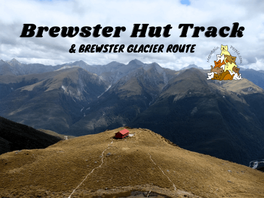
Brewster Track is an advanced tramping track through unabridged river, steep beech forest, and alpine terrains. The marked track ends at Brewster Hut where you can stay for a night (booking required), or have lunch before heading back down or towards the glacier. In winter and spring, the track is only suitable for experienced mountaineers with the right skills and equipment.
The route to Brewster Glacier is unmarked, guided only by cairns and goat tracks. It typically takes around 2 hours from Brewster Hut to Brewster Glacier, and another 2 hours back to the hut. You should only attempt to hike beyond the hut to the glacier if you are an experienced mountaineer or with an experienced group. Many people have had to be rescued from the area.
Fantail Falls Car Park to Brewster Track
9.55am: The track to Brewster Hut starts from Fantail Falls Car Park. The limited parking area wasn’t too small but there were many cars from day hikers, overnighters, and Fantail Falls visitors who parked there. Fantail Falls is just a couple minutes walk away, where I will drop by at the end of my hike back down.
9.56am: Brewster Track starts right away with its one and only river crossing. The unabridged Haast River is usually low (ankle height) on a dry day, but can quickly and drastically change by rainfall or snowmelt. Being able to cross the river at the start of your hike doesn’t mean it will be crossable when you return from your hike. Make sure to check the weather forecast before you start the hike. If rain is expected, postpone your trip to another day. Do not attempt to cross the flooded river. Be ready for delays with spare food, emergency shelter and clothing, just in case you need to wait for the river to drop.
Haast River to Brewster Track
10.03am: Enter the forest track marked by a big orange triangle.
(+3)10.06am: Right away a steep climb consistent for the next 30 minutes.
(+1)10.07am
(+19)10.26am
(+10)10.36am: A section of flat track as you climb onto the forest ridgeline and walk along it.
(+3)10.39am: Magical terrain
(+7)10.46am: Here comes more inclination.
(+3)10.50am
A tiny New Zealand native long-legged harvestman with a pair of huge claws!
(+19)11.09am: Rugged but beautiful forest terrains.
(+11)11.20am: Near the end of the forest section.
Over The Bushline
(+1)11.21am: Leaving the forest over the bushline.
(+5)11.26am: Constant uphill through snow grass bushes.
(+6)11.32am: Don’t forget to look back for an amazing 180° view.
(+5)11.37am: The first view of Mount Brewster (I think) with waterfalls flowing down the rock face.
(+1)11.38am
(+4)11.42am: Hike along the narrow ridge.
(+2)11.44am: First sight of Mount Brewster peak uncovered by the clouds.
(+7)11.51am: Approaching Brewster Hut, you will spot the toilet first before the actual hut.
Brewster Hut (~1,450m)
(+8)11.59am: Arrived at Brewster Hut!
My attention immediately shifted to the cheeky kea who’s screaming and trying to pry open the toilet vent.
These cute and cheeky kea are the world’s only species of alpine parrots, endangered and protected. They can fly from sea level to the alpine peaks. Kea are smart and they thrive in the harsh mountain terrains.
A few more kea roaming around the area. Look at their beautiful olive green feathers (and the bright red orange underwings from the previous photo)!
Bunk beds and kitchen / common room in Brewster Hut. Make sure to book in advance if you plan to stay here.
Brewster Hut to Brewster Glacier
12.34pm: After my lunch break in the hut, I headed off to Brewster Glacier. It is an unmarked route starting from the back of the hut, guided only by cairns (stacks of rocks) and some worn paths. Please ensure you have the right experience and make a good decision along the way whether to continue or not.
(+8)12.41pm: Brewster Hut looked too epic from here!
(+3)12.44pm
(+7)12.51pm: The route to Brewster Glacier begins with climbing snow grass covered hills…
(+15)1.06pm: …to rocky alpine terrains that barely show the worn paths.
(+2)1.08pm: An example of a cairn marker.
A glimpse of the glacier behind the clouds, over the hill.
(+11)1.29pm: Can you see the path?
(+13)1.42pm
Brewster Glacier (1,650m)
(+6)1.48pm: Voila, what a view! The bedrock around Brewster Glacier terminal lake, exposed by 20th Century ice retreat, is an exceptional example of how glaciers sculpt landscapes.
Now, to reach the glacier, the path goes down steeply through a slippery scree slope.
(+22)2.10pm: Once at the bottom, the path becomes easier to walk on but be careful of some slippery rock faces. Also, memorize the route you walk so you know the way back, as it can be confusing to find the path back to the hut.
(+4)2.14pm: A close look at the rock faces reveal scratch marks and arm-wide grooves. You’ll also find streamlined rock mounds which look smooth if looking down the valley, but rough if looking towards the glacier.
(+9)2.23pm
(+2)2.25pm
Ice cold glacier river created by meltwater.
(+3)2.28pm: Approaching the epic glacier!
Brewster Glacier is a relatively small cirque glacier, at 3 kilometers long (and receding).
A glacier cave
Hmm… Not gonna cross under it. (Look at the crack line on the left)
A group of climbers there recommended that I go and check out the right end side of the glacier, and I’m glad they did!
Epic shots of the wall of ice!
The Journey Back
Spotted more kea on my way back to the hut. A few of them were play-fighting like cats (belly up with kicking legs)!
4.46pm: Yet another epic view of the hut as I returned.
(+8)4.54pm: Back to the hut. Looked like a big overnight group had arrived.
(1h54m)6.48pm: Back to the river crossing just before the car park. Fortunately there wasn’t rain and the water level remained crossable.
Fantail Falls Track
The beautiful Fantail Falls is just a short walk away! You do need to wade in knee-deep (unless when it’s flooded, then you shouldn’t be in the water) cold water to reach the waterfall, but it felt so good after a long hike!
7pm: Back to the car park after a refreshing ice bath.
帖子有帮到您吗?在您的登山故事和帖子中标记 @meowtainpeople 吧!
*地球队长经过* 记住,请保护我们的环境,请勿破坏大自然。不要留下任何垃圾,只带回照片和回忆(如果可以的话,还可以捡走一些垃圾)。请在指定的路径上行走,并尽量保持在中间行走,以使裸露的土壤不会进一步扩散/腐蚀。与大自然融为一体吧 *飞走了*
支持本网站的附属链接:
透明度万岁!:以上链接是会员链接,如果您用此链接购买或预订的话,我可以赚取佣金, 而你也不会被收取额外费用。 我只推荐我使用的产品和公司。您的支持可以帮助我保持网站的运行,让我继续用心分享🙂
想在您的网站进行相同的联属网络营销吗?用这个 AccessTrade 平台链接 获取 RM5 奖励。

