

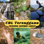
Taman Negeri Kenaboi / Kenaboi State Park is an awesome nature spot with so many points of interest, such as the separate waterfalls/river hikes to Lata Kijang, Lata Dinding and Jeram Berungut. Not to mention the famous hike to Gunung Besar Hantu, the highest mountain in Negeri Sembilan. Furthermore, camping activities are available at the campsite next to the river near the park office (no booking, walk-in only, first-come-first-served).

Lata Kijang waterfall is the shorter hike on the main trail. It’s around 4km one way, mostly on wide tarmac roads. It takes around 1.5 hours to reach the waterfall on foot. Alternatively, there are ‘gojek’ services offered by the orang asli on motorbikes to take you all the way to Lata Kijang (RM15 per ride – one way)
Lata Dinding waterfall is the longer but worthy hike. At around 10km one way, it takes around 3 hours from the parking to Lata Dinding. Lata Dinding features a huge wall of waterfall where you could stand at the bottom for a nice cold shower.
Jeram Berungut is nicknamed as The Lord Of The Rings river due to its beautiful ravine and river scene. This river hike is rather easy but 50% of the trip is walking in the river, around 30-45 minutes one way. The river is mostly shallow while some parts could be waist deep or higher. Avoid going here during rainfall or when rain is expected. Dangerous water surges can happen during heavy downpour and there are limited safe grounds along the river gorge. Lifejackets are recommended and they can be rented from the park office (RM5 each).

All the destinations require a permit (RM5 per person), which can be conveniently purchased at the park office or online at N9PAY platform. Only one permit (per day) per person is needed for all destinations in Taman Negeri Kenaboi. Guides are not mandatory for these destinations except for Gunung Besar Hantu (starting from Oct 2025).
Lata Kijang


About 20-30 minutes from the starting point to the junction to Lata Kijang.


After turning left at the junction towards Lata Kijang, the trail descends a bit before starting to ascend most of the way.


About 40 minutes from the junction to the high point with a wide paved road at the top.

10 minutes of downhill later, you’ll reach the ‘gojek’ drop-off/pick-up point before the waterfall.

Then, walk down the stairs.

Lata Kijang is just below.


Lata Kijang is a tall and slim waterfall with a mini pool gathered at the base, before flowing down the rocky wide shallow river.
Lata Dinding

Back to the junction, take the one on the right side to go to Lata Dinding / Gunung Besar Hantu. From here the tarmac road turns into dirt roads.

30-40 minutes later, you’ll reach another junction. Here you can choose whether to take the one on the right (same path to Gunung Besar Hantu via Kem Sungai Kering), or the one to the left (heading down to Sungai Kering and bypassing Kem Sungai Kering). Refer to this trail map for better understanding.


We took the path on the right and arrived at Kem Sungai Kering 20 minutes later. The trail to Gunung Besar Hantu goes to the right without crossing the river. Lata Dinding trail is on the opposite bank of the river (cross the river).


The trail to Lata Dinding after crossing the river at Kem Sungai Kering.

At the connected trail with the Sungai Kering alternative route.


Forest trails toward Lata Dinding. We found a few fallen forest chestnuts on the ground.


Crossing a stream.

Passing by a rumah orang asli (natives’ house).


More forest trails until Lata Dinding is spotted ahead.


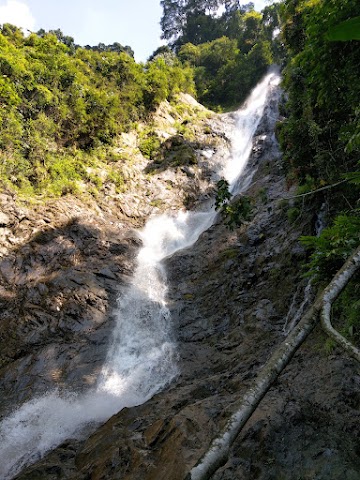
We arrived at the big wall of Lata Dinding waterfall!


This curtain of water sprinkling down the rock wall provides a nice cold shower.


Human for scale.
Jeram Berungut

Jeram Berungut hike starts at the river of Taman Negeri Kenaboi campsite area. The campsite is reached by crossing a hanging bridge behind the park office where you can rent a lifejacket.


Walk upstream on the river for a bit and you’ll find a trailhead on the opposite bank. Enter the trailhead and the entrance of Jeram Berungut is just around the corner.

Half of the distance to Jeram Berungut is on the forest trail.


After 15 minutes, we reached this signboard warning about not catching fish in this fish sanctuary. Here is the end of the forest trail where you go down onto the river bank.


The start of the river trail.


Some parts of the river are quite deep and may be difficult to swim against the fast currents. You can avoid these parts by walking at the side (either some land or shallow water are available).


Just keep going upstream along the river.

A beautiful driftwood.


You might notice both sides of the riverbanks are slowly turning into walls as you venture further. This is why it’s important to avoid going here when heavy downpour is expected. There aren’t many refuge spots if the flood happens suddenly.


At the end of the hike is where you’ll lay your eyes upon Jeram Berungut. The sudden views of the high walls of mossy green rocks made me feel like I was suddenly transported into a different world! I can understand why people compared this with The Lord Of The Rings scenery.


At the end of the narrowing walls is a little waterfall. It was quite difficult to swim through this deep narrow part as the current is the strongest here.


The return journey is the next fun activity. You can now float and let the river flow take you downstream!

As we took the Hulu Langat backroad back to KL, we discovered Ikan Bakar Sri Nikat and were surprised by the delicious food and chill kampung vibe.
帖子有帮到您吗?在您的登山故事和帖子中标记 @meowtainpeople 吧!

*地球队长经过* 记住,请保护我们的环境,请勿破坏大自然。不要留下任何垃圾,只带回照片和回忆(如果可以的话,还可以捡走一些垃圾)。请在指定的路径上行走,并尽量保持在中间行走,以使裸露的土壤不会进一步扩散/腐蚀。与大自然融为一体吧 *飞走了*
支持本网站的附属链接:
透明度万岁!:以上链接是会员链接,如果您用此链接购买或预订的话,我可以赚取佣金, 而你也不会被收取额外费用。 我只推荐我使用的产品和公司。您的支持可以帮助我保持网站的运行,让我继续用心分享🙂
想在您的网站进行相同的联属网络营销吗?用这个 AccessTrade 平台链接 获取 RM5 奖励。