
The historic Arrowtown and Macetown were once thriving gold mining settlements in New Zealand. As miners set up camps, sprouting a canvas town, it eventually turned into a town and was renamed as Arrowtown. Macetown is located 15 km further up the Arrow River among the mountains, far from civilization. And yet, Macetown was able to boom as a town, complete with a school, a church, and two hotels solely due to the mining industry.
As miners moved on, the town slowly died and by the 1930s, Macetown became a ghost town. As for Arrowtown, it remains as a small beautiful town next to the busy major city of Queenstown. Today, the relics and historic structures that remain between Arrowtown and Macetown narrate the gold rush and human history that changed New Zealand.
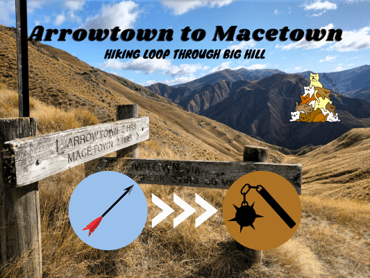
How To Go To Macetown
Despite being a town (in the past), there is no road that connects Macetown with the outside world. The direct path to Macetown is via the 4×4 / horse track (yup, people still ride horses in New Zealand tracks today). This track can be walked (3-4 hours one way), driven (4WD only), and rode (on a horse) or cycled (with a mountain bike). It involves 23 river crossings and they can be impassable during wet or winter seasons. For 4WD vehicles, it can be tricky to give way to the opposite traffic, as most parts of the track are narrow with steep drop-off down the river. Drivers also need to be mindful to reduce the erosion caused by their vehicles.
Some tours (affiliate link) offer 4WD and combo experience to Macetown:

The other ways to reach Macetown are via multiple choices of hiking tracks around Arrowtown region. As shown on the map, there are multiple tracks you can take to reach Macetown from Arrowtown. The duration depends on the paths you take, but generally it will take twice the time compared to the direct Macetown Road. Other than that, there is also Motatapu Track that connects Wanaka with Macetown (it is a 3-4 days track and part of Te Araroa Trail). You will find directional boards with maps at several junctions on the track, but you should also use a mobile hiking navigation app such as the free OutdoorActive app.
In this hike, I started from Arrowtown via the Westside trailhead to Bush Creek Junction to Eichardts Flat (Sawpit Gully Walkway Junction), took a side trip to German Hill, continued on to Big Hill Saddle (plus a side trip to Big Hill), and finally joining Macetown Road to Macetown. On my return route, I walked the main Macetown Road back to Arrowtown. (Click here to view the map, my track number references are 3a -> 3b -> 3c -> 3d -> 7e -> 7e return -> 7d -> 7c -> 7b -> 7a).
Hiking To Macetown


10.31am: The hike starts at the recreation reserve next to the main streets of Arrowtown, over a big parking area. A stream runs between the car park’s side and the main trails’ side. You will find a bridge to cross the stream further to the left.

After the bridge, refer to the signboard to find your trails.

The direct 4WD track to Macetown is to the right, but here I took the left towards Bush Creek Trail in order to do a longer exploration loop, where I will then return from the right.


(+9)10.40am: Stepping over the water pipe onto the trail along the stream. It was autumn season so the trail was covered with striking beautiful autumn leaves!

(+6)10.46am: At the Bush Creek Junction.


Follow the signage to Eichardts Flat (Sawpit Gully Track / Big Hill Track).

(+6)10.52am: A stretch of uphill slope. When I walk the Sawpit Gully Loop, I usually prefer coming down from this side due to this downhill path.

(+4)10.56am: Look at the red autumn trees!

(+7)11.03am: On the top of this small hill.

(+2)11.05am: The track goes downhill a little bit from here. (pic: some kind of fruit tree, probably not edible by humans)

(+6)11.11am: The track then goes uphill again through a section of forest.

(+8)11.19am: Arrived at Eichardts Flat. Straight ahead is the Big Hill Track. The Sawpit Gully Track is to the right.
Side Trip: German Hill (Sawpit Gully Track)


Since German Hill is nearby (just a short walk via Sawpit Gully Track from the junction), I decided to take a short side trip to the peak of the hill.

(+13)11.32am: It was a short but steep climb to the top. It’s worth the climb!
(I have a post on the full loop of Sawpit Gully Track and German Hill here)
Big Hill Track


(+9)11.41am: Back to the junction and continued the hike on Big Hill Track. This track is also part of the 3,000km Te Araroa Track.

(+7)11.48am

(+5)11.53am

A few parts of this track were quite muddy.

(+9)12.02pm: The track enters a section of forest for a short while.

(+2)12.04pm

(+7)12.11pm: There’s a turning that was a little confusing as there’s another dead end track straight ahead. Just keep in mind that you would make a wide u-turn to the right and keep an eye on the track across the gully.

(+18)12.29pm: Back out in the open.

(+9)12.38pm: You could see parts of Arrowtown and Lake Hayes from here.

(+13)12.51pm: Big Hill Saddle is just ahead. See the tiny human figure on the hill line on the left? He’s heading up to Brow Peak.
Big Hill Saddle & Side Trip To Big Hill Peak

(+5)12.56pm: Arrived at Big Hill Saddle. This is a cross junction to Brow Peak & Coronet Peak (left), Macetown (straight ahead), and Big Hill to Macetown Road via Hayes Creek Walkway (right, river crossing).

(+9)1.05pm: The top of Big Hill is just a short side trip from the saddle.


(+2)1.07pm: The panoramic views on Big Hill.

(+9)1.16pm: Back to the saddle junction, I continued on the Big Hill Track (left side of this signboard) towards Macetown.


(+5)1.21pm: This section involves a lot of walking through thick grassland. I slipped many times on these rigid strong grass because there’s no traction at all. Good thing the grassy ground was pretty nice to fall onto haha.


Don’t fall over on these spiky plants though!

Interesting plant with bright red fruits.

(+39)2pm: After a long walk on slippery grass, I found myself walking over the ridges.

And then, I saw wild goats! (invasive though, introduce by early European settlers to make New Zealand feels more ‘British’)

Heh, this one was sneaking behind the tall grass.

It’s quite a large herd hanging around.


They ran away as I passed through the track, but quickly returned to the same spot as I passed over their spot.


(+6)2.06pm

(+9)2.15pm: The track then heads down the valley and joins the Coronet Loop Trail, a backcountry mountain bike trail.


(+6)2.21pm


Found some skeletons beside the track.
Eight Mile Hut / Mt Soho Homestead (Derelict Hut)


(+5)2.26pm: Arrived at this odd rustic Eight Mile Hut (also known as Mt Soho Homestead – Derelict on the map). Not long ago a longdrop toilet was installed here. It’s possible to stay here for a night if you don’t mind the conditions (rats or possums may run around the roof all night long).


Onwards to Macetown. Expect to start crossing the streams and rivers multiple times from here.


(+11)2.37pm
Joining Into Macetown Road


(+5)2.42pm: The track eventually joins onto the 4WD track of Macetown Road. The track crosses the same Arrow River many times.


(+11)2.53pm: At one point, there’s a hiking track you can use to bypass the remaining river crossings on the 4WD track.

(+12)3.05pm: The hiking track provides a higher view of the Arrow River, while keeping your feet out of the chilly water.
Welcome To Macetown: A Gold Mining Ghost Town


(+12)3.17pm: Finally, I arrived at the ghost town.

(+7)3.24pm: The first side track (2 minutes) led me to the restored schoolmaster Joseph Needham’s Cottage.


You can take a look inside to see the rooms (blocked off by metal bars), fireplace, and the remains of a bed frame.

As I walked towards the ‘town center’, I noticed a track to the right down below, which is probably the campground area, and also the alternative path (some river crossings) I used for my return route.

(+13)3.37pm: Arrived at the ghost town center.

Here you will find multiple historic sites of building and terrace remains. Most only left the base of the building or tumbled stones.

The restored Macetown bakehouse.

3.46pm: There are some interesting stamping battery relics further away from Macetown: Anderson’s Battery (all-metal battery), Homeward Bound Battery (NZ’s grandest), United Goldfields Battery, and All Nations Battery. Unfortunately, I started my journey late and didn’t have enough autumn daylight to explore these battery sites. The Motatapu Track is the 3-4 days track to Wanaka that is part of Te Araroa Trail.

Instead of walking the road back through Macetown center, I went down to the tracks along the river. This involves crossing the river a few times before rejoining the main 4WD track back to Arrowtown.

(+4)3.50pm: Walking past what I believe was the camping ground in Macetown.
Macetown Track To Arrowtown


(+41)4.31pm: On the way back to Arrowtown via the direct route. I lost count of the times I crossed the cold river. Some crossings were over-the-knee deep and they can get impassable during flood or winter conditions.


At some river crossings there are tracks alternative to the 4WD road that can be walked on foot to avoid the river.

(+22)4.54pm: At this point there are no more necessary river crossings for walkers (a 4WD vehicle will still need to cross the river many times), as there are dry detour foot tracks or bridges along the way. Most of the time, however, you’ll be walking on the 4WD track.

(+34)5.25pm: Crossing Arrow Gorge Bridge.

(+50)6.15pm: A simple cross set up in memory of Matthew Hubber, a teen who fell off the cliff, possibly while mountain biking on Macetown Track.

(+7)6.22pm: The track goes underneath the water pipe between the pillars. As the sun sets, it got quite cold even with all this walking. Luckily I brought along my fleece jacket to keep me warm.

(+6)6.28pm: By the time I was crossing Norman Smith Bridge, it was already quite dark. Little did I know, a rare event of strong aurora was happening right then! (the only night I didn’t check the aurora alert as I was still out hiking!)

(+2)6.30pm: Carefully walking the narrow track in the dark with a steep drop-off to the side.

(+2)6.32pm: Arrived at another signboard + junction. A relief as the rest of the track is what I have walked before and am familiar with. Follow the flat track to Arrowtown. If you take the turn that climbs up, you’ll be walking the Sawpit Gully Track.


(+21)6.53pm: At last, I made it back safely to Arrowtown.
Macetown via Arrow River Track

11.01am: Let me run you through the beginning section of the main track to Macetown, if you opt to hike to Macetown via the direct route. Back to the starting point earlier, turn right to the trailhead to Macetown.

(+2)11.03am: On the way to the trailhead you’ll find some information sign boards about Macetown history.

(+1)11.04am: Here’s the starting point for Macetown – Arrow River Track / Macetown Road.


Now, if you are hiking on foot, take the trail on the left (following Arrow River Track), which is for walkers only. You’ll see the 4WD road (for 4WD vehicles, horse riders and mountain bikers) to the right, which also goes to Macetown.

(+5)11.09am: Follow the track along the pipeline. It’s my favorite spot to take a short walk during the autumn to see the bright red fallen leaves.

The 4WD Macetown Road runs below by the Arrow River.

(+5)11.14am: Remnants from the gold rush era can be spotted along the way.

(+2)11.16am: A beautiful viewpoint on Arrow River Track. Love the autumn colors!

(+8)11.24am: Passing over a mini waterfall.

(+5)11.29am: Norman Smith Bridge in sight. Cross the bridge to the opposite bank of Arrow River to continue towards Macetown. (I’ll stop here since you’ve seen the track from my return journey walking back from Macetown.)
帖子有帮到您吗?在您的登山故事和帖子中标记 @meowtainpeople 吧!

*地球队长经过* 记住,请保护我们的环境,请勿破坏大自然。不要留下任何垃圾,只带回照片和回忆(如果可以的话,还可以捡走一些垃圾)。请在指定的路径上行走,并尽量保持在中间行走,以使裸露的土壤不会进一步扩散/腐蚀。与大自然融为一体吧 *飞走了*
支持本网站的附属链接:
透明度万岁!:以上链接是会员链接,如果您用此链接购买或预订的话,我可以赚取佣金, 而你也不会被收取额外费用。 我只推荐我使用的产品和公司。您的支持可以帮助我保持网站的运行,让我继续用心分享🙂
想在您的网站进行相同的联属网络营销吗?用这个 AccessTrade 平台链接 获取 RM5 奖励。