Rakiura Track is currently the shortest Great Walk in New Zealand, located on Stewart Island, the third largest island in New Zealand. With a distance of a 32km loop and the highest elevation of 200m, it can be easily completed in a couple days, or even in one day, but it’s always good to spend a little more time on the track to enjoy nature and to spot wildlife.

You can start your Rakiura Track hike at either trailhead. I started mine at Lee Bay road end in the afternoon, slept at Port William Campsite, and completed the track in 1.5 days. However, I would recommend you to at least have a night at North Arm Hut / Campsite for the biggest chance of spotting wild kiwi birds in that area.
How To Get To Stewart Island
There are two ways to get to Stewart Island: By taking a small plane from Queenstown or Invercargill, by helicopter from Bluff, or by taking a ferry from Bluff.
I took the ferry (there is only one ferry provider for Stewart Island, passengers only, not for cars) from Bluff ferry terminal and it took about 30 minutes to arrive at Stewart Island. There is a paid car park facility near the ferry terminal, but because I stayed at The Eagle’s, the owner let me park my car at the free car park in front of the hotel.
Rakiura Track Great Walk Booking
All Great Walks in New Zealand require booking in advance for the huts and campsites. Off-site camping is not allowed on the Great Walk tracks. Here is the online booking site for all Great Walk accommodations. Lookout for the opening dates of bookings for each season as the popular great walks tend to get fully booked pretty fast.
If the slots are fully booked and you are flexible with your dates, you can run through the site’s booking calendar regularly to lookout for any new slots, as people often cancel their booking days/weeks/months before the trip. Don’t simply book and cancel though, here are the cancellation fees in detail.
Things I packed for Rakiura Track
Tip: Get your trekking food supply ready before arriving at Stewart Island, as there is only a limited variety of supplies you can get from the small stores in the island.
- 40L Hiking Backpack from Decathlon with rain cover and a large strong rubbish bag lined inside as additional water protection (plus a separate sackpack to carry my tent)
- Forclaz Trek 100 三季圆顶帐篷 (比大多数帐篷重,但抗风性和防水性非常好)
- PTT Outdoor 的 HIGH PEAK 便捷旅行睡袋 (首次购买最低 RM100 即可优惠 RM10,优惠码“MEOW”,仅限马来西亚境内)
- TOMSHOO sleeping bag liner
- 充气床垫和枕头
- Quechua 登山雨衣
- Sun Protect 长袖跑步 T 恤 + Quechua Hiking Fleece Jacket + 速干跑步短裤 + Kiprun 跑步袜 (for the day)
- Ski base layers top + pants + warm hiking socks + gloves from Decathlon (as sleepwear)
- Extra 羽绒服 (didn’t use but important to bring, just in case)
- Adidas Kampung (not from Adidas, Malaysia’s trusty rubber hiking shoes)
- Flip flops (for walking around campsites / huts)
- Sun hat (I didn’t use it as the track is under the tree canopy most of the time, except for the short beach track)
- 急救箱,指南针和哨子
- 充电头灯 (red light recommended for kiwi bird spotting)
- Phone (with booking confirmation pdf file), powerbank & charging cables
- Food and snacks (sandwiches, muesli, trail mix, energy bars), paper towels, rubbish bags
- Water bottles (2L)
- HydroBlu 轻型滤水器
- CuloClean 便携式射水头, some toilet paper
- Toothbrush, toothpaste, hand sanitizer, soap, hairbrush
- Fire lighter (just for emergency, not needed if staying on campsite as you can’t light a fire. Useful for lighting fire wood if staying in a hut)
- 折叠剪刀
Before you go, check the weather forecast for Rakiura National Park. Without other landmass as a barrier, Stewart Island, located in the ‘roaring forties’, is very exposed to the strong Westerlies, and the freezing Southerlies coming from Antartica. Weather on the island can be extreme when these winds occur.
Rakiura Track - Day 1
Ferry Terminal / Oban Town to Lee Bay Trailhead - 5km
11.10am: The walk to Lee Bay trailhead from the ferry terminal or the town is around 5km. It takes about 1 hour+ on foot.
(+66)12.16pm: Arrived at Lee Bay trailhead.
Lee Bay to Maori Beach Campsite - 4.1km
(+5)12.21pm: Trees sculptured by the strong winds.
(+6)12.27pm: Flat to mild elevation along the shaded coast track.
(+14)12.41pm
(+2)12.43pm
(+3)12.46pm: At low tide, it is possible to walk around the beach and join back to the track further up. I took the high tide route.
(+24)1.10pm
(+18)1.28pm: Another high/low tide route option just before Maori Beach Campsite. I took the low tide route, crossing the creek to head directly to Maori Beach.
(+4)1.32pm: Maori Beach Campsite
(+3)1.35pm: A short few minutes side trip from the campsite to some historic sawmill relics.
Maori Beach Campsite to Port William Hut / Campsite - 4km
(+11)1.46pm: Since it was low tide, I took the sandy beach route towards the foot bridge of Rakiura Track.etur adipiscing elit. Ut elit tellus, luctus nec ullamcorper mattis, pulvinar dapibus leo.
(+10)1.56pm: And then, I saw a wiggling sausage in the distance.
It’s a giant sea sausage! (a big seal resting on the beach)
(+2)1.58pm: Arrived at the foot bridge, crossing a tidal stream into the hill forest.
(+10)2.08pm: Trees weirdly mended together, with more small trees growing on top of them.
2.08pm: A small hill to climb, about 100-ish of elevation.
(+8)2.16pm: A lump of rock with trees growing around it?
(+8)2.24pm: At the junction to Port William Hut / Campsite, where I will stay for a night. I had to backtrack to this junction for my onward trek to the rest of the Rakiura Track.
(+3)2.27pm
(+5)2.32pm: It’s a downhill from the small hill I’ve just climbed (and uphill for tomorrow’s walk back to the junction point).
(+24)2.56pm: Arrived at Port William Campsite, where I set up my tent for the night.
Port William Hut is a few minutes further away from the campsite.
A wharf between the hut and the campsite.
At night, I did not hear any kiwi calls. My guess is due to the sandy beach area, it is not a preferred place for kiwis to find food (earthworms). However, I got woken up by loud footsteps from a deer (non-native pest) running at the campsite among the tents.
Rakiura Track - Day 2
Port William Hut / Campsite to North Arm Hut - 13km
7.59am: Packed up and left the campsite after breakfast.
(+25)8.24am: Backtracked to the junction and headed towards North Arm Hut.
(+17)8.41am: The track passed by remnants of milling activities along the old tramlines.
(+22)9.03am: The start of the well-known muddy sections between Port William and North Arm Hut. It got muddier and deeper as I hiked further in the next hour, even though it was a dry week. Imagine hiking here during wet periods, I’ve seen photos of people waist-deep in mud!
(+5)9.08am
(+4)9.12am
(+12)9.24am
(+40)8.04am: Suddenly, I spotted a deer standing right on the track. I think we spotted each other at the same time.
(+2h18m)10.22am: The halfway point between the two huts.
(+1h54m)12.16pm: Arrived at North Arm Campsite shelter.
This place would be a great spot to encounter kiwi birds when it gets dark. I met a group of hikers coming from North Arm, and they saw six kiwis the night before!
I was very disappointed to find a feral kitten. Cute, but these ferocious feral cats brought in and left by humans are very bad for the ecosystem in New Zealand. A single feral cat can and will hunt many endangered native birds (including kiwi) on a daily basis. I heard that feral cats have been an ongoing problem on the island for quite some time.
Tenting spots around North Arm Campsite.
North Arm Hut is a few minutes further away from the main track.
North Arm Hut / Campsite to Fern Gully Trailhead Exit
12.46pm: Back to the main track after lunch break to continue the hike.
(+41)1.27pm: The basic Sawdust Bay Campsite.
(+60)2.27pm: A quick side trip to Gallon’s Sawmill historic site. Nothing much to see here except for a stream where you could find a trace of a small man-made earth dam if you look hard enough. There are some sawmill relics further away but it seems that the track has been closed off from the public.
(+20)2.47pm: Side trip to Kaipipi Bay.
(+33)3.20pm
(+16)3.36pm: P.s. Halfmoon Bay refers to Stewart Island’s main settlement area (Oban), so it’s the right way if you are heading to the Fern Gully road end exit.
(+7)3.43pm: Exited Rakiura Track via Fern Gully Trailhead.
Still some distance to walk to the town.
Fern Gully Trailhead to Oban Township - 2km
(+28)4.11pm: About half an hour later, I arrived at Oban, which then I checked in at Stewart Island Backpackers to have a night’s rest after celebrating New Year’s Eve dancing outside a hotel bar near the beach with a few people I met at the backpackers and a bunch of stranger.
Usually, it is quite possible to spot kiwi birds roaming around the township, especially around the rugby field looking for worms. However, probably due to the New Year’s Eve fireworks scaring them away, I did not encounter any kiwi.
A little epilogue: A bit disappointed with the quietness of the forest as Stewart Island was heavily marketed as a predator-free birds’ paradise. It was said to be an island filled with deafening songs of the native birds, but during my time on Rakiura Track, it was dreadly lacking in bird life. New Zealand’s native wildlife population really got hit hard by the introduced pests and predators.
[Photo above is a Tūī, New Zealand native bird with its signature white throat tuft and dynamic vocal range]
Ulva Island (An Open Island Sanctuary)
Fortunately, Ulva Island presented me hope for the conservation efforts. It is a small island close to Stewart Island, and a nature sanctuary open to the public. The island offers a predator-free environment for native birds and flora to thrive in its habitat. There was a brief re-invasion by Norway rats in 2010, and another one recently around August 2023 (probably swam in from Stewart Island). The Department of Conservation worked hard and brought in pest detection dogs, and they did a great job to prevent mass losses of native habitats, but events like this show us the vulnerabilities and how easily biosecurity standards can be breached. The least we can do is to check our bags, items and footwears for weed seeds, rodents and other invasive species, before departing to the sanctuary.
You can travel to Ulva Island by taking a water taxi, around $30 (return) per person. You can enquire and check the water taxi schedule at Oban Visitor Center. The water taxi departs from Golden Bay Wharf and it takes about 10 minutes to arrive at Ulva Island.
Ulva Island is full of birdlife. It is a great place to have a taste of how a recovering predator-free New Zealand would look like.
Red-crowned parakeet / Kākāriki
A Kākā – large New Zealand native parrot
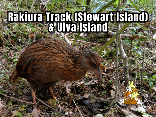
The cheeky Weka! A New Zealand native flightless bird known for its feisty and curious personality. This one wasn’t afraid of humans and casually digging the ground around me for food.
Oystercatchers along the shore.
A seal sleeping on the beach.
More cheeky Wekas!
Kererū – New Zealand’s plum pigeons, who often feed on fermented fruit until they are drunk and fall off the trees.
A curious South Island Robin.
Good Food On Stewart Island
Being an isolated island with limited supplies, Stewart Island surprisingly contains some pretty excellent eateries. Check out Kai Kart for New Zealand’s best fish & chips和 Fin & Feather Eatery for its island famous boozy donuts and unique gourmet menu!
帖子有帮到您吗?在您的登山故事和帖子中标记 @meowtainpeople 吧!
*地球队长经过* 记住,请保护我们的环境,请勿破坏大自然。不要留下任何垃圾,只带回照片和回忆(如果可以的话,还可以捡走一些垃圾)。请在指定的路径上行走,并尽量保持在中间行走,以使裸露的土壤不会进一步扩散/腐蚀。与大自然融为一体吧 *飞走了*
支持本网站的附属链接:
透明度万岁!:以上链接是会员链接,如果您用此链接购买或预订的话,我可以赚取佣金, 而你也不会被收取额外费用。 我只推荐我使用的产品和公司。您的支持可以帮助我保持网站的运行,让我继续用心分享🙂
想在您的网站进行相同的联属网络营销吗?用这个 AccessTrade 平台链接 获取 RM5 奖励。

