
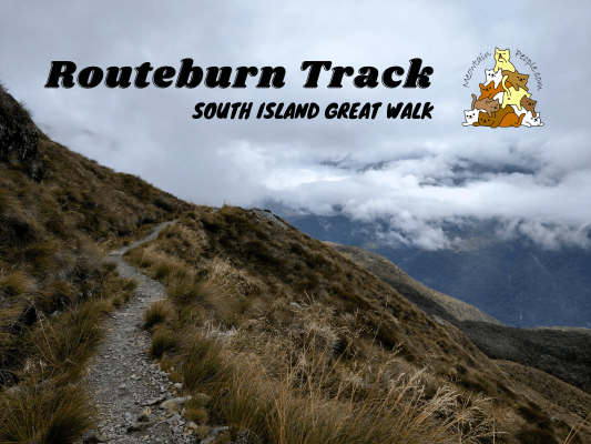
Routeburn Track is one of the Great Walks in New Zealand. It’s an ultimate alpine journey that weaves through both Fiordland National Park and Mount Aspiring National Park. This 33 kilometers track takes you over spectacular mountain ranges, valleys, alpine gardens, and epic waterfalls. The great walk season starts from mid November to late April. Outside of this season, facilities are greatly reduced, bridges are removed and there are more hazards such as avalanches, floods and short daylight hours, and should only be attempted by experienced and well-equipped people.
Routeburn Track Great Walk Booking
All Great Walks in New Zealand require booking in advance for the huts and campsites. Off-site camping is not allowed on the Great Walk tracks. Here is the online booking site for all Great Walk accommodations. Lookout for the opening dates of bookings for each season as the popular great walks tend to get fully booked pretty fast, Routeburn Track is one of the most popular ones.
If the slots are fully booked and you are flexible with your dates, you can run through the site’s booking calendar regularly to lookout for any new slots, as people often cancel their booking days/weeks/months before the trip. Don’t simply book and cancel though, here are the cancellation fees in detail.
Just like Milford Track, those who want to stay in luxury private lodges (separate from DoC huts above) inclusive with meals, guide, and shuttle transport and don’t mind paying the cost, they can book the package with Ultimate Hikes.
Routeburn Track Transportation
Routeburn Track can be walked from either end: Routeburn Shelter Car Park 或 The Divide Shelter Car Park. However, both ends are 324 kilometers apart via roads as they go a big loop around the vast mountains. Unless you are doing a return track back to the start (if huts/campsites are available to book), you would need to organize your transport back to your car at the other end, or back to the city.
The most budget way is to find someone in advance who is walking the track on the same days with you but via the opposite direction. Plan a point to meet on the track to do a key-swap (a common practice in New Zealand) and drive each others’ car to the agreed location after the hike.
The easiest option is to book a shuttle service like I did with Fiordland Outdoors. They arranged with multiple transportation service partners without extra costs. With that, I hopped onto Queenstown’s Info & Track Bus to Routeburn Shelter to start my great walk. At the end of my hike, Fiordland’s Cheeky Kiwi Bus (my favorite transport operator!) picked me up from The Divide Shelter back to Queenstown. You can also get picked up / dropped off in Te Anau.
Things I packed for Routeburn Track
- 40L Hiking Backpack from Decathlon with rain cover and a large strong rubbish bag lined inside as additional water protection (plus a separate sackpack to carry my tent)
- Forclaz Trek 100 三季圆顶帐篷 (比大多数帐篷重,但抗风性和防水性非常好)
- PTT Outdoor 的 HIGH PEAK 便捷旅行睡袋 (首次购买最低 RM100 即可优惠 RM10,优惠码“MEOW”,仅限马来西亚境内)
- TOMSHOO sleeping bag liner
- 充气床垫和枕头
- Quechua 登山雨衣
- Sun Protect 长袖跑步 T 恤, 速干跑步短裤 + Kiprun 跑步袜 (for the day)
- Quechua 登山抓绒夹克
- Ski base layers top + pants + warm hiking socks + gloves from Decathlon (as sleepwear)
- Extra 羽绒服 (didn’t use but important to bring, just in case)
- Adidas Kampung (not from Adidas, Malaysia’s trusty rubber hiking shoes)
- Flip flops (for walking around campsites / huts)
- Sun Protection: Sun Hat, Sun Glasses (Quite some exposed parts of the track, but I didn’t use them as it was cloudy the whole time)
- 急救箱,指南针和哨子
- 充电头灯 (red light recommended for kiwi bird spotting)
- Phone (with booking confirmation pdf file), powerbank & charging cables
- Food and snacks (wraps, tuna spread, muesli, mixed nuts, energy bars), paper towels, rubbish bags
- Water bottles (1-2L)
- HydroBlu 轻型滤水器
- CuloClean 便携式射水头, some toilet paper
- Toothbrush, toothpaste, hand sanitizer, soap, hairbrush
- Fire lighter (just for emergency, not needed if staying on campsite as you can’t light a fire. Useful for lighting fire wood if staying in a hut)
- 折叠剪刀
Before you go, check the weather forecast for Routeburn Track. Located in the ‘roaring forties’, the alpine terrain is very exposed to the strong Westerlies, and the freezing Southerlies coming from Antarctica. Weather on RouteburnTrack can be extreme when these winds occur.
Routeburn Track - Day 1
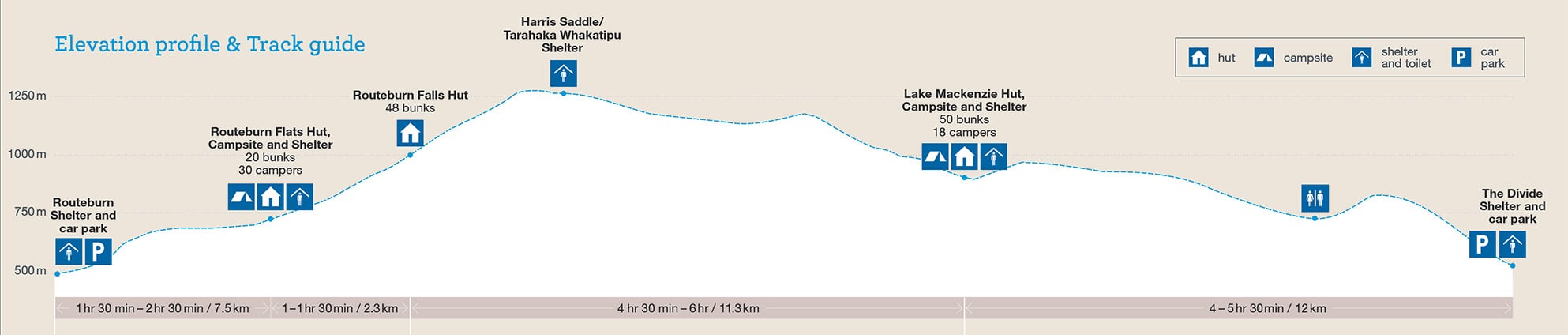
Routeburn Shelter to Routeburn Flats Hut (7.5km)

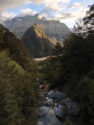
12.45pm: After a 40-minute ride from Queenstown center, the bus shuttle dropped me off at Routeburn Shelter.

12.46pm: The Route Burn River.
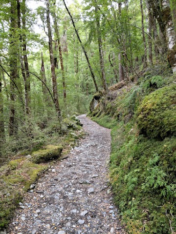
(+30)1.16pm: It begins with a gentle hike up along Route Burn river through beech forest.

(+7)1.23pm: Bridal Veil Falls

(+9)1.32pm

(+15)1.47pm: A toilet by the track.
Side Trip: Forge Flat


(+7)1.54pm: A quick side trip to Forge Flat.


It’s one of the only spots you’ll get to access the crystal clear river.

(+8)2.03pm: Back to the main track.
(+25)2.28pm: The track opens up for a moment before reentering the beech forest.

(+10)2.38pm: The junction to Routeburn Flats Hut and Campsite, where I spent my first night.
Routeburn Flats Campsite

(+5)2.43pm: I first arrived at Routeburn Flat Hut.

Flush toilets (a luxury!) and sinks outside the hut.


A South Island Robin.

The campsite is almost 200 meters further away from the hut. There are two shelters and two toilets, plus a few benches at some tent sites.

No one else was here yet so I got to pick the site for my tent first.

What a view!

Took a nap while it’s nice and sunny. There were some sand flies around so I didn’t sit outside for long. The warden from the hut came by in the evening to check campers’ permit and attendance. The night was calm and quiet.
H2
Routeburn Flats Hut to Routeburn Falls Hut (2.3km)

8.05am: After breakfast and tent packed, I left the campsite and back to the junction at the main track.

(+4)8.09am: It’s quite a climb towards Routeburn Falls Hut and here starts the longest stretch of steep incline of the whole track.

(+17)8.26am


(+5)8.31am

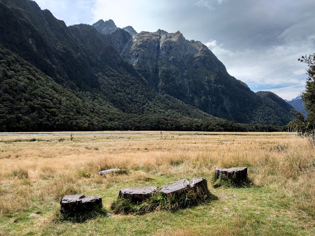
(+1)8.32am: Impressive view of Humboldt Mountains.

(+6)8.38am: Rock fall area

(+9)8.47am: Some steep rocky tracks to climb.

(+6)8.53am: Arrived at Routeburn Falls Hut. There is no campsite here. The private luxury lodge is two minutes further along the track.
Routeburn Falls Hut to Lake Mackenzie Hut (11.3km)


(+4)8.57am: Past the hut is the viewpoint of Routeburn Falls.

(+3)9am: As you continue on, you will pass along Routeburn Falls cascades.

(+4)9.04am: The track continues up towards Harris Saddle.


(+6)9.10am: The track then takes you up to an open basin.

(+4)9.14am: A layer of thick clouds covered the sky.

(+3)9.17am: The sunlight occasionally shined through, turning the scenery into golden hues.


(+2)9.19am: After some flat-ish track, you’ll come across a hill and the track zigzags up to the top.

(+3)9.22am: Looking back at the direction I came from as I climbed the hill.

(+6)9.28am: After the hill, the track becomes flat-ish again, before turning into a gentle uphill track.

Some cascades / waterfalls in the distance. Probably the outlet of Lake Harris.
Lake Harris

(+26)9.54am: Lake Harris comes into view.

(+10)10.04am: There seems to be a side track that leads to the lake, but I missed it as the track junction was a small un-signposted opening.

From here the track weaves above the lake. It can get quite narrow at some places, and sometimes a little tricky to give space to the opposite traffic.

(+4)10.08am
Looking back towards the lake outlet and valleys.


(+5)10.13am
Harris Saddle Shelter + Side trip: Conical Hill

(+11)10.24am: Shortly after crossing Harris Saddle, the highest point on the main track (1,255m), I arrived at Harris Saddle Shelter (another shelter beside it is for the private tour). The saddle is where you will feel the first full exposure of any Westerly weather. Wind can be strong and temperature can be much colder. The shelter is a good place to take a break from the elements and use the toilet.


The track to Conical Hill side trip is just behind the shelter. It was quite foggy at the time and I was considering whether it’s worth the 1-2 hours climb to see only fog.

10.35am: After a toilet break, the fog seemed a little better. I decided to take the side trip to Conical Hill since I have enough spare time to reach my next campsite. I left my backpack in the shelter and brought along a small bag with snacks, water, extra coat and raincoat, just in case the weather changed before I got back down.


(+6)10.41am: The track is steep and can be quite slippery.

(+17)10.58am: Near halfway point, there’s a nice lookout to Lake Harris below.


(+1)10.59am: Follow the pole markers to Conical Hill peak.

(+11)11.10am: This rock looked like an eagle perched on the hillside.

(+4)11.14am: Views from the corner of the hill come into view as you climb higher.

(+20)11.34am: At last, I arrived at the peak of Conical Hill. It was still very foggy but at least the layer of clouds was slightly below the peak, giving off a kind of mystical scene. On clear days you could see the beautiful Hollyford Valley, Lake McKerrow and even the ocean from here. It looked like some serious fog was on its way so I didn’t linger long at the peak.
Resuming on Routeburn Track

12.40pm: After my lunch break back in Harris Saddle Shelter, I resumed my hike on the main track to Lake Mackenzie Campsite. Here you will begin descending and crossing the Hollyford Face. The narrow track runs along the mountains’ side.

(+19)12.59pm: The junction to the challenging route of Deadmans Track.
Keep an eye on an array of alpine plants, and the expansive views over the Darran Mountains.

(+13)1.12pm

(+27)1.39pm: It got foggy.

(+7)1.46pm: Crossing a bridge over the Potters Creek

(+21)2.07pm: After around 3.5km, the track takes a sharp turn and up over the final ridge.

Right at the sharp turn you’ll get the first sight of Lake Mackenzie, the hut and lodges down below.

(+5)2.12pm: After walking over the ridge, the track zigzags down towards the lake.

(+34)2.46pm: As you descend, the track reenters the enchanting mossy forest.


(+26)3.12pm

(+5)3.17pm: Arrived at Lake Mackenzie Hut!

(+3)3.20pm: The enchanting Lake Mackenzie is just a short walk away.

(+13)3.33pm: The trees along the side track to the campsite and Split Rock Track.
Lake Mackenzie Campsite

(+8)3.41pm: Finally, I arrived at my second night’s campground at Lake Mackenzie Campsite. There are multiple camp spots like this, surrounded by the bush with an entrance for some privacy at your own space.

Poof! The ground mat is large enough to be shared with your small group of friends (2-3 tents). As usual, the hut warden will come by in the evening for attendance and permit checks. It was forecasted to rain that night and it did.
Side Trip: Split Rock Track

4.04pm: From the campsite, the Split Rock Track is a 25-minute return side trip (1 hour from the hut) to a, as you guessed, a split rock.


(+7)4.11pm: Passing by a stream.

(+4)4.15pm: And also passing by the Northeast edge of Lake Mackenzie.

(+2)4.17pm: At the end of the trail, look to your right to find the big Split Rock.


Routeburn Track - Day 3
Mackenzie Hut to The Divide Shelter (12km)

8.43am: The next morning, I packed my tent at the campsite, walked 10 minutes back to the hut and continued my last day of great walk on the main track.

The luxury private lodge can be spotted a minute later.


(+23)9.06am: The track begins with the climb through thick beech forest.

(+16)9.21am: Up to the bush line and then start to slowly descend.

(+11)9.32am: An open grassy area called the ‘Orchard’, dotted with ribbonwood trees.

(+2)9.34am

(+17)9.51am: A toilet is available here.

(+8)9.59am: Passing a small waterfall. It had been raining the whole night so many of the streams and waterfalls crossing the track were bigger than normal.

(+15)10.14am: Here is the junction between the main track via Earland Falls, and the detour track that avoids the waterfall during flood.
Earland Falls


(+3)10.17am: Arrived at the epic Earland Falls! Be prepared to get a continuous strong spray of water mist when passing through.

The rain had definitely powered-up the waterfall. Luckily it wasn’t too strong and the track wasn’t flooded.

On a calm summer day, it would be a great spot for a dip.

(+7)10.24am: Continue on, some parts of the track after the waterfall had some streams flowing over it. Due to the heavy rain, some were quite wide and fast-flowing. I had to wet my feet to cross them.


(+17)10.41am: Crossing another mini waterfall.

(+54)11.35am: Arrived at Lake Howden. A hut here was destroyed by storm damage in 2020.
Side trip: Key Summit Track


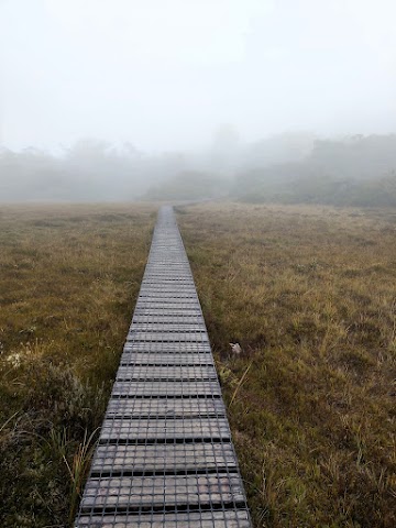
(+19)11.54am: The side track climbs to Key Summit Alpine Nature Walk. While zigzagging up the track, the strong Westerlies wind was blowing horizontal rain on me.

(+14)12.08pm: A toilet near the top.

(+2)12.10pm: Here starts the 30-minute circuit at the nature walk on Key Summit. It’s a popular track for day-walkers coming in from The Divide.


The walk features sub-alpine shrublands, alpine tarns and bogs. On calm days, birds and insects are active and commonly seen.

During the last ice age about 14,000 years ago, a huge glacier flowed down the Hollyford Valley and overtopped Key Summit by 500 meters. You would be able to see the panoramic views over the Humboldt and Darrans Mountains on a clear day.
5-minute track to Lake Marian lookout, but it was too foggy to see anything.


(+36)12.44pm: Back down to Routeburn track.

(+46)1.30pm: At last, I completed the Routeburn Great Walk and exited at The Divide Shelter, soaked but happy! I waited here for the shuttle bus to take me back to Queenstown.
帖子有帮到您吗?在您的登山故事和帖子中标记 @meowtainpeople 吧!

*地球队长经过* 记住,请保护我们的环境,请勿破坏大自然。不要留下任何垃圾,只带回照片和回忆(如果可以的话,还可以捡走一些垃圾)。请在指定的路径上行走,并尽量保持在中间行走,以使裸露的土壤不会进一步扩散/腐蚀。与大自然融为一体吧 *飞走了*
支持本网站的附属链接:
透明度万岁!:以上链接是会员链接,如果您用此链接购买或预订的话,我可以赚取佣金, 而你也不会被收取额外费用。 我只推荐我使用的产品和公司。您的支持可以帮助我保持网站的运行,让我继续用心分享🙂
想在您的网站进行相同的联属网络营销吗?用这个 AccessTrade 平台链接 获取 RM5 奖励。