
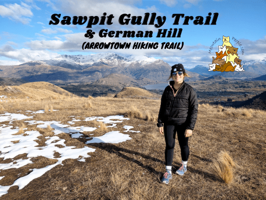
The Sawpit Gully Trail is an easy-moderate hiking loop starting from Arrowtown. The 2-3 hours loop trail offers a variety of scenery, including the Arrow River, gold mining relics, creeks, mountain ranges, and open grassland. At the Northern half-point of the loop, a steep but short climb up the German Hill presents a breathtaking panoramic view of the mountains, lakes and towns below.
Sawpit Gully Trail Starting Point

Just like the Macetown hiking loop, the Sawpit Gully loop trail starts and ends 这里 (after crossing the stream via a little bridge from the car park). You can hike the loop in both directions, but doing it counter-clockwise (start from the right) is easier because it’s less steep to ascend.

The trail is not shown on Google Maps so you should download some trail apps such as the free OutdoorActive app to refer to as you hike.


1.41pm: At the end of the walkway after you turn right are the trailheads to Sawpit Gully Trail, Arrow River Trail, and Macetown Road. Take the one on the left. Notice how the scenery (colors) look different in both photos? The left one was taken during the colorful Autumn season, the other one was taken early winter for this hike.

(+3)1.44pm: Walk the trail along the metal pipe.

Along the rock cliffs, you’ll find interesting thin layered schist rock faces to your left. Flakes of broken rock piles up at the side of the trail.

(+13)1.57pm: Crossing this mini stream waterfall.


(+3)2pm: One of the several Arrow River viewpoints. Compared to autumn (photo on the right), the winter scene looked much duller but still a great walk.
Sawpit Gully Walkway Junction


(+1)2.01pm: At the signboard showing the trail map, take the trail up the hill.

(+1)2.02pm


(+1)2.03pm: After a quick steep climb, there’s a ‘weta motel’ installed on a tree trunk. We’re in luck, there’s a weta inside!


(+11)2.14pm: After some flat walking, there’s a viewpoint corner, looking back to where we came from.

You could see the Arrow River and trail below. Far ahead is the town (Arrowtown) and the Remarkables mountain ranges.

(+6)2.20pm: While walking on the trail we saw a special looking tree up in the bush. The big tree is growing on this large schist boulder!


(+9)2.29pm: Continue on the trail. Both photos were taken at the same location, two weeks apart in early winter. See the snow in the second photo?

(+6)2.35pm: Some downhill through the narrow trail.

(+7)2.42pm: Some small streams crossing (possible to keep your feet dry by hopping over or stepping on rocks).


(+9)2.51pm: No snow VS with snow on trail

(+1)2.52pm: Some open snow grass fields.

(+8)3pm: From here it starts going uphill again,

(+5)3.05pm

(+2)3.06pm: Beginning the ascent to German Hill.

(+4)3.10pm: A bench at the halfway point.
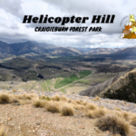
German Hill


(+7)3.17pm: At the top of German Hill!


Same peak but with snow two weeks later.


Some shots taken by my wildlife photographer friend from Chile. Maybe I’m the wildlife here…

With such a nice view plus a good not-too-long-and-not-too-short beautiful and quiet trail, no wonder Sawpit Gully Trail was my top trail to hike when I was living in Arrowtown!

A memorial plate of Maurice Lloyd Ryan, a New Zealand cricket player.
Sawpit Gully Trail - Back to Arrowtown via Big Hill Walkway / Eichardts Flat Junction

3.50pm: Shortly after coming down from German Hill is the Eichardts Flat or Sawpit Gully Walkway Junction. There’s a map here on the trail for hikers to refer to.

From here, it’s all downhill to Arrowtown.


(+6)3.56pm: A brief walk through patches of forest.

(+10)4.06pm: A small hilltop lookout point with a storage box.


(+4)4.10pm: Continuous downhill. This is why going anti-clockwise on Sawpit Gully Trail is easier, compared to coming up from here.

(+11)4.21pm: Come down to Bush Creek Junction and cross the bridge. Follow the sign to Arrowtown.

(+6)4.27pm: Pleasant walk along the stream.

(+3)4.30pm: All flats from here. Only 7-10 minutes to the car park / exit.
帖子有帮到您吗?在您的登山故事和帖子中标记 @meowtainpeople 吧!

*地球队长经过* 记住,请保护我们的环境,请勿破坏大自然。不要留下任何垃圾,只带回照片和回忆(如果可以的话,还可以捡走一些垃圾)。请在指定的路径上行走,并尽量保持在中间行走,以使裸露的土壤不会进一步扩散/腐蚀。与大自然融为一体吧 *飞走了*
支持本网站的附属链接:
透明度万岁!:以上链接是会员链接,如果您用此链接购买或预订的话,我可以赚取佣金, 而你也不会被收取额外费用。 我只推荐我使用的产品和公司。您的支持可以帮助我保持网站的运行,让我继续用心分享🙂
想在您的网站进行相同的联属网络营销吗?用这个 AccessTrade 平台链接 获取 RM5 奖励。