
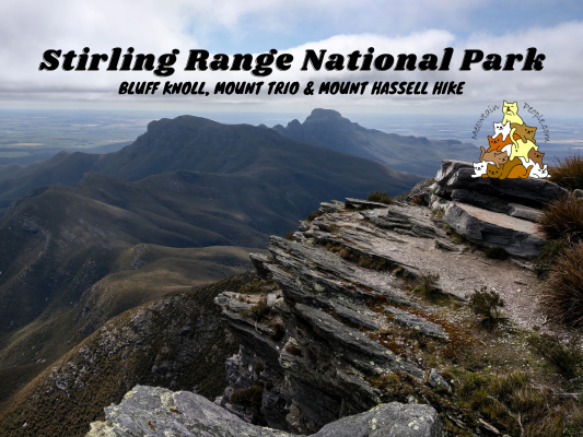
The only major mountain range in the southern area of Western Australia lies in the Stirling Range National Park. With multiple peaks ranging from 783 meters to 1,095 meters, the park offers a range of spectacular, multi-hour hikes.

The peaks or hiking trails in Stirling Range National Park include:
- Bluff Knoll (1,095m) (6km return, 2-4 hours): The highest peak and the most popular trail in the park.
- Toolbrunup Peak (1,052m) (4km return, 3-4 hours): The second highest peak in the park with a steep rocky section near the top.
- Mount Trio (865m) (3.5km return, 2-3 hours): Climb three peaks in one go connected by a plateau.
- Mount Magog (865m) (7km return, 2-4 hours): Hike through tall wandoo woodland to views of open country and thick bush.
- Mount Hassell (827m) (3km return, ~3 hours): Another popular hike where the peak offers a view of Toolbrunup Peak.
- Talyuberlup (783m) (2.6km return, ~3 hours): A hike with increasingly steep terrains through varied vegetation to a rocky crag at the summit.

There are vehicle entry fees (day pass) of $17 per standard vehicle (≤12 occupants), $8 per large vehicle (>12 occupants), and $10 per motorbike. You can pay (via bank cards only) for the entry fee at the self-service ticket machines located at multiple entry roads. I have only visited Stirling Range National Park for one day, so I had only time to hike the three peaks of my choice: Bluff Knoll, Mount Trio and Mount Hassell (including quick stops at Central Lookout & Western Lookout).
Accommodation Near Stirling Range National Park

While there is a bookable campground at Moingup Spring in Stirling Range National Park, I stayed at Mt Barker Holiday Park, about 40 minutes drive to the park.

A walk to the town center led me to the awards-winning pies of Mount Barker Country Bakery.

That’s a unique road sign design asking drivers to lookout for Western long-necked turtles on the road.
Bluff Knoll - Stirling Range National Park

The road to Bluff Knoll.

Bluff Knoll trailhead car park with a self-service day pass ticket machine.

8.53am: The starting point of Bluff Knoll hike.


(+2)8.55am: Gentle steps in the beginning.


Wildflowers were in abundance in spring.

(+7)9.02am: Trail to Bluff Knoll’s peak.

(+8)9.10am: A small section of rock-stacked track.


(+5)9.15am: Start of a series of climbing stairs.

(+19)9.34am: View from the mountain side.


(+7)9.41am: Wooden steps turn into rock steps.

(+9)9.50am: Amazing view heading towards the summit.


(+2)9.52am


(+3)9.55am: Surrounded by yellow wildflowers.
Bluff Knoll Summit (1,095m)

(+7)10.02am: Arrived at the summit of Bluff Knoll. Look at the view!


At the summit you get a 360 degree views of Stirling Range National Park and the surrounding landscape. From here, it took me another hour to return to the car park.
Mount Trio - Stirling Range National Park

The road to Mount Trio. The three peaks can be seen from the road.


11.41am: Mount Trio hike trailhead.

(+4)11.45am

(+13)11.58am


(+1)11.59am


(+4)12.03pm: The inclination is steep at the first ⅓ of the trail, but becomes easy at the top.


A wide variety of wildflowers can be found around the trail, especially in spring.

(+5)12.08pm

(+6)12.14pm: After reaching the top section, the trail becomes pretty flat and easy.

(+5)12.19pm: A split path that goes to one of the three peaks. I will go here on the return trip from the main peak.

(+2)12.21pm: On the way to the main peak.
Mount Trio Peaks

(+7)12.28pm: I think I hiked pass the less obvious peak in the middle and reached the main peak of Mount Trio.

Great views of the Stirling mountain range.

12.30pm: Time to head back and take the side trip to last peak of Mount Trio.


(+16)12.46pm: The split path to the last peak.


(+3)12.49pm: This trail is a bit bushy/narrow as less people take this path.

(+4)12.53pm: Approaching the last peak.


(+4)12.57pm: I reached the last peak. These are the views of the peak.

(+8)1.05pm: On the way back to the main trail, I encountered a goanna (monitor lizard).

(+29)1.34pm: Back down towards the car park.
Mount Hassell - Stirling Range National Park


2.16pm: The first ⅓ section of Mount Hassell is a big zig-zag trail up the mountain.

(+15)2.31pm: View of the road from above.

(+11)2.42pm: At half-way point, the trail heads straight up towards the summit.

(+10)2.52pm: Rock trail.


(+2)2.54pm


(+5)2.59pm: Near the summit there are a bit of rock scambling and climbing (non-technical).
Mount Hassell Summit


(+4)3.03pm: Arrived at Mount Hassell summit.

Toolbrunup Peak, the second highest peak in Stirling Range National Park, is just next to Mount Hassell peak.


On the return trip, I found some skinks sunbathing on the rocks.

(+47)3.50pm: Back to car park.

Saw some kangaroos while driving on the road in the national park.
Central Lookout


4.19pm: Stopped my car at Central Lookout parking site, the trailhead is a short 10-15 minutes climnb to the lookout point.

(+2)4.21pm: False peak.

(+1)4.22pm


Some wildflowers and plants by the trail. I stumbled upon a tiger snake next to the trail in the bush and it slithered away before I manage to snap a picture of it (so beware!).

(+1)4.23pm

(+1)4.24pm

(+2)4.26pm


(+3)4.29pm: Arrived at the peak / lookout point.
Western Lookout

4.56pm: My last stop before leaving Stirling Range National Park is the Western Lookout.

This lookout point is right by the parking spot and no hike required.
帖子有帮到您吗?在您的登山故事和帖子中标记 @meowtainpeople 吧!

*地球队长经过* 记住,请保护我们的环境,请勿破坏大自然。不要留下任何垃圾,只带回照片和回忆(如果可以的话,还可以捡走一些垃圾)。请在指定的路径上行走,并尽量保持在中间行走,以使裸露的土壤不会进一步扩散/腐蚀。与大自然融为一体吧 *飞走了*

支持本网站的附属链接:
透明度万岁!:以上链接是会员链接,如果您用此链接购买或预订的话,我可以赚取佣金, 而你也不会被收取额外费用。 我只推荐我使用的产品和公司。您的支持可以帮助我保持网站的运行,让我继续用心分享🙂
想在您的网站进行相同的联属网络营销吗?用这个 AccessTrade 平台链接 获取 RM5 奖励。