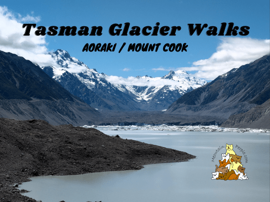
At about 22 km long, the mighty Tasman Glacier (Haupapa) is New Zealand’s longest glacier. However, as glaciers around the world are shrinking, Tasman Glacier is also receding rapidly, at a rate of over 100 meters a year. Tasman Lake, on the other hand, is a relatively ‘new’ lake formed in 1974. Since then, the lake has been growing steadily.
Both the Tasman Glacier View Track and the Tasman Lake and River Track offer you the scenic views of Tasman Glacier and Tasman Lake. The latter takes you lower and closer to the lake.
Blue Lakes & Tasman Glacier View Track
1.19pm: Both Tasman Glacier Walks start at the same trailhead from Tasman Glacier Car Park.
(+14)1.33pm: I first took the Tasman Glacier View Track, where you’ll see a side track to the Blue Lakes.
(+4)1.37pm: I first came across a brownish stagnant-ish little lake.
The track was almost covered with the spiky plants (not sure if they were the native Matagouri or the invasive gorse). It got worse as I proceeded further (lots of ‘ouch!’ sound effects as I carefully brushed through them).
(+8)1.45pm: Arrived at the (presumably) final Blue Lakes, which looked green.The incongruent name is due to when the lakes were named back in mid-1800s, they were blue. The lakes were blue as they were fed by turquoise glacier meltwater filtered through the moraine. It was a popular swimming spot in summer and skating rink in winter.
As the Tasman Glacier retreated, its meltwater no longer flows into these lakes. The lakes now get refilled by warmer rainwater, which supports green algae, turning Blue Lakes green. Once cold and barren, the Blue (or green) Lakes are now inhabited by native fish such as kōaro.
(+16)2.01pm: Back to the main trail to Tasman Glacier View Track. Staircases lead you up to the hilltop.
(+3)2.04pm: Near the top of the hill, look back.
(+2)2.06pm: Reached the viewpoint of Tasman Glacier. The glacier used to be very close to this viewpoint. The moraines lines show the glacier used to advance right in front of where we stand (and how high it was), before it started retreating and formed the lake.
See the blue ice wall? It’s a layer of glacier covered with rock sediments and debris. From afar, it looks like rocky ground but it’s in fact, chocolate covered ice block.
Tasman Lake And River Track
(+32)2.38pm: Walked back down to the junction and to the Tasman Lake & River Track. Approaching the end of the track, there is a tour operator taking passengers for a glacier boat tour.
(+7)2.45pm: Walking past the back of the tour operator, there’s a path climbing up over a hill for a closer look at the glacier and the alps.
(+47)3.02pm: Heading back on the track towards the exit, there’s also another split path that heads toward the headwater of Tasman River, which is the outlet for Tasman Lake.
The milky gray water is due to the large amount of ‘glacial flour’ (rocks grounded-up by the force of moving glaciers) in the meltwater.
(+38)3.40pm: Back to the car park. You might notice another trailhead nearby, which goes to Ball Hut Route (3-4 hours one way). It is also the start/end of the demanding multi-day Ball Pass Crossing (high level of experience with route-finding ability needed; unmarked track with steep alpine terrain on snow). Next, I’m heading to White Horse Hill Camping Ground for Hooker Valley Track 和 Mueller Hut Route.
帖子有帮到您吗?在您的登山故事和帖子中标记 @meowtainpeople 吧!
*地球队长经过* 记住,请保护我们的环境,请勿破坏大自然。不要留下任何垃圾,只带回照片和回忆(如果可以的话,还可以捡走一些垃圾)。请在指定的路径上行走,并尽量保持在中间行走,以使裸露的土壤不会进一步扩散/腐蚀。与大自然融为一体吧 *飞走了*
支持本网站的附属链接:
透明度万岁!:以上链接是会员链接,如果您用此链接购买或预订的话,我可以赚取佣金, 而你也不会被收取额外费用。 我只推荐我使用的产品和公司。您的支持可以帮助我保持网站的运行,让我继续用心分享🙂
想在您的网站进行相同的联属网络营销吗?用这个 AccessTrade 平台链接 获取 RM5 奖励。

