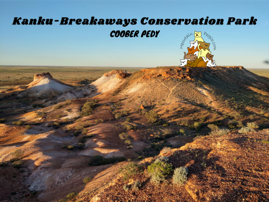

Kanku-Breakaways Conservation Park is an otherworldly desert, featuring spectacular coloured hills, flat topped mesas and gibber covered plains. It is located 25km north of Coober Pedy, and I recommend visiting this place when you are staying in the town.


You can drive there by yourself, but do check the current road conditions first. The dirt roads in Kanku-Breakaways Conservation Park are usually ok for normal 2WD cars during the dry season (mid/late autumn to winter months) after the roads have been graded. Rains and floods may hit occasionally, resulting in road closures, if not, turning the roads into 4WD-access-only.
Also, before you visit Kanku-Breakaways Conservation Park, you are required to pay for the conservation fee first. You can do so by paying at Coober Pedy Visitor Information Centre, or via online.
Best Time To Visit Kanku-Breakaways Conservation Park

Kanku-Breakaways Conservation Park is best visited in the evening, a couple hours before sunset. By doing so, you have enough time to explore the points of interest, before stopping at a scenic lookout point to witness the magnificent orange sunset changing the colors of the unique landscape. The optimal route to explore all of the park is to drive anti-clockwise through the park’s road, after you have stopped by at the Moon Plain (Moon Country, shown on map above).

If the road conditions are bad or if you don’t feel like driving, there are tour operators you can engage in Coober Pedy to take you for a tour to Kanku-Breakaways Conservation Park. I booked with Oasis Tours Coober Pedy for the Sunset Breakaways Tour. With a tour, the conservation fee is included in the package, so there’s no need to pay for your fee separately.
Coober Pedy Moon Plain
The Moon Plain is outside of Kanku-Breakaways Conservation Park, but it is a good short detour to see the moon-like terrain. Famous movies such as Mad Max Beyond Thunderdome (1985), Pitchblack (1998) and Red Planet (2000) have used this area as their filming location.
To reach the moon plain, drive over the cattle grid through the opening of the 5,614km dingo fence on Kempe Road. When you are at the grid crossing, a loud alarm will start blaring. Don’t worry, this is just one of the deterrents installed to deter wild animals from crossing the dingo fence opening.


The Moon Plain is a vast gibber-stone desert, known for its surreal, lunar-like landscape. However, there was a rare heavy rain that occurred a few weeks before my trip, so the supposedly barren desert has turned into a lively green land. According to the local guide, it is a very rare sight to see such greenery here!
Dingo Fence / Dog Fence: The World’s Longest Fence (5,614km)

After entering Kanku-Breakaways Conservation Park from Kempe Rd and driving along the park’s road, there is a section of the road that goes along the dingo fence and a parking space to stop to look at the fence.
The Dingo Fence (also called Dog Fence) was collectively built in the early 20s by settlers to create a single, long fence from Queensland, through New South Wales and South Australia, to the Great Australian Bight. Its purpose is to keep dingos out of the sheep grazing land. As a result, dingos are kept at bay. However, this manmade fence also significantly impacts the environment, dividing the country into two distinct ecological zones. You can read more about it here
Kanku-Breakaways Conservation Park


Sceneries along the way as we head towards Papa Kutjara (Two Dogs).


I think these are the outcrops named Papa Kutjara (Two Dogs), due to them somewhat looking like two dogs from certain angles.


A short hike to Lookout 1.


Insects in Kanku-Breakaways Conservation Park.


Desert plants springing to life after the last rainy days.


Scenic views from Lookout 1. Over 70 million years ago, this entire area was covered by an inland sea. And the ‘Breakways’ outcrops have been formed by two processes: First, sedimentary rocks were deposited over 70 million years ago. Then, 25 million years ago, an extremely durable sulcrete layer formed over these large sediments during a period of high temperatures and rapid groundwater evaporation.

A short shop at Queenie’s View lookout area with informational boards.

Here you might spot a number of holes by the side of the hills. According to the guide, these are dug by kangaroos/wallabies to avoid the hot sun, as there is not much trees or shades in the area.


Finally, we stopped at Antakirinja scenic lookout point for the sunset view.
Have this guide helped you? Tag @meowtainpeople in your hiking stories & posts!

*Captain Planet passing by* Remember, please take care of our environment, and please don’t destroy the Nature. Leave no trash behind and take back only photos and memories (and also some trash if you can). Walk on the designated path and stay in the middle as much as you can, so that the exposed soil doesn’t spread/corrode further. BE ONE WITH NATURE *flies away*
Affiliate Links to support this site:
Yay for transparency!: The links above are affiliate links, and at no additional cost to you, I earn a commission if you make a booking/purchase after clicking the links. I recommend only products and companies I use. Your support helps me keep the site going 🙂
Want to do the same affiliate marketing with your site? Use this AccessTrade platform link to receive RM5 reward.