
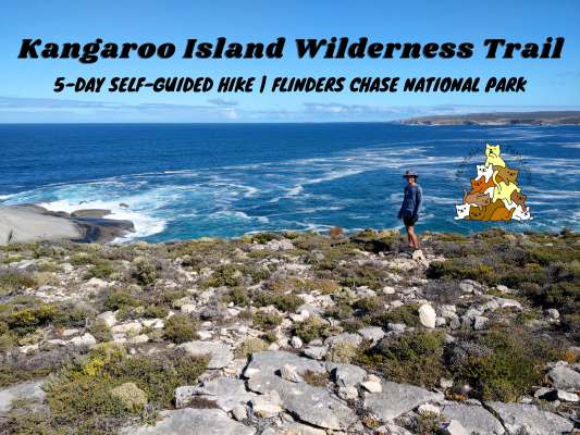
Kangaroo Island Wilderness Trail (KIWT) is the best nature experience you could get from the wonderful Kangaroo Island in South Australia. It is a 5-day hike that spans over 66km that provides unparalleled access to some of the most rugged, remote and spectacular coastlines in South Australia. Kangaroo Island Wilderness Trail can be done independently (self-guided) or with a tour guide.
There are four campsites throughout the five day hike for independent hikers, and each has a separated section for tour groups. The four campsites cannot be skipped or stayed for an extra night (at least for self-guided hikers), so the 5-day itinerary is fixed. Some tour groups do not stay in the campsites, but get transported in and out the starting/ending points of each day back to their accommodation. You can book your self-guided KIWT hike 这里, or find a guided tour operator 这里.
How To Get To Kangaroo Island - Ferry


Located 13km off the South Australian coast, the main transportation to Kangaroo Island is via ferry operated by Sealink. It is a 45-minute ride from Cape Jervis (mainland) to Penneshaw (Kangaroo Island). You can bring your vehicle along, or hire one on the island.


Beautiful sunset from the ferry on the way back to the mainland.
Kangaroo Island Accommodation - Seafront Holiday Park Kangaroo Island


While on Kangaroo Island, I highly recommend staying at the glamping tent in Seafront Holiday Park Kangaroo Island. Close to the ferry landing, it is a caravan park with glamping sites and luxury hotels/cabins catered for all styles and budgets. Their shared bathrooms are sparkling clean and amazing!
Kangaroo Island Wilderness Trail - Day 1: Rocky River Section (Flinders Chase Visitor Centre to Snake Lagoon) 18km


10.28am: After the induction by the national park staff at Flinders Chase Visitor Centre (where you collect the complimentary trail map, a nice informational book about Kangaroo Island’s nature and history, arrange the free shuttle bus from the end point back to this start point, and to book the complimentary Kelly Hill Caves tour), I started my Kangaroo Island Wilderness Trail journey.
This hike was done in mid-early spring.


(+8)10.36am: The hike starts easy with gentle gradients through some interesting vegetation.


(+15)10.51am: A short side trip to an unnamed lagoon.

(+22)11.13am
Platypus Waterholes

(+63)12.16pm: The trail enters the Platypus Waterholes area. Walk counterclockwise to discover the platypus viewing platforms, or turn left to skip this 25-minute side trip (why tho?).

Along the KIWT journey, you’ll spot many of these burned plants and seeds (e.g. banksia). Bushfires are a natural phenomena in Australia and many plants have evolved to adapt to these environments. Some plants actually require fire to help them germinate or disperse seeds.


(+11)12.27pm: One of the larger platypus waterholes (some others were dried up). I had my lunch break while quietly keeping a look out for any noise or movement from the shy and elusive platypus. These Australian native platypus were introduced to Flinders Chase National Park in the early 1900s to protect them from possible extinction on the mainland.
Apart from a goanna (monitor lizard) searching for food along the edges of the waterhole, there was no sign of the platypus. Scientists believe that during summer when the rivers stop flowing and food becomes scarce, platypus go into torpor (sleep) inside their burrows for months, only to emerge when conditions improve. I guess it was still too dry for them to be active during this mid-early spring period. During active seasons, watch out for bubbles on the water surface and you might get to spot a platypus coming up for air.

1.11pm: Continuing the journey, I passed by this bridge where some platypus burrows can be spotted along the banks.

A goanna by the trail.


(+57)2.08pm: The trail briefly goes out onto a national park road to cross a small bridge, before reentering the trail on the other side (well-marked).

(+27)2.35pm: At Pardalote Lookout you can see the winding Rocky River and the vegetated inland dunes beyond.

(+9)2.44pm

(+24)3.08pm

(+8)3.16pm: Rocky River catchment

Unique rock formations around the back.

Spent some time sitting here, trying my luck to spot a platypus. None spotted but it was a nice place to sit quietly on this cool sunny day.

3.39pm: Continue on, there is an option to take the main ‘dry trail’, or alternative ‘wet trail’ during wet seasons. In wet weather the trail may be soft and muddy, making it susceptible to erosion. Since it was dry, I took the dry trail.

(+1)3.40pm: In winter, the Rocky River cascades will be flowing but not during this time.

(+3)3.43pm

Another goanna on the trail.

(+26)4.09pm: I arrived at the first camp.
Cup Gum Campground - KIWT


Cup Gum Campground is the campground for the first night. It has a relaxing setting and you get to select either raised wooden platforms, or compacted earth for your campsite. The raised wooden platforms are the best choice as it is smooth and leveled, and you don’t get dirt onto your tent. The compacted earth campsites were hard with many little sharp rocks.


Just when I was putting down my backpack on the platform of my choice, I heard rustling and saw an echidna roaming about the campground!
Kangaroo Island is home to two of the world’s three remaining species of monotreme (egg-laying mammals) – the platypus and the echidnas. In late spring or winter, you might even get lucky and find an ‘echidnas train’, in which a line of male echidnas follow a female echidna in order to compete and mate.

Tent set up.

Common area with shelter and sink. The tap is powered for pressurized water output. The rainwater collection tanks are big and water was abundant for drinking and simple washing. All the campgrounds on KIWT have pretty much the same facilities setup, but different campsites setup/placement.


The hybrid compost toilets are great.

More echidnas spotted as I wandered around the campground.

The night was quiet and peaceful, apart from the random sounds of heavy footsteps of the kangaroos hopping around the campground.
Kangaroo Island Wilderness Trail - Day 2: Maupertius Section (Snake Lagoon to Cape du Couedic) 14km

9.07am: Starting the second day of my KIWT journey.

(+9)9.16am

(+6)9.22am: The day starts with hiking along the Rocky River towards the river mouth at the coast.

(+1)9.23am: The bridge to cross the river (not flowing during my hike).

View of Rocky River (pooled) from the bridge.

(+3)9.26am: Continue walking towards the river mouth after crossing the bridge.
Side Trip: Rocky River Mouth (Snake Lagoon Hike)

(+1)9.27am: The short Snake Lagoon Hike starts near Cup Gum Campground and shares the trail towards the Rocky River mouth. It separates from KIWT here to reach the river mouth, which is an optional side trip from KIWT.

(+3)9.30am: The trail heading towards the river mouth.

(+5)9.35am

(+5)9.40am: The ocean and beach come into view.

(+4)9.44am: Onto the sandy beach.

Some kind of cave on the adjacent hill.

At the end of the beach. Can you see the ‘snake head’?

(+20)10.04am: Back to the main track turnoff to KIWT. Now you’ll be walking along the adjacent hill above the river mouth.

(+7)10.11am

(+3)10.14am

(+4)10.18am: The view of the Snake Lagoon hike’s beach below.


(+4)10.22am: Once you make your way up the hill, you’ll be rewarded with the first breathtaking view of the mighty Southern Ocean!

(+7)10.29am: The trail now heads southeast along the island’s wild and rugged coastline. From here I hiked towards the beach of Maupertuis Bay.

(+6)10.35am

(+4)10.39am: Unique coastal plants.

(+1)10.40am: Upon reaching Maupertuis Bay you’ll head down from the clifftop onto the beach below. There are two choices: Walk the low tide trail across the sandy beach, or the high tide trail when the tide is in and there is no beach visible, or when the waves and swells are high.

(+2)10.42am: Since it was low tide, I took the more direct low tide trail on the beach. The high tide trail through the dunes can be hard to walk as the sand is high and soft.


(+20)11.02am: There is no trail marker on the beach route but you’ll just need to walk to the other end of the beach. You will know when to exit the beach as you find the trail marker.

(+2)11.04am: Eventually the trail winds its way back up the rocky clifftop and offers a spectacular view of how far you have travelled.

(+6)11.10am: Here at the edge of the world there is nothing but the deep blue sea between you and Antarctica.


(+9)11.19am: Had my early lunch break here as I soaked in the sound of the thundering waves that crashed against the cliffs.

11.49am: Continued on the trail.

(+3)11.52am: There is a bench here for fantastic views.


(+12)12.04pm

(+9)12.13pm

(+19)12.32pm

(+12)12.44pm: Looking back to see how far I have walked.

(+15)12.59pm: Loch Sloy cairn. Out in the water here is a shipwreck of Loch Sloy (1899).

12.59pm: Cape du Couedic Lighthouse visible over the distance, which I will visit later in the day after setting up my tent at the campsite.

(+76)2.25pm


(+5)2.30pm: The trail then turns inland towards the campground.
Hakea Campground - KIWT


(+13)2.43pm: Arrived at Hakea Campground, campsite for the second night.
Side Trips: Weirs Cove Ruin, Admirals Arch, Cape du Couedic Lighthouse - Flinders Chase National Park

3.26pm: After setting up my tent, I brought along my water and torchlight and began the side trip to Weirs Cove, Admirals Arch and the lighthouse.

(+3)3.29pm: A loop trail is available and I did it clockwise by exiting the campground towards the next day’s trail. There is a road here to cross over to the trail on the other side. This road is used by visitors to drive to some points of interest around the national park, such as the Admirals Arch and Remarkable Rocks.

(+2)3.31pm: Follow the sign to KIWT Weirs Cove spur trail.

(+7)3.38pm: The second road to cross. This road is heading towards the Remarkable Rocks.


(+22)4pm

(+2)4.02pm: Weirs Cove historical ruin.

(+2)4.04pm: Weirs Cove lookout point.


(+2)4.06pm: There is a gravel road that connects to the main road to Admirals Arch, but I saw this trail marker that continues the Weirs Cove Hike towards the arch, so I took this trail.

(+7)4.13pm: The trail has clear tracks but a little confusing with many split paths towards the general direction.


(+10)4.23pm: The path I took led me along the edge of the cliffs.

(+13)4.36pm: I could see the Admirals Arch walkway from here.


Seals spotted resting on the rocky headland below, while rough waves constantly crashed onto the rocks.

(+3)4.39pm: Onto the wheelchair-friendly walkway to Admirals Arch.


There’s a large colony of fur seals around the rugged rocky headlands around Admirals Arch. Some little seals were swimming in the calm water pooled on the rock above sea level.

(+8)4.47pm: At the end of the walkway is the viewing platform of the Admirals Arch.

Admirals Arch is a natural rock bridge with stunning stalactites, sculpted by thousands of years of erosion.

5pm: Taking the main road from Admirals Arch car park to the lighthouse.

(+8)5.08pm: Cape du Couedic Lighthouse.

(+7)5.15pm: Continue along the main road to South Swer Track turn-off.


South Swer Track is an authorized-vehicle-only road, but walkers are allowed to use it. The gate is closed for vehicle access, but open for walkers access. This track is also known as Cape du Couedic spur trail.

(+22)5.37pm: Follow the track until the KIWT campsite trail marker. This is the same turn-off I arrived before the campground.

A rainbow appeared as I headed back to the campground.

At night at Hakea Campground, the air was still and the temperature was not too cold.
Kangaroo Island Wilderness Trail - Day 3: Sanderson Section (Cape du Couedic to Sanderson Bay) 13km

9.07am: It was a warm sunny morning when I started my third day of KIWT. The trail enters dense coastal mallee trees forest.

(+118)11.05am: Side trip junction to Remarkable Rocks.
Remarkable Rocks - Flinders Chase National Park

(+12)11.17am: Perched 75 meters above the crashing sea, the Remarkable Rocks is an abstract collection of granite boulders shaped by the corrosive forces of wind, sea spray and rain.


Hundreds of millions of years of erosion have seen the rocks rise from more than 10km below ground, fracture into sheets and weather into the shapes we see today. Orange lichen that covers some of the rock surfaces add to the beauty of the landmark.
This slow growing hybrid organism consists of an algae (providing food through photosynthesis) and a fungus (providing stability and water). This pairing makes lichens the only living thing able to survive on bare rocks.

This is probably the most iconic / recognizable shape among the Remarkable Rocks.

Does it look like a bird (eagle?) looking at an egg or a stone?

This angle reminds me of an elephant seal’s droopy nose.

11.46am: Back to Kangaroo Island Wilderness Trail leaving the crowds.

(+2)11.48am: The trail hugs the coastline and offers cinematic views that vehicle-based or day visitors would have missed out on.

(+4)11.52am


(+20)12.13pm: Look out down below for long-nosed fur seals and Australian sea lions that breed along this stretch of the coast.

(+16)12.29pm


(+8)12.37pm: A bench overlooking the magnificent coast and the colony of seals and sea lions below.

(+10)12.47pm: The trail heads inland as you approach the next campground.

What? A random dismembered kangaroo paw on the ground??? Maybe it’s the Aussie version of The Monkey’s Paw…
Banksia Campground - KIWT


(+42)1.29pm: Arrived at Banksia Campground (night three).

Can you guess the animal by these footprints and trail? I reckon that’s an echidna’s paw prints and the line drawn by its tail.

Set up my tent on a wooden platform. Some campgrounds have the raised wooden platforms only at the guided group’s side, and only the hard and sharp compacted earth pads for the self-guided group. However, since there was no guided group using the campground during my 5-day hike, I took the guided group’s platform when there was none at the self-guided’s side.
Side Trip: Banksia Campground to Sanderson Bay Beach

The secluded beach of Sanderson Bay is close to the campground, just a 7-10 minutes walk. It is well signposted and you will meet the turn-off junction on the way before reaching the campground.

I wanted to take a bath at the ocean but the waves were quite rough, so I aborted the plan of getting into the water.
Kangaroo Island Wilderness Trail - Day 4: Grassdale Section (Sanderson Bay to Grassdale) 13.5km

10.16am: Day four of KIWT offers another galore of coastal scenery.

(+13)10.29am

Looking back from time to time you’ll continue to be rewarded with the distant views of the Remarkable Rocks.

(+32)11.01am

(+6)11.07am: Approaching Cape Younghusband


Seals / sealions below the dynamic cliffs.

(+31)11.38am: A bench with breathtaking views.

(+7)11.45am

(+8)11.53am: The trail leaves the last section of coastline and goes inland for the rest of the trip.

A wallaby hiding in the bush.

(+61)12.54pm: Crossing Hanson Bay Road (private property – Hansen Bay Cabin access road).

(+16)1.10pm

(+2)1.12pm: At this sand dunes section it was a little ambiguous as there wasn’t any clear trail or marker.

(+1)1.13pm: Although there’s no marker pointing to the left, I figured out the trail goes up the small hill of sand dune to the left.

(+4)1.17pm: Looking back from the top of the sand dune hill.

(+23)1.40pm: One of the highlights of traveling on the fourth day of KIWT is crossing the South West River. This river crossing involves getting onto the boat (wear the life jackets provided in the trunk) and using the rope attached to pull yourself across to the opposite bank.
Side Trip: Hanson Bay Hike (Awesome Swimming Beach!)


1.46pm: Right after crossing the river is a junction to Hanson Bay side trip.

A goanna by the trail.

(+6)1.52pm: After walking up a headland, you’ll see the spectacular Hanson Bay beach on the right side.


On the left side is also a beach, but the waves were swelling and looked unsafe to swim. Many kangaroo footprints spotted at the beach.

Hanson Bay’s beach on the right side, however, was calm with gentle gradient in the water.

Astonished by the sparkling water and influenced by the fact that I haven’t had a shower since the start of this journey, I had the most wonderful swim in the cold refreshing water on this nice warm day!

2.59pm: Back to the main trail.

A pair of swans cruising along the river.

(+14)3.13pm: The trail passes through some open areas along the winding river.


(+9)3.22pm: Thorny plants along the sides of the trail.

One of the many times I spotted an echidna along the way. Tips to spot echidnas: Echidnas usually curl up and stay still when they hear someone approaching, making it difficult to spot them among the bush with same color tones and spiky shapes. However, they are rather quick to resume doing their thing when the noise or movement stops. When echidnas move, their spikes make quite a noise brushing against the bush. I often find an echidna simply by stopping on the trail for a few seconds, and listen for any rustle after that.

(+7)3.29pm: A rare sight of the first big tree after hiking through low coastal vegetation most of the time.

(+8)3.37pm: At the trail entering Tea Tree Campground, you could see the new log steps (for when the ground is flooded/muddy), and the old ones that went through bushfires (the biggest one happened in 2020). Throughout the journey I also noticed the signs of Kangaroo Island recovering from the massive fire many years ago.
Tea Tree Campground


(+5)3.42pm: Arrived at Tea Tree Campground, the final campsite of Kangaroo Island Wilderness Trail.

Order pizza delivery at the campsite? Well, too bad it was already past 3pm.

The campground is situated on both sides of the river, with a bridge crossing over to the camping pads/platforms. You might be able to spot some wildlife foraging by the banks. Also, there are many kangaroos roaming around the area from dusk to dawn.

My campsite for the final night.
Side Trip: Grassdale Cottage


At the back of the campground pass the toilets is a short walk to the historic Grassdale property.

The open area at Grassdale is a good place to watch grazing kangaroos, especially during sunsets. At the opposite end of the land is the old cottage that housed the Edwards family who were pioneers in the early settlement of the western end of Kangaroo Island.

A number of kangaroos have already started to hang out around the area.

With the night well-lit by the full moon, I quietly watch the kangaroos before heading back to bed.
Kangaroo Island Wilderness Trail - Day 5: Kelly Hill Section (Grassdale to Kelly Hill Caves) 7.5km


7.31am: On the last day of KIWT, I left the campsite earlier in order to make it to the trail exit in time for the complimentary Kerry Hill Caves tour I booked at 10am. There is another later option (I think it was 3pm) if you prefer to take your time on the trail.

(+30)8.01am: The trail passes by Wilderness Lagoon and Glassdale Lagoon.

(+21)8.22am: The lagoons are listed as Wetlands of National Significance. The Wilderness Lagoon provides a rare year-round water source for wildlife. Both lagoons offer breeding and foraging habitat for a diversity of woodland and wading birds.
Above the banks at the eastern side of the lagoons are good spots for birdwatchers to spot birds in the morning. The croaking of four out of six species of frogs found on Kangaroo Island could be heard here.

(+16)8.38am: Hiking through beautiful sugar gum and old growth banksia woodlands.

(+41)9.19am: Finally, I arrived at the trail end of Kangaroo Island Wilderness Trail. There is one last activity to do before I officially complete my KIWT journey.
Kangaroo Island Wilderness Trail Complimentary Guided Tour: Kelly Hill Caves
The Kelly Hill Caves guided tour starts at the park office close to the exit of Kangaroo Island Wilderness Trail. You’ll explore the ancient labyrinths that weave through a timeless under-world.


With ancient caves full of magnificent yet fragile stalagmites, stalactites, helictites and towering columns, they transport you to a whole new different world of the underground.
The large system of Kelly Hill Caves also contain a rich fossil record of megafauna, including a giant python and giant echidna that have not been found elsewhere. Fossils of the extinct mega kangaroos, giant marsupials, and massive meat-eating mammals have been found on Kangaroo Island

Not long after the tour at Kelly Hill Caves, I met up with the only other group of three lovely hikers (apart from a guided tour group, who did not stay at the campground) I met on the journey, who we shared the campground and trails for the past 5 days.
They told me they saw a koala sleeping on a tree right next to our last campground’s shelter. We waited for the scheduled shuttle bus to take us back to the starting point at the national park visitor centre, where we parked our car.

Ah… Good hot food after five days of eating cold meals. Cape Jervis Tavern is a wonderful pub with busy but homely local vibes, not far from the ferry landing on the mainland. They also offer good accommodation with reasonable price (I stayed there for one night for $90).
帖子有帮到您吗?在您的登山故事和帖子中标记 @meowtainpeople 吧!

*地球队长经过* 记住,请保护我们的环境,请勿破坏大自然。不要留下任何垃圾,只带回照片和回忆(如果可以的话,还可以捡走一些垃圾)。请在指定的路径上行走,并尽量保持在中间行走,以使裸露的土壤不会进一步扩散/腐蚀。与大自然融为一体吧 *飞走了*
支持本网站的附属链接:
透明度万岁!:以上链接是会员链接,如果您用此链接购买或预订的话,我可以赚取佣金, 而你也不会被收取额外费用。 我只推荐我使用的产品和公司。您的支持可以帮助我保持网站的运行,让我继续用心分享🙂
想在您的网站进行相同的联属网络营销吗?用这个 AccessTrade 平台链接 获取 RM5 奖励。