
Bukit Batu Chondong hike was a short but challenging one. It takes about 30 minutes to reach the top, but the path was steep all the way up. Some parts also require a slightly more technical climbing method.
But don’t be too sad, there are still 5 waterfalls nearby for you to explore!
Quick Walkthrough:
Ampang River Waterfalls:
Lata Sham
Lata Gitar
Detailed Walkthrough:
Bukit Batu Chondong
Entrance / Trailhead
The trailhead is located near ATV Adventure Park. To reach there, you have to drive past Zoo Negara. Driving through a stretch of narrow tarmac road, you may sometimes need to give way to the opposite traffic. Once you reach the trailhead, drive further up where there is space you could park by the roadside (but not up to the ATV Park entrance). You may be allowed to park at the ATV Park customer’s parking spot with a RM3 fee (I’m not sure, I went there early, the park wasn’t open yet).

The trailhead is by the chicken coop.

Steep starting point.

It was raining the night before, the steep path was slippery.

Lots of bamboo
Cross Road to Bukit Batu Chondong / Batu Asah Waterfall

When the path splits into three, take the middle one to Bukit Batu Chondong. ATV riders would come from the right and head to the left. Following the left path will take you to Batu Asah Waterfall, which we will cover later in this post.

Be aware of some spiky plants that might be handing overhead or at the side.

There was a split path. I tried using the left path but the soil was loose and very slippery. I decided to backstep and take the right.

I took the path to the right, it seemed easier.

Nope, still difficult… Very steep and slippery. You need to find proper grips using rocks, tree roots, and a rope hanging there.
Bukit Batu Chondong Peaks

After passing the previous steep climb, there were a few peaks. The highest one plus a few more are on the left. There is one on the right which was easy to reach within a minute. Above images were the views from the rocks on the right.

On the left are the paths to the higher peaks.

To the peaks, you have to get to the top of this rock. Fear not, as there are three ways to choose from: Hard, Moderate & Easy

Hard – A vertical climb through cracks with a hanging belt to assist you.

Moderate – An almost vertical climb using ropes with the tree attached by the rock.

Easy – A path to walk around the rock and eventually reaches the top.

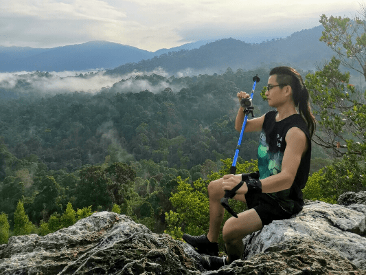
At the top, walk and climb to the other one at the Northwest direction to the peak with this Bukit Batu Chondong signboard.

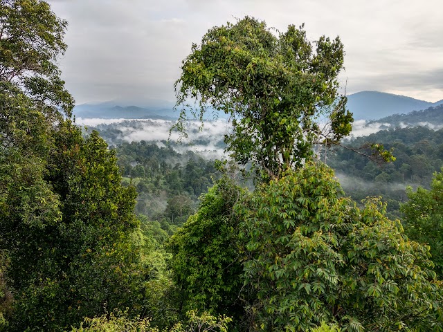
Beautiful cloudy mountainous view

You could also see the officially closed and forbidden Bukit Tabur. (Note: It is ILLEGAL to hike Bukit Tabur without permits from the Selangor Forestry Department)


Camera set-up. Don’t need a selfie stick when you could use a hiking pole ;P

A few more peaks are accessible at the back and at the North. Please proceed with caution.
Batu Asah Waterfall

Heading back down from Bukit Batu Chondong to the previous cross junction, we took the path to the left (right side when coming down from Bukit Batu Chondong).

We walked the muddy ATV tracks.

After ten minutes, the track goes down and joins a bigger track. Make sure you remember this part when you return using the same path.

We encountered a scorpion! Always be aware of your surroundings. My friend stepped right by the side of the scorpion without noticing it.
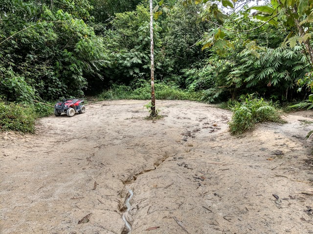
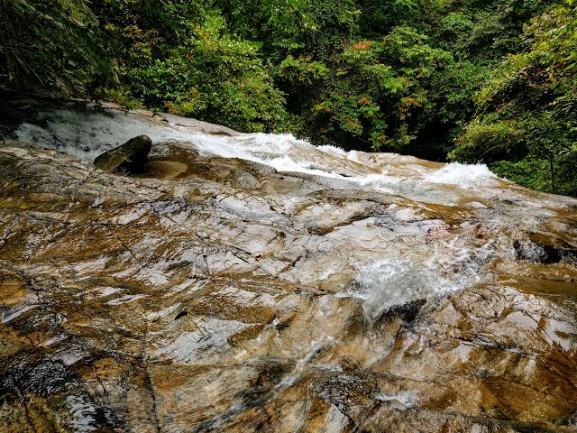
Walking the ATV track for 20 minutes, we reached this wide area. The waterfall is on the right. You will know where the waterfall is by the sound.

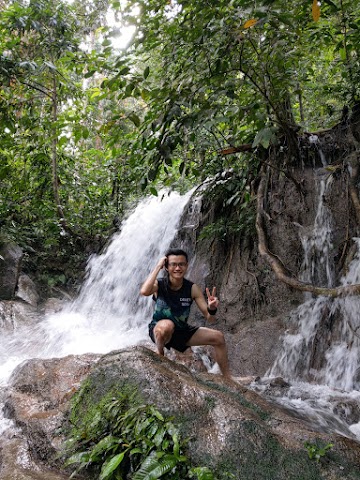
Cool and refreshing Batu Asah Waterfall, to calm down the nerves after the Bukit Batu Chondong hike and scorpion encounter.

Ampang River Waterfalls Trailhead

After we are done with the first waterfall, it’s time to head back out from Bukit Batu Chondong trailhead to the tarmac road. Walk pass ATV Adventure Park and all the way to almost the end of the road, before reaching the gate of a private school.

It was a long stretch of ATV tracks, muddy and slippery when wet. Along the way, there were many split paths but they will all join back together at certain points toward Kubang Gajah Waterfall (except: see below).

At a wide area with three junctions, take the right side to Kubang Gajah Waterfall). I heard that one can get to the other waterfalls from Kubang Gajah Waterfall (I will explain later).

You can take any of the two junctions on the right, one for ATV, and one for biking/walking. The one for bike or walking was easier as it was less muddy or slippery.
Jeram Kubang Gajah (a.k.a. Sofea Jane Waterfall)

It took us around 50 minutes of casual walk to reach the first waterfall. This is the Jeram Kubang Gajah (Elephant Pit Waterfall), it is said that elephants were used for construction nearby and they would take a bath here. This place is also called Air Terjun Sofea Jane by the locals (Sofea Jane Waterfall), named after an actress who did a drama scene shooting here.


Despite multiple signboards of telling people not to litter, there was trash around the campsites. They are willing to bring their stuff here but not willing to bring it back. How far are we to fix the mindset of fellow Malaysians?

From the flat ground before the waterfall, you can walk up to this path on the left.
It will bring you to the top of the waterfall.

There were some parts where you could walk on top but don’t go too near the edge. Be careful not to slip.
Lata Pinang & Lata Sham via Jeram Kubang Gajah

From the top of Kubang Gajah waterfall, you could either walk along the river, or take this path to the upper stream.

At this manmade stair, there are two rivers from the upstream joining together.

If you follow the river to the left, it could take you to Lata Pinang. We tried but the path seemed to be inaccessible due to the tree branches covering the riverpath. If you take the right river upstream, you could reach a smaller waterfall, called Lata Sham. We tried that but were also blocked by the growing tree branches.
Lata Pinang
Slightly disappointed, we headed back but somehow decided to take this path, thinking it is an alternative path to the exit. The path here seemed less travelled but was quite wide and obvious. After walking for around 30 minutes, we realized we were actually walking toward Lata Pinang.


Lata Pinang
Lata Gitar (a.k.a Air Terjun Neelofa)

According to sources, you could reach another waterfall (Lata Gitar, also called Neelofa by the locals, named after another actress) by following a very steep path by the left side of Lata Pinang. I went up the steep and slippery path, passed by the upper level of Lata Pinang, and to the top. I climbed to a point with some fallen trees and the path seemed dangerous, I did not proceed. We headed back with 65% satisfaction, covering Bukit Batu Chondong, and 3 waterfalls out of 5.

I went back to my car and got a surprise. Another scorpion was hiding by the gap under my car door. Luckily I noticed and it did not sneak in!
Epilogue
The hike to Batu Bukit Chondong is quick yet tricky and could be hazardous. You would need to get a little technical on climbing, know where to hold and step. Beginners can still achieve this hike without much problem but it is recommended to have supervision from someone with some experience to hike along with you.
As for the waterfalls, I was very disappointed to see trash and BBQ leftovers left by the visitors and campers, especially at Kubang Gajah Waterfall. This would lead to serious health hazards, especially Hantavirus or Leptospirosis. The smell of garbage was lingering in some areas. Please keep the waterfalls clean.
P.S. I spotted a few leeches during the waterfall exploration.
Have this guide helped you? Tag @meowtainpeople in your hiking stories & posts!
Affiliate Links to support this site:
Yay for transparency!: The links above are affiliate links, and at no additional cost to you, I earn a commission if you make a booking/purchase after clicking the links. I recommend only products and companies I use. Your support helps me keep the site going 🙂
Want to do the same affiliate marketing with your site? Use this AccessTrade platform link to receive RM5 reward.

*Captain Planet passing by* Remember, please take care of our environment, and please don’t destroy the Nature. Leave no trash behind and take back only photos and memories (and also some trash if you can). Walk on the designated path and stay in the middle as much as you can, so that the exposed soil doesn’t spread/corrode further. BE ONE WITH NATURE *flies away*
antara Lata Pinang & Batu Asah, which is more easier to reach?
Hi Fauzi. Batu Asah Waterfall is easier to reach (~20 minutes) because you only have to follow the ATV track to the waterfall.
The path to Lata Pinang is a little longer (~30 minutes) from the split paths shown above, but the trail is more ‘natural’, not too difficult also, the trail is obvious and easy to walk on.
Do note that the trailhead of Batu Asah Waterfall is different from the other waterfalls, but share the same trailhead with Bukit Batu Chondong.
Enjoy!