
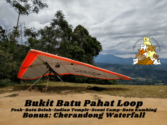
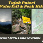
Bukit Batu Pahat Hiking Loop to Paragliding Peak, Batu Belah & Batu Kambing (3 Trailheads)
Bukit Batu Pahat is a popular hiking spot in Kuala Kubu Bharu that now requires a permit at RM5 (see how to apply for the permit here). At the height of 426 meters above sea level, it is not just a place for hikers, but also a takeoff point for paragliders.
During weekends, you would get to see many paragliders take off from the peak of Bukit Batu Pahat. Tired of just watching and wanna get into the action? Yes you can! The activity is open to the public and you can make your booking with KKB Paragliding Park (CloudBase) directly, or via Ticket2U.
Bukit Batu Pahat Hiking Loop | Part 1: Enter via Taman Tasik Milenium to Peak

Entering Bukit Batu Pahat trailhead via Taman Tasik Milenium is the most direct and convenient method, in terms of parking. There is plenty of space to park by the side of the road. (Be warned though, this path may be the most stamina intensive one. It is a steep 4×4 road that goes up all the way to the peak.) Just walk to almost the end of the road and you will find the trailhead, marked with a big paragliding signboard.
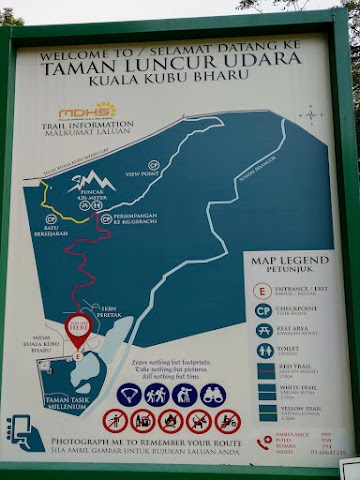
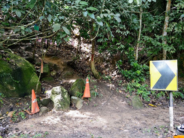
9.43am: A signboard at the trailhead entrance to show the trails. For this trip, I entered via Taman Tasik Milenuim (red trail), headed down from the peak to the Indian Temple (yellow trail), walked the highway to the Scouts’ Camp trailhead (white trail) back to the peak.

(+4)9.47am: The 4×4 trail starts out flat in the beginning.

(+4)9.51am: And soon, it starts to get steep going uphill. It will be steep all the way up to the peak at this point.

(+16)10.07am: The photo couldn’t show you the actual steepness of the road. One tip is not to rush, once you get exhausted halfway through rushing to the top, it is difficult to regain the stamina.

Occasionally, you need to give way to the 4×4 taking paragliders up to the takeoff point. Sometimes I found myself on a narrow path, so I had to run to a better spot to give way to the trucks when I heard their engines.
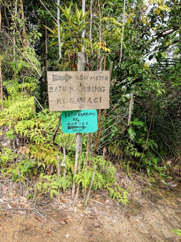
(+18)10.25am: When you see the junction to Batu Kambing. You know you are reaching the peak.

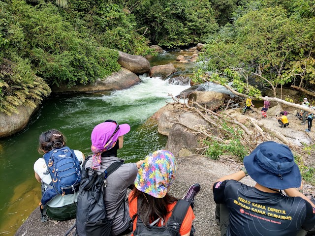
(+1)10.26am: Finally, after 40+ minutes of near-rushed pace, I reached the peak of Bukit Batu Pahat. Immediately I felt the cool breeze as soon as I saw the open ground.
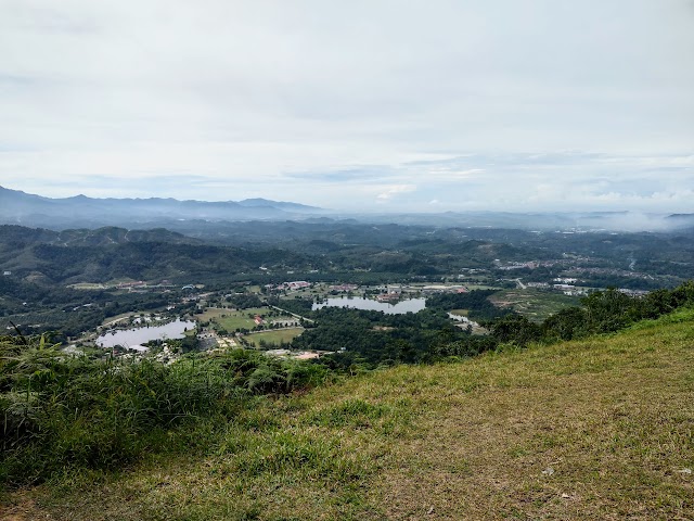
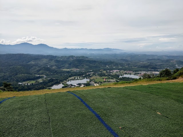
180° degree view of the mountains and Taman Tasik Milenium below.

You could also see Bukit Kutu on the left.

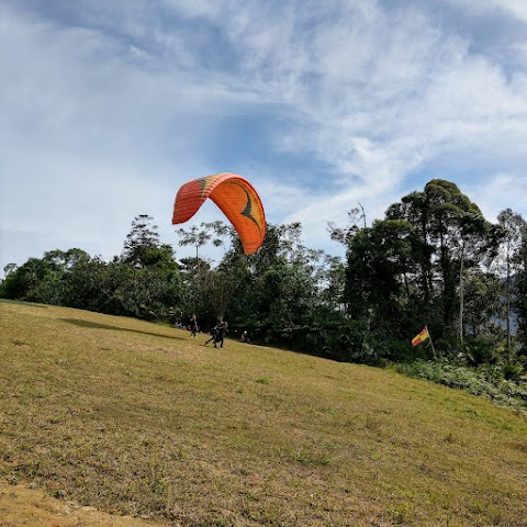
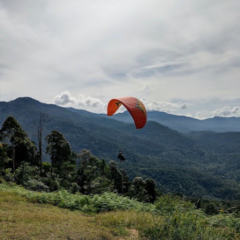
It was a weekend so there were many paragliders flying from morning till afternoon.
Paragliding takeoff point.
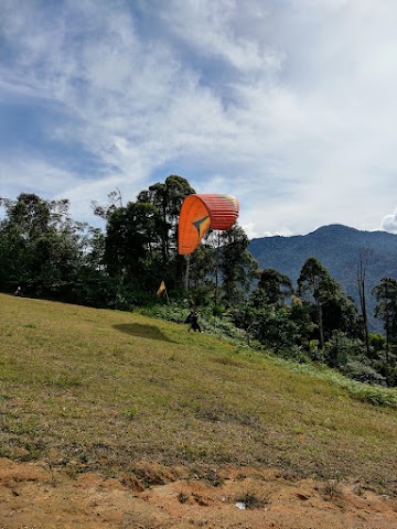
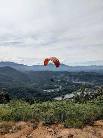
I enjoyed watching the paragliders running off the cliff and soaring high in the sky.

Some popular spots you usually see people taking photos here.

A swing without the swing.


Not to miss this platform with multiple paragliders in the background.

Also, I was lucky to be able to witness the takeoff of an air glider. Watch the footages of the various takeoffs in my video recordings below:
Bukit Batu Pahat Hiking Loop | Part 2: Peak to Batu Belah to Indian Temple

10.58am: The trail to Batu Belah and Indian Temple exit is at the other end of the peak, near the metal viewpoint platform.

It’s a little steep but not difficult to follow.
(+11)11.09am: Halfway down to the exit, is a junction to Batu Belah Viewpoint just a stone’s throw away.
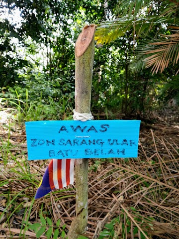
Cautious: Snakes’ nesting zone.

Batu Belah Viewpoint is a wide space with many huge rocks. Good for resting and has multiple spots for nice photos.

11.16am: Nice view of Kuala Kubu Bharu Town.


These photos were taken on another trip with Trailblazer Hiking Club Malaysia. We reached this viewpoint at 8.40am with a nice misty view.

Misty view of Kuala Kubu Bharu town below in the morning.


11.20am: Going back to the junction and continuing the trail down. The actual Batu Belah is further 20 meters down below. Walking down the trail around and under the viewpoint above.

If the viewpoint above is crowded, the view from the trail just below offers a good vantage point too. This was taken at 11.20am.

And this was taken at the same location but on a different day in the morning at 8.30am.
Batu Belah

(+2)11.22am: Just a couple minutes below the viewpoint is the Batu Belah site.

Batu Belah means ‘Splitted Rock’. As the name suggests, there is a huge split in the middle of this huge rock.

(+1)11.23am: There is a steeper sub trail at the other side of Batu Belah which you can take to reach the viewpoint above.

(+3)11.26am: Continuing down to the exit. Several dead trees marked with caution signs to warn hikers of the danger of falling trees.


Continue the steep downhill towards the exit near the Indian Temple.


(+16)11.42am: When you are near the bottom, there will be some paths with wet rocks as some water flows through here.

(+6)11.48am: Finally, I reached the exit point to the highway beside Sri Muneeswarar Veerapathra Kaaliamman Temple.
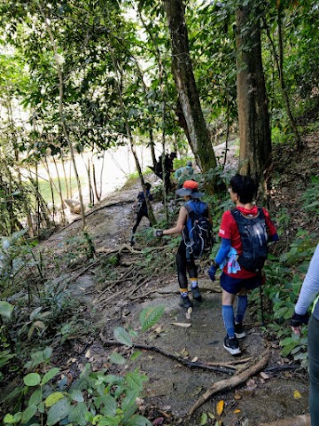
Bukit Batu Pahat Hiking Loop | Part 3: Scouts’ Camp Trailhead to Peak

(+3)11.51am: Next, I started the 20 minutes walk along the highway toward the Scouts’ Camp called Kem Pengakap Buloh Telor.

(+18) 12.09pm: Reaching the road to the Scouts’ Camp.

(+1)12.10pm: Here we go with the 4×4 uphill road again… Luckily it is a shorter one, unlike the one from Taman Tasik Milenium to the peak.

(+7)12.17pm: There was a construction doing electric cable works here, so the road was kinda eroded by the excavators.

(+19)12.26pm: As there were workers doing heavy construction work at that time, I waited around 10 minutes to get a safe opportunity to walk past the site. Do keep an eye for this trail at the top end of the construction road, near the transmission tower. There is a tree marked with red paint.

Due to the condition of the road, I had to carefully climb up the corroded path to enter the trailhead. Note: If you are using apps like ViewRanger, you would see a trail in their map from the Scouts’ Camp to the peak. Yet, walking this trail would show that you are not using that trail shown on the map.

(+1)12.27pm: Back into the shaded forest trail.

(+3)12.40pm: There was a part that got a little bushy.

(+2)12.42pm: A split path here, just follow the marker and take the one on the right.


(+3)12.45pm: Hike up some tree roots path and through some big rocks.
Batu Kambing

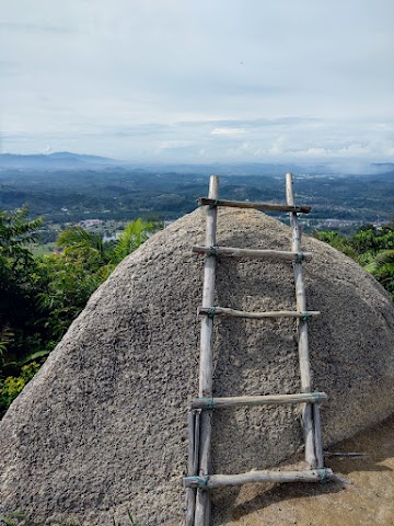
(+1)12.46pm: There was this rock with a ladder. The ladder looked kinda weak and I was alone, so I decided not to risk climbing it.

(+1)12.47pm: Behind me was this path which you should climb up to continue the trail.

(+1)12.48pm: After climbing up the path, I found out this was the spot called Batu Kambing (Goat’s Rock). I didn’t see anything that resembles a goat though.

Behind me is where the trail continues up to the peak.

(+2)12.50pm: Turn left at this trail.

(+3)12.53pm: Sign boards showing where you came from (Batu Kambing).

(+5)12.58pm: After that, the path opened up into an unshaded trail. I saw something running away that looked like a big rabbit or a small mouse deer.

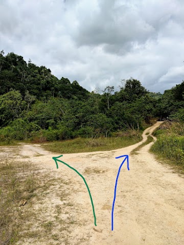
(+2)1.00pm: Back to the Batu Kambing junction. To the right is the peak and to the left is back to Taman Tasik Milenium.


After having my packed lunch at the peak, I spend around 30 minutes fast walking back down to the carpark.
Check out Jaszmyn’s video below of the Bukit Batu Pahat trip we joined, organized by Trailblazer Hiking Club Malaysia. This trip was done climbing up from the Indian Temple trailhead and back, so it is different from my write-up above:
Bonus: Cherandong Waterfall
During my first visit to Bukit Batu Pahat, I wanted to find the old trail that leads to the hidden waterfall. I got some info from someone working nearby, however, that part of the old trail requires a permit from the forestry. With that, I skipped searching for the hidden trail.
A few weeks later, Trailblazer Hiking Club Malaysia organized a weekday trip to Bukit Batu Pahat + Cherandong Waterfall, and I tagged along. After we hiked Bukit Batu Pahat, we drove to Cherandong Waterfall trailhead to start the next hike.

We parked at Cherandong Waterfall trailhead.

11.26am: Enter this trailhead to the Cherandong Waterfall.


The trail was a flat and wide plantation road.
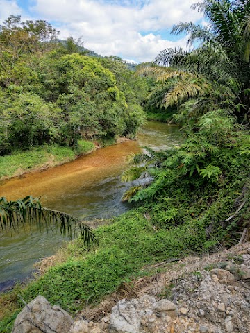
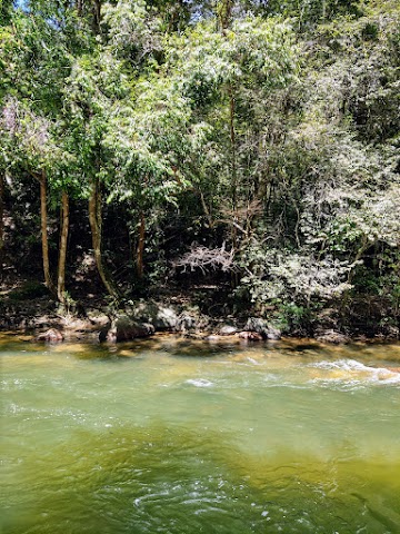
(+8)11.34am: After a while, we could see a few glimpses of the beautiful river along the way.

(+5)11.39am: There was a split path here, just follow the main trail and keep to the river’s side.

(+9)11.48am: A newly deforested part, not sure what it is for.

(+2)11.50am: There was a spot by the river with many makeshift huts for rent (Aban Mawang Camp).

(+3)11.53am: Continue walking towards Cherandong Waterfall. Most part of the trail is unshaded, so it is recommended to have some sort of sun protection.
At this junction, you can go straight to Cherandong Waterfall, or take a detour to the left for a nice river viewpoint.
Emerald Green Selangor River Viewpoint

Taking a detour to the left, this is the close-up view of the river at the bottom.

And this is the beautiful view of the emerald green Selangor river from the rock above.
With Trailblazer Hiking Club Malaysia team.
Cherandong Waterfall & Old Dam System

(+4)11.57am: Here is the entrance right before Cherandong Waterfall. Guarded and maintained by the local Temuan villagers, an entrance fee of RM2 is charged for individuals aged 15 and above. I heard rumors that the forestry might take over this forest area and a permit might be required in the future but I don’t see any verified statement yet.
(+10)12.07pm: We hiked the forest trail towards the river and waterfall.

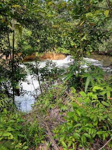
(+4)12.11pm: We first saw the river.

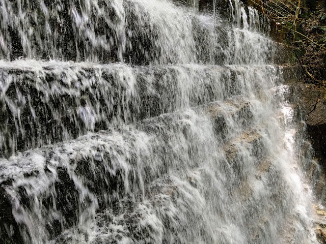
And then the special waterfall beside the main river!

Loads of water showering down from the mini cliff and flowing into the river.

With the awesome THCM gang. You can follow their YouTube pages at Jaszmyn & Active Above 40.
Right across the waterfall, opposite the river, is where the old trail to Bukit Batu Pahat is. Some hikers used to come down from Bukit Batu Pahat to this location. In that case, the waterfall will be at the opposite side of the river. It is not recommended to swim across the river as it is deep and has strong underwater currents.
Ampang Pecah Old Dam System


12.28pm: After the waterfall, we headed up toward the ‘manmade waterfall’ – a part of Ampang Pecah’s old dam system. We backtracked and took the trail junction just before the waterfall, and went uphill.
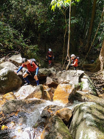

(+3)12.31pm: We walked over some rocks over Cherandong Waterfall’s upstream, to another waterfall. Then, we hiked up through the left side of this waterfall.

(+2)12.33pm: Some uphill after the waterfall.

(+3)12.36pm: Following the trail by the small river upstream, we saw a glimpse of the old dam system in the distance.

(+1)12.37pm: This is the Cherandong Old Dam. A short history class: There was this Kuala Kubu Dam, that collapsed in 1883, destroying the town of Kuala Kubu. Long story short, a new town was rebuilt in 1931 and it became the Kuala Kubu Bharu that we now know. (Bharu/Baru means new, so it is a new ‘Kuala Kubu’) The incident also explains the name of the area, Ampang Pecah (Pecah = Broken; Ampang = Empangan? = Dam?). Check out this Museum Volunteers site for more details of Kuala Kubu Bharu’s interesting history.
The stairs structure of the dam was part of British advanced technology of the time, to break and ‘soften’ the flow of water. The old dam was mainly used for mining activities.


You can explore further upstream above the old dam.

More waterfalls upstream.

Tried to explore further but it’s pure jungle beyond the rocks.
Check out Jaszmyn’s video of Cherandong Waterfall:

*Captain Planet passing by* Remember, please take care of our environment, and please don’t destroy the Nature. Leave no trash behind and take back only photos and memories (and also some trash if you can). Walk on the designated path and stay in the middle as much as you can, so that the exposed soil doesn’t spread/corrode further. BE ONE WITH NATURE *flies away*
Have this guide helped you? Tag @meowtainpeople in your hiking stories & posts!
Affiliate Links to support this site:
Yay for transparency!: The links above are affiliate links, and at no additional cost to you, I earn a commission if you make a booking/purchase after clicking the links. I recommend only products and companies I use. Your support helps me keep the site going 🙂
Want to do the same affiliate marketing with your site? Use this AccessTrade platform link to receive RM5 reward.
May I know Bukit Batu Pahat need permit now?
Hi Jiale. According to the government site (https://www.forestry.gov.my/my/perkhidmatan/info-perhutanan/hutan-lipur-hutan-taman-negeri#:~:text=Bukit%20Menggaru%20Mati-,Bukit%20Batu%20Pahat,-Bukit%20TakunAir), you need permit now. You may refer to https://meowtainpeople.com/hiking-permit-malaysia/ for the application methods.