
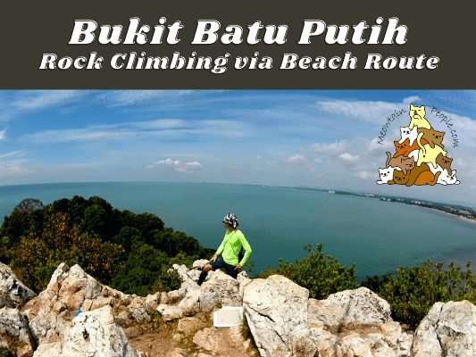
Bukit Batu Putih is a 200 million years old quartz ridge located in the historic Tanjung Tuan Recreational Forest.
Tanjung Tuan Forest Reserve

As a permanent forest reserve, a section of Tanjung Tuan Recreational Forest has also been gazetted as a Wildlife and Bird Sanctuary (60.70 hectares) since 1971. While the forest is connected to the land of Negeri Sembilan, the area is actually under the state of Malacca. Due to its proximity to Port Dickson, many refer to the popular hiking spot as Bukit Batu Putih Port Dickson.
Tanjung Tuan Recreation Forest is open to visitors daily from 7am to 6pm. Entrance fee to the forest reserve is RM1 and to be paid at the counter, no advance permit booking required.
One of the many attractions of Tanjung Tuan Forest is, of course, the hike to Bukit Batu Putih, which we will cover below. Other than that, there are more trails and beaches to explore around the forest reserve and I will guide you for the loop trails. Lastly, visitors who do not wish to hike the forest trails can walk up the tarmac road to Cape Rachado Lighthouse.
Bukit Batu Putih via Beach Route


12.20pm: All routes start from the main entrance of Tanjung Tuan Recreational Forest. The more straightforward route to Bukit Batu Putih is to walk all the way up via the tarmac road, and enter the forest trail on the right just before the lighthouse. The beach route is a more foresty, interesting path to climb to the peak of Bukit Batu Putih.


(+3)12.23pm: To use the beach route, just follow the tarmac road from the main entrance for a short distance. In about 3 minutes, you will find a trailhead to your right. Enter this trailhead to start the beach route.

This is a forest trail I prefer, rather than the hard tarmac road.

(+5)12.28pm: There is a split path midway, just keep to the right and go straight.


(+2)12.30pm: After 7 minutes, I exited the forest opening and reached the beach called Monkey Bay.

(+2)12.32pm: To the left is the direction you need to go towards Bukit Batu Putih.

(+3)12.35pm: First, walk to the left until the end, and you will find an opening to enter back into the forest trail.

Next, walk the trail along the side of the sea. Thanks to this trail, you do not have to walk on the rocky beach (yet) that may be submerged during high tide.

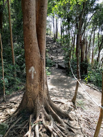
Follow the arrow on the tree and go straight.

(+4)12.39pm: Then, the trail will lead you back out to the beach.
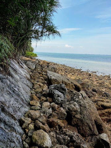
This time, instead of a sandy beach, it will be a rocky beach. Attention: This path will be submerged during the highest tide. The ocean current is known to be violent here at high tide, so it is not advisable to swim over it. Please check the timing of the tides before trying this route (see section below for tips).

(+5)12.44pm: So, walk along the rocks until you see the rock face leading up to the top. This is the starting point of Bukit Batu Putih rock climbing route from the beach.
Take note of the ocean tides (tips for Bukit Batu Putih Beach Route)

As the beach route may be uncrossable or risky during certain high tides, you need to check the ocean tides timetable to plan the timing of your trip. I search up Port Dickson tides and use this tide forecast site to check the timings.
As you can see, there are two lows and two highs every day. The ocean has the highest and lowest tides during full moon and new moon. To avoid getting caught in rising tides, it is important to know that the changes of tides are fastest during these moon phases. Knowing the timing is important especially if you are taking Tanjung Tuan Forest Reserve trail loop’s East side’s mangrove and rocky beach path.
Bukit Batu Putih Rock Climbing

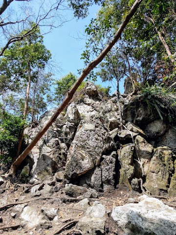
(+2)12.46pm: Here I start my rock climb activity up to the peak of Bukit Batu Putih. The rock face may look pretty intimidating as a whole, but fret not! You would feel more comfortable close up to the rock, as you will find many good spots to step or hold on to. Also, the path is not as steep as it looks, with many spots you can stand normally comfortably. As long as you have a pair of shoes with good grip, and proper sun protection, you are good to go!


(+7)12.53pm: Red arrows to guide you up to the top. Do check the cracks for scorpions and centipedes before putting your hands on them.

(+3)12.56pm: Remember to look back half way of your climb, to enjoy the nice ocean view.

(+8)1.04pm: Finally, reaching the peak of Bukit Batu Putih. It took less than 20 minutes of rock climbing.

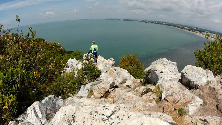
Nice 180 degree view of the sea and coast.

Have fun observing people’s reactions when you and your group climb up and emerge from the cliff below.
Bukit Batu Putih Peak to Lighthouse via Forest Trail
1.19pm: This is the mini rock climb path you will encounter if coming up from the lighthouse. I climbed down from here and headed to the lighthouse.

Wide and easy forest trail between Bukit Batu Putih and the lighthouse.


(+14)1.33pm: Exited the forest trail to the tarmac road near the lighthouse.

Unofficially dated to the Portuguese conquest of Malacca back in 1511, Cape Rachado Lighthouse has been reconstructed and upgraded several times throughout history. It is currently still a functioning lighthouse with a radar.

(+6)1.39pm: There isn’t a full view of the ocean from here, and the lighthouse is restricted for public access. Anyway, there is a trailhead at the back of the lighthouse to trek the nice forest trail and beautiful beaches. This is the path to continue the Tanjung Tuan Forest Trails Loop.
Tanjung Tuan Forest Trails Loop

This is the forest trail map of Tanjung Tuan Forest Reserve. I departed from the lighthouse (Rumah Api) and headed to Pulau Intan, followed by the beach near Pulau Mesjid. From the beach near Pulau Mesjid, I wanted to head North to the end, but halfway through the beach and mangrove route, I felt like the tide was rising, so I quickly turned back and took the West forest trail back to the tarmac road instead.

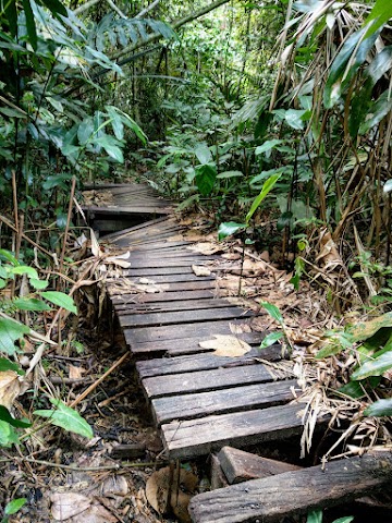
(+4)1.43pm: Along the way to Pulau Intan, there were a few observatory platforms but they were all in bad conditions. The wood planks looked like they were gonna break, you wouldn’t want to stand on them. Anyway, there wasn’t any good view from the platforms as the ocean view was blocked by the trees.

The forest trail from the lighthouse to Pulau Intan is more manmade. The stairways go down to the beach.


(+7)1.50pm: I followed the stairways down to the beach near Pulau Intan. The beach had only a few people at that time.

(+4)1.54pm: Re-entering the forest trailhead at the other short end of the beach.

(+1)1.55pm: Instantly, I exited the trail and out to another part of the beach.

(+1)1.56pm: Once again, re-entering the forest trailhead at yet another end of the beach.

(+8)2.04pm: Next, I reached this junction at the Southeastern corner of the forest. You can take the path on the left to continue the loop trail. But before that, you should go to the right to head toward the Southeastern tip of the land and see the view there.


(+4)2.08pm: Walk to the Southeastern end of the forest to see some ocean view.


(+2)2.10pm: You can choose to go down to the rocky beach if you want.

(+3)2.13pm: Headed back up and intended to go back to the junction, I found a shortcut on my right to continue the trail and took it.

(+1)2.14pm: Passing by a small opening where I can see the small Pulau Mesjid.


(+1)2.15pm: Intesting trail just beside the sea, the ground felt weirdly soft and hollow.


(+5)2.20pm: Soon, I reached the junction to continue the trail loop. The path on the left is where I was supposed to come from if I didn’t take the shortcut, so I took the path on the right.

(+2)2.22pm: Next, I reached this beach area with a concrete hut and a unique boulder.

(+2)2.24pm: Walking past the beach area where I met a small group of campers.

2.24pm: Here is the junction where you can choose to take the loop trail to the West (left) back to the tarmac road, or North (right) toward some mangrove and beach area.


First, I tried taking the trail to the right and walking the beach and mangrove route. But then, I wasn’t sure if there was an exit at the end of the path, and the tide seemed to be rising fast. As a result, I decided not to take the risk and turned back to the junction and took the path to the left.

(+19)2.43pm: Back to the previous junction and took the West trail towards the center of the forest and tarmac road.
(+1)2.44pm: This trail seemed to be less frequented as some parts of the trail were almost covered by thick bushes. There were a couple of broken wooden walkways that I had no choice but to cross cautiously.

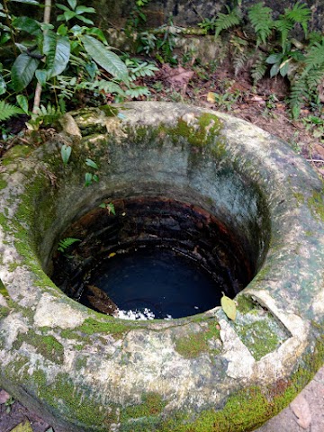
(+1)2.45pm: Passing by a concrete well along the trail.


(+3)2.48pm: After a while, the trail switched back to the stairway path leading upwards. There are a couple of mini huts along the way.

(+6)2.54pm: The trail joined back to the tarmac road and I walked back to the main entrance.
Have this guide helped you? Tag @meowtainpeople in your hiking stories & posts!
Affiliate Links to support this site:
Yay for transparency!: The links above are affiliate links, and at no additional cost to you, I earn a commission if you make a booking/purchase after clicking the links. I recommend only products and companies I use. Your support helps me keep the site going 🙂
Want to do the same affiliate marketing with your site? Use this AccessTrade platform link to receive RM5 reward.

*Captain Planet passing by* Remember, please take care of our environment, and please don’t destroy the Nature. Leave no trash behind and take back only photos and memories (and also some trash if you can). Walk on the designated path and stay in the middle as much as you can, so that the exposed soil doesn’t spread/corrode further. BE ONE WITH NATURE *flies away*
Yay for transparency!: Some of the links here are affiliate links, and at no additional cost to you, I earn a commission if you make a booking. I recommend only products and companies I use. Your support helps me keep the site going 🙂
U missed an attraction here which is the cave below Cape Rachardo (explorable only during low tide)
Oh yes, I only knew about that ‘mini cave’ after my trip there