
Bukit Serdang is a less popular hiking trail even for the residents nearby. Many people staying in Serdang do not actually know that there is a hiking spot in their area. Instead, most of them would travel further to Bukit Gasing or Puchong Wawasan Hill for a hike.
How to get to Bukit Serdang
Search Google Map for ‘Bukit Serdang Trailhead’ and follow its direction.

The map will lead you to enter this small road. Passing a factory on your right, take the first turning to the left.

After turning left, head to this road. Your vehicle can enter as long as it is lower than the pole. Otherwise, just park here.
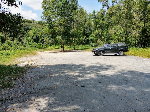
There is a large space to park your car inside.

Your hike starts here. Follow the trail to the mini bridge ahead.
Bukit Serdang Guides
While the hike in Bukit Serdang is relatively quick and easy (this could be the easiest hiking trail in Malaysia) depending on the paths you take, it is still highly possible to challenge yourself with a wide selection of trails to explore.
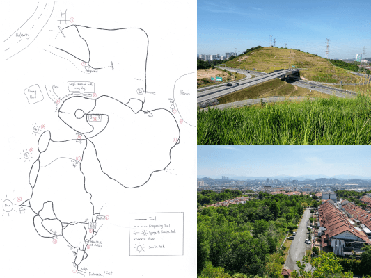
While the direct hike to the ‘peak’, or ‘Sunrise Peak’ as they call it, is pretty straightforward and takes around 15 minutes to reach, the other trails are quite confusing with many splitting junctions. To make this easy for you, I have spent a few hours mapping all the trails I could find. Below is the map I have drawn (click for full size map) to help you. Hope you enjoy the walks and explorations in Bukit Serdang!


1) Metal Bridge
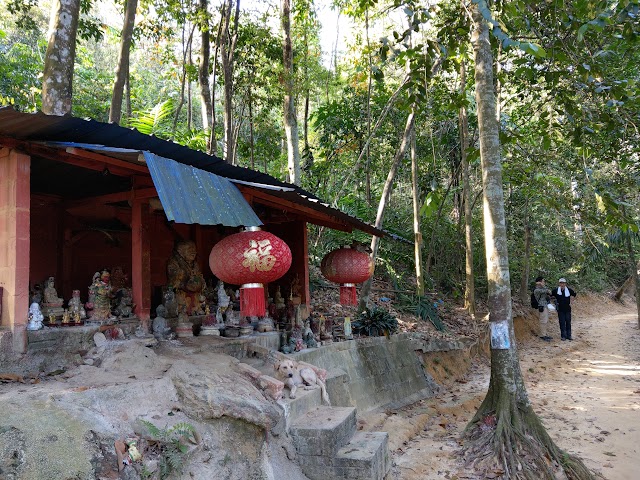
2) Shrine/Temple with Statues

3) ‘Dog Temple’, I call it that way because the dogs are always there

4) An area with lots of angpow (red packets) hanging at the time of my visit

5) Abandoned pail of rubber tree sapping

6) A pond (2021 update: Upgraded with huts and bridges by someone staying nearby)

7) Mini Hut

9) Damaged Hut


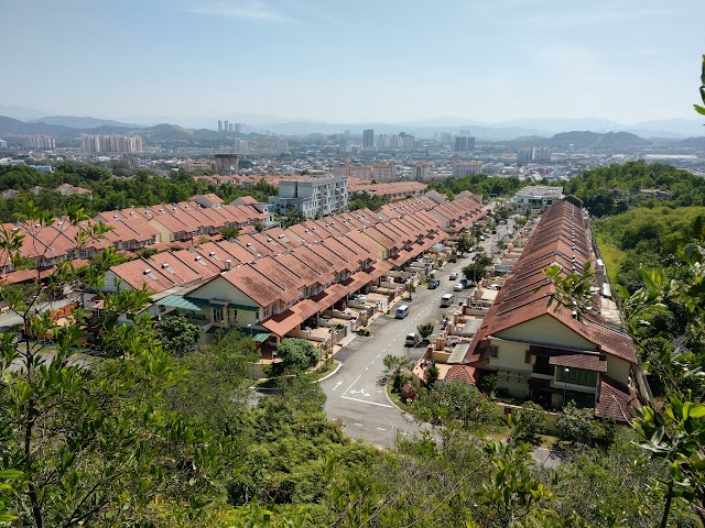
8) Telecommunication and Highway Lookout Point

10) Large compound with many dogs, looks like an animal shelter. Loud Buddhism chant music is played there.

11) Exit to Taman Universiti. I can see a few fishing ponds outside.


12) Resting stop with two lady statues

13) Mini sunrise peak 1
14) Mini sunrise peak 2


15) Main sunrise peak

16) Separated paths to sunrise peak

17) Steep path to sunrise peak: this trail is steep, narrow and slippery because less people use it and it was covered with dead leaves. The sign is also less obvious.

18) Junction with five paths: Photo showing one of the path with a ‘大学岭’ sign, which leads to the exit to Jalan Universiti
Have this guide helped you? Tag @meowtainpeople in your hiking stories & posts!
Situation of the sunrise peak area


Around sunrise peak, large quantities of plastic bottles, tanks and water buckets filled with water can be seen laying around the area. The residents said that some people have been bringing these water-filled containers up here for plantation purposes. While most of the water containers are properly sealed, I can see some with damaged/opened lid which can serve as breeding grounds for mosquitos. Please apply mosquito repellent before hiking here. I heard there is a Serdang community Facebook page which you can snap a photo of damaged/leaked containers on Bukit Serdang and they will organize a cleanup to remove/replace them.

*Captain Planet passing by* Remember, please take care of our environment, and please don’t destroy the Nature. Leave no trash behind and take back only photos and memories (and also some trash if you can). Walk on the designated path and stay in the middle as much as you can, so that the exposed soil doesn’t spread/corrode further. BE ONE WITH NATURE *flies away*
Affiliate Links to support this site:
Yay for transparency!: The links above are affiliate links, and at no additional cost to you, I earn a commission if you make a booking/purchase after clicking the links. I recommend only products and companies I use. Your support helps me keep the site going 🙂
Want to do the same affiliate marketing with your site? Use this AccessTrade platform link to receive RM5 reward.
Yay for transparency!: Some of the links here are affiliate links, and at no additional cost to you, I earn a commission if you make a booking. I recommend only products and companies I use. Your support helps me keep the site going 🙂
Just wanted to leave a word of encouragement and thanks, for sharing infos on hiking trails, with useful info and photos.
I had just visited bukit batu pahat/batu belah few days ago, it was really quite a workout (steep), but great views.
Am gonna try out bukit serdang today, perhaps try and catch sunset 😊
Thank you so much, Ben, for your encouraging comment!
I’m always grateful to be able to help and guide readers on my blog 😊
Glad that you enjoyed your trip at Bukit Batu Pahat, I hope you enjoy as much for Bukit Serdang! I hope my Bukit Serdang hand-drawn trail map is still good and relevant