Kiara Hill is one of the most explorable dense forests surrounded by the urban city. Hikers can come here many times, yet still exploring new interesting trails and places every time. Even on the same trails, I always find new blooming plants that I have never seen before. If you are lucky, you could spot a variety of animals, such as tortoises with unique looking shells. I have also seen many interesting looking insects, such as planthopper nymphs, and caterpillars that look like the one in Pokémon.
Where to enter Kiara Hill (Hiking Trailheads)
Kiara Hill Main Entrances
Taman Persekutuan Main Entrance (TTDI Park): This is actually the main parking area and entrance to TTDI Park, but there are trails connecting to Kiara Hill.
You can find this trailhead at the Eastern end of the parking area.
The trails connect straight to Kiara Forrest, and also to the guardhouse and park (tarmac path) area.
This is the guardhouse at the main entrance to Kiara Hill Walk.
From the park / tarmac walkway, there are multiple trailheads to enter Kiara trails.
Ayuria / Kiaramas Trailhead
Bukit Kiara Via Kiaramas: A popular alternative trailhead to Kiara Hill for the nearby residents, just beside Ayuria Kiaramas Condominium.
Heliconia Trailhead
Heliconia Trailhead: The less-traveled trail from here is obvious but may be challenging to find the way back from the main trails for those who are unfamiliar with it.
From Sri Bintang Hill (Trans Bintang Kiara Reverse)
For the more adventurous hikers, you could try to get to Kiara Hill from Sri Bintang Hill. Read the Trans Bintang Kiara guide!
Hiking Kiara Hill: Points of Interest
There are multiple points of interest around here, but it’s too difficult to provide a guide here as there are too many trails. It is quite easy to locate them though, just use Google Maps for the points of interest, and Viewranger for the trails. Take a look at some POIs at the sections below:
Bamboo Eye / Cat Eye
Google Map Location: Bamboo canopy
GPS coordination (approx): 3.15711, 101.63436
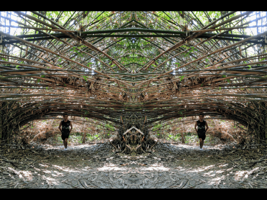
An area surrounded with bamboos, a few bunches bending over, creating tunnel-like openings. With the right camera angle, body position, plus mirrored effect, you can easily create a two-eye image.
Yellow Rock
GPS coordination (approx): 3.15628, 101.63491
A huge rock sitting on a trail, covered in moss. The color of the moss could change from different shades of green, yellow, or even brown, depending on their growth season / weather.
Angkor Wat Tree
Google Map Location: Angkor Wat Tree
GPS coordination: 3.15591, 101.63388
The tree on a rock covered with strangle figs, similar to the famous Angkor Wat temple, hence the name given by hikers.
Starbuck Corner
Google Map Location: Secret Garden
A popular spot for hikers to take a break and have a cuppa.
Serenity Tree
Google Map Location: Serenity Bamboo Stop
There is a rest hut and a nice stream beside the Serenity Tree.
Pencala Tunnel
GPS coordination: 3.164184, 101.638782
The iconic view at one of the opening ends of Pencala Tunnel. Some trails of Kiara Hill (such as Janie’s Addiction trail) walks over the tunnel, though you would not notice or feel the vehicles driving pass under your feet.
How to get to Pencala Tunnel
Enter the trail by the side of the Serenity tree.
Follow the trail until you have to walk over a drain. Climb down the drain and you will reach Pencala Tunnel viewpoint.
Great Canyon
GPS coordination: 3.165791, 101.639034
This area is South of Kiaramas Trailhead. To reach here, you can take the split road before exiting the trail via Kiaramas. Instead of going straight ahead (or the left path) to Kiaramas exit, take the path on the right and it will lead you the the Great Canyon. There is also a small path from the start of Kiaramas trail, though less visible, on the left near the abandoned car, leading to the Great Canyon.
Kiara Hill Hiking Gallery
Kiara Hill Hiking: Reader's Gallery
Want to share your photos to other readers or visitors of MeowtainPeople? Feel free to send your photo submission to jenn@meowtainpeople.com, along with contributor name (optional) and description (if any), and you might see your masterpiece here!
Epilogue
Kiara Hill remains as one of the most popular hiking spots, thanks to its vast area to explore in the middle of a city. Kiara Hill is also a very revisitable hiking location due to the many alternative paths. I also love how the same paths would always give random new encounters (flora & fauna) every time I revisit them. While hiking in Kiara Hill is considered easy, it is advisable for newbies to bring along someone who knows the area. The many split trails make it easy to lose track and difficult to backtrack, though you can always ask around. Another very useful way is to use mobile apps like Viewranger, where most of the Kiara main trails are shown on the map.
Have this guide helped you? Tag @meowtainpeople in your hiking stories & posts!
Affiliate Links to support this site:
Yay for transparency!: The links above are affiliate links, and at no additional cost to you, I earn a commission if you make a booking/purchase after clicking the links. I recommend only products and companies I use. Your support helps me keep the site going 🙂
Want to do the same affiliate marketing with your site? Use this AccessTrade platform link to receive RM5 reward.
*Captain Planet passing by* Remember, please take care of our environment, and please don’t destroy the Nature. Leave no trash behind and take back only photos and memories (and also some trash if you can). Walk on the designated path and stay in the middle as much as you can, so that the exposed soil doesn’t spread/corrode further. BE ONE WITH NATURE *flies away*


