
When one talks about hiking in Setia Alam, the three things that always come into mind are: Setia Alam Community Trail, Bukit Sapu Tangan, and of course, the Mirror Lake that has gone viral. In this post, we will explore Setia Alam Community Trail, and the paths to reach both Bukit Sapu Tangan and the Mirror Lake.
Setia Alam Community Forest (SACF)
SACF is a selectively logged lowland rainforest. It is a part of the Bukit Cherakah Forest Reserve, and home to the endangered Malayan Tapirs. Despite all these, the Bukit Cherakah Forest Reserve is pretty much at great risk of degazettement.
The Setia Alam Community Trails were initially built by the mountain bikers community, which rapidly gained popularity among hikers.
Setia Alam Community Trail - Where to park your car
During weekends, you would observe many cars parking around the Setia Alam Community Trailhead. However, the area around the main trailhead is not intended to be a parking area. It is also very common for the authorities to do checks around the area and give summons to the cars parking there. You should park your vehicle around Restoran Syed Al Habibi or 7-Eleven @ Setia Taipan, which provide plenty of legal parkings. Do remember to pay for the parking if you are visiting on weekdays. Free parking on weekends and public holidays.
Quick jump to:
Lake Trail -> Kurma Trail & Loose Rock -> The Wall -> Station B (Bukit Mesian) -> Mirror Lake -> Bukit Sapu Tangan -> Station A -> Station B1 -> Long Station C
Setia Alam Community Trail
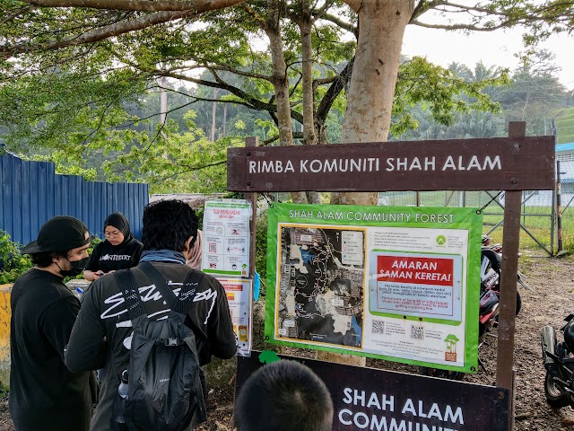
This is the main trailhead for Setia Alam Community Trail. There was a map there for your reference, but it only showed the SACF trail. Below I will guide you on how to get to Bukit Sapu Tangan and the Mirror Lake from here.

8.06am: The starting trail looks like this when you enter the trailhead.

Take the path on the right to reach the Lake Trail / Peak Garden junction.

(+2)8.08am: When you reach the junction, there are two signboards near the ground. One goes to the Lake Trail, another goes to Peak Garden. Not to get misled by these signboards though, as the ‘Lake Trail’ refers to the SACF Lake, not the famous Mirror Lake (which is nearer by taking the path on the right). The ‘Peak Garden’ is also actually nearer by taking the path on the left.

Just looking at this map, you will get a clearer picture on the trails. Circled in yellow is where you would start from the main trailhead, at the junction.

(+1)8.11am: Although my main destination is Bukit Sapu Tangan and Mirror Lake, I followed the path to the left for a longer route, looping through Kurma trail and ‘The Wall’.

(+1)8.12am: Since I was on this trail, I took a detour to the Lake Trail on the right. It is a short trail with a dead end, so I would return to this point and continue on to ‘B’ area.
Setia Alam Community Forest - Lake Trail


8.12am: Right away you would notice the Lake Trail is nice and dim. The narrow trail moves along the side of the lake.


(+4)8.16am: Along the trail, a few spots provide a good view of the calm lake.

(+12)8.28am: After reaching the end and returning to the main path, I noticed a spot along the way to ‘B’ area, where you could enjoy the lake view without having to go into the Lake Trail.


(+2)8.30am: Continue on to ‘B’ area.
Setia Alam Community Forest - Kurma Trail & Loose Rock

(+10)8.40am: Temporarily follow this signage to ‘Peak Garden’.

(+3)8.43am: The stretch along Kurma trail is flat and shady.


(+5)8.48am: At the Loose Rock trail, it is a short 2-minute uphill climb.

(+2)8.50am: At the top of Loose Rock, take the trail on the right to reach ‘The Wall’, towards Mirror Lake and Bukit Sapu Tangan. If you want to explore more of SACF instead, you can take the trail on the left to ‘Rock Garden’ trail to Peak Garden (actual name: Bukit Pasir – 226m, aka. North Hammock).
Setia Alam Community Forest - The Wall

(+8)8.58am: Here is ‘The Wall’, which is a stretch of unshaded path by the side of a deforested area for housing development. It is better to come here early in the morning, rather than during the hot afternoon.

This is the view from ‘The Wall’.


Some bunch of tangled-like pods on a tree along the way.

(+8)9.06am: At the Southern end of ‘The Wall’, you can see this hill called Bukit Binjai. The peak was further out at 197 meters, but was already leveled off by the developer.

(+1)9.07am: Re-entering the shady trails at the Southern end of ‘The Wall’ to the Mirror Lake and Bukit Sapu Tangan.
Setia Alam Community Forest Trail to Mirror Lake & Bukit Sapu Tangan


(+3)9.10am: There were signages along the way so it wasn’t difficult to navigate. The trail was pretty easy so far.
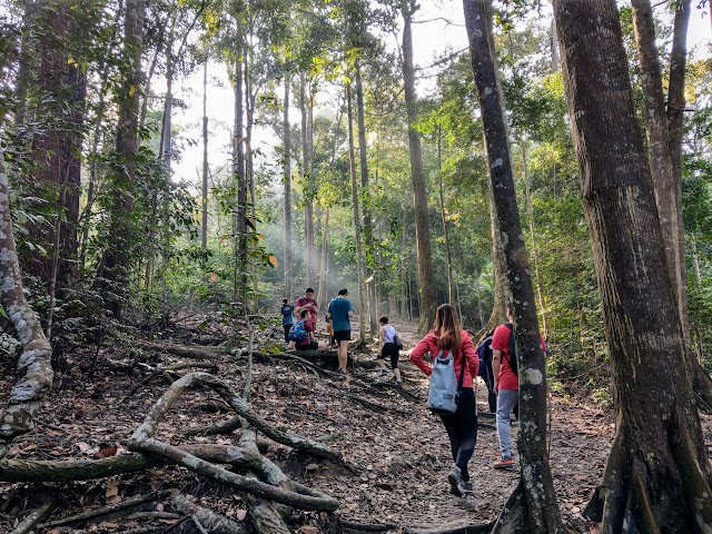

(+11)9.21am: Passing by this wide forest area with beautiful sun rays. Spend some time to rest and take photos here.

(+12)9.33am: After a break, I continued the journey and climbed toward Station B.
Bukit Mesian - Setia Alam Station B

(+9)9.43am: Here is the peak of Bukit Mesian, widely known as Station B.


Station B is a junction point with many paths. Just look around the many signages to know which direction to go next.

(+4)9.47am: I took the path to the Mirror Lake. It is a steep downhill all the way from Station B peak.
Setia Alam Mirror Lake

(+20)10.07am: When I finally reached the Mirror Lake, I was surprised by the size of the crowd!

With people swimming in the lake, don’t expect to see the ‘mirror’ effect on the lake. You can try your luck coming here on weekdays. For a similar or even better mirror lake view, I highly recommend the lake near Bukit Kembara!


Mirror Lake to Bukit Sapu Tangan


10.25am: After hanging around the Mirror Lake for awhile, I continued my journey to Bukit Sapu Tangan. I took the direct but steep path, which can be seen near the entrance trail to Mirror Lake.

(+7)10.32am: Uphill all the way from the Mirror Lake.

(+2)10.34am: At a junction, take the path on the right (a signage showing to Station A).


(+8)10.42am: This path is much steeper and more slippery, compared to the direct path between Station B and Bukit Sapu Tangan.
Bukit Sapu Tangan - Handkerchief Hill

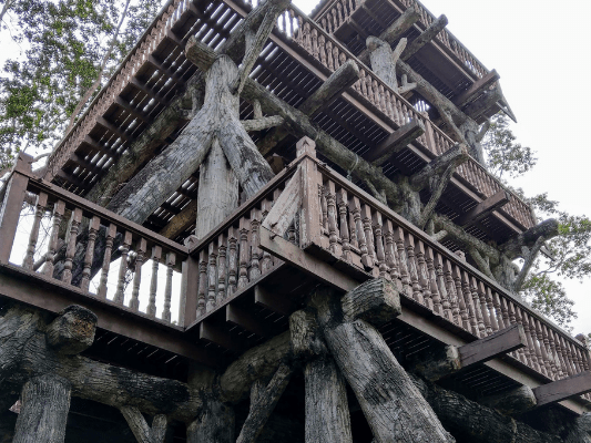
(+11)10.53am: After pushing through the steep climb, I reached the peak of Bukit Sapu Tangan – 204 meters / 669 feet.


This tower on Bukit Sapu Tangan is the highlight here. Unfortunately, the project of building this tower was never complete. The structure was nicely built, yet there are no stairs to go up to the tower.


10.59am: It’s time to head back. This time, I used the easier path back to Station B.

(+1)11am: Just walk the tarmac road from Bukit Sapu Tangan tower for a minute. Then, you will reach a T-junction.

On the left, is the tarmac path to Shah Alam National Botanical Park. Some people would take the trails from the botanical park to Bukit Sapu Tangan and the Mirror Lake, as it is easier compared to coming from Setia Alam trails.

On the right, is to re-enter the forest trail to Station B and back to Setia Alam, which is where I’ll be going.


(+1)11.01am: The trail was clear and pretty well marked.
Station A

(+10)11.11am: Reaching Station A rest area.

Complete signages to guide you where to go.
Station B1

(+10)11.21am: Reaching Station B1 rest area. This is different from Station B.

My initial plan was to follow the easier way back through Station B, but a random hiker invited me to follow her through Long Station C. Well, why not?

The Long Station C trail is a little longer than the trail to Station B. The trail is slightly more slippery as it is covered by more leaves but it was still very clear to navigate.
Long Station C

(+5)11.27am: Passing by this mini rest area. I guess this is where Long Station C is?


The trail via Long Station C is a little bit of up and down, but nothing too difficult.

(+6)11.43am: Saw this on the way, a signboard to ‘The Wall’.
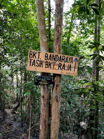
(+1)11.44am: There is also a junction to exit to Bukit Bandaraya and Tasik Bukit Raja.

(+34)12.18pm: At the junction between ‘M.O.U’ trail and ‘The Wall’, take the path on the left and you’ll be on your way back to Setia Alam Community trailhead. I left the trail at around 12.35pm.
Have this guide helped you? Tag @meowtainpeople in your hiking stories & posts!
Affiliate Links to support this site:
Yay for transparency!: The links above are affiliate links, and at no additional cost to you, I earn a commission if you make a booking/purchase after clicking the links. I recommend only products and companies I use. Your support helps me keep the site going 🙂
Want to do the same affiliate marketing with your site? Use this AccessTrade platform link to receive RM5 reward.

*Captain Planet passing by* Remember, please take care of our environment, and please don’t destroy the Nature. Leave no trash behind and take back only photos and memories (and also some trash if you can). Walk on the designated path and stay in the middle as much as you can, so that the exposed soil doesn’t spread/corrode further. BE ONE WITH NATURE *flies away*
Thank you for the detailed explanation. Really appreciate it.
I’m glad you find this guide helpful, Jules! ^^