Crossing between Bukit Sri Bintang and Bukit Kiara
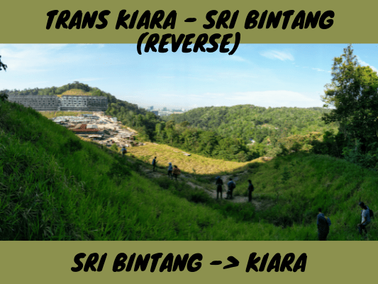
Long ago, Sri Bintang Hill used to be a part of the forest with Kiara Hill. It was then separated by the North-South Expressway flyover. Nevertheless, hiking activities to cross between these two areas are still very much doable. In fact, Trans Bintang Kiara trails have been regaining its popularity in recent years.
Trans Sri Bintang - Kiara Hiking Guide
The common entry or starting points are via Bukit Kiara or Bukit Sri Bintang Peak 2. For the following guide, we will start from Sri Bintang Peak 2 to Kiara Hill. It is the same if you start from Kiara Hill, except the order will be reversed.
Starting Point: Sri Bintang Peak 2
Hike up to the second peak of Sri Bintang Hill. Never been there? Check out Sri Bintang Hiking Guide.
Find the ‘Wisdom Tree’ on peak 2 and head to its West direction. You will find a trail at the back.
This trail will lead you down the hill to the other side.
You will walk past this tree swing.
You will then walk down this stretch of open grassy trail towards the signboards.
Under The Bridge (Highway Flyover)
Follow the trail and go underneath the signboard.
You will see the flyover there, which is the North South Expressway.
Walk down the slope to the first level (not all the way down), then walk under the bridge.
It is a nice spot to do some concrete photography under the highway.
Crime scene 1: Stolen and looted motorbike under the bridge.
Crime scene 2: (Somewhere off-trail before the highway) Stolen and pried safe box.
Cross under the bridge to the opposite site of the highway, over the small drain.
IMPORTANT: At the first junction, take the turn on the first left. Many hikers took the straight path, which is wrong and will lead to the squatter houses.
After that, just follow the trails with ribbons tied along the way.
You may encounter several split paths. As a rule of thumb, take the path with most ribbons or trail markings. Head South in general, although at some parts you may find yourself heading East for a little while.
You are on the right track if you pass through this stream. A wrong turn may bring you to the Upper/East direction of the stream. In that case, just follow the short path down the drainage to this stream.
[Sidetrack] If you walk up stream through the drainage from the stream, you will reach this tunnel. It is a shortcut to cross to the other side of the highway to Sri Bintang Hill.
[Back to the stream] After crossing the stream, follow the narrow trail with some incline.
More split paths. As usual, follow the one with more ribbons or markings.
[Accidental find] One of the wrong split paths brought us to this beautiful tree.
Thunder Valley Trail
Walk past some rocks and then a little bit of downhill.
At this point, if you use ViewRanger app, you’ll find yourself on a trail named ‘Thunder Valley’. It is then easy to follow the trail map to the construction area to the South.
Some organisms we stumbled across.
A flower pod or seed that looks like the headcrab in the Half-Life video game series.
I thought this was a pile of tangled string but then it started crawling and jumping! This is actually a planthopper nymph.
Some pretty plants.
Construction Site
Moving South along Thunder Valley trail, you will eventually reach the sad sight of a housing development group.
That hill over there behind the houses is the Look out point Bkt Kiara, which we are heading to after this.
We need to move through the side of the construction site (West; on the right side from our direction).
Head down the slope to the side of the construction site. Notice there is a shaded trailhead there, that is the trailhead to Kiara Hill.
Enter the trailhead to Bukit Kiara.
Mosquito Attack! This was where the mosquito mayhem began, all the way along the ‘Clenched Sphincter’ trail. (Yup, what a weird name for a trail. More weird and raunchy trail names ahead!)
This slope by the side of the developing houses is steep with areas of loose soil. Take extra precautions.
Once you reach the top, you have to go down again on the other side.
Big Boulders Valley
Walk down the slope by the side of this hut and the tall tree. You will then notice a pile of big boulders at the valley on your left.
The big rocks at the bottom of the valley.
Walk past to the other side of the rocks to continue the trail towards Bukit Kiara.
It was quite bushy and it is going uphill again.
Oh, and I won’t forget to mention again, the swarms of mosquitos here are fierce!
Back to the more ‘forest-like’ trail.
At the junction with some makeshift shelters, turn right and follow the trail.
Clenched Sphincter Trail
You will find yourself at the Clenched Sphincter trail heading South, toward Janie’s Addiction Trail or Boner Trail that leads to Kiara Hill. You can also head East to Boner Trail to exit the trail at Bukit Kiara Via Kiaramas trailhead. I tried to find the Vaginal Trail but did not manage to find it. It is probably covered by overgrowns and no longer exists. (Who named these trails by the way? Haha!)
On Clenched Sphincter trail you will pass by this huge rock.
And then uphill to the Bukit Kiara Lookout Point.
Kiara Hill Lookout Point
We are now at Bukit Kiara Lookout Point, on the peak we saw on the other side of the construction site when coming from Bukit Sri Bintang.
Imagine the view if the forest is not cleared for this housing development…
Anyway, we continued on the Clenched Sphincter trail, to the connection point with Boner Trail and Janie’s Addiction. Before reaching the connection point, you may notice other junctions such as the ‘MET1’. To go to Kiara Hill, you should head South and take Janie’s Addiction trail. Before that, let us sidetrack to Boner trail to show you the exits.
Boner Trail [sidetrack]
Walking along the Boner trail, you will reach a cross junction. Take the left junction to Kiaramas exit.
Take the main path in the middle to exit to Kiaramas trailhead.
Here is the Kiaramas trailhead with an abandoned car.
Outside view of Kiaramas trailhead beside Ayuria Condominium. Location map: Bukit Kiara via Kiaramas
This is the “Great Canyon” if you take that path at the junction as shown above (orange color arrow).
Janie’s Addiction Trail
Continuing on the Trans Sri Bintang to Kiara route, following Janie’s Addiction Trail. This would be a straight forward walk toward the South.
There is a rest area called Bamboo Stop along Janie’s Addiction Trail. You may miss it as there are two parallel trails heading South, before joining back as one. The Bamboo Stop is very near the joining trails, so if you find yourself at the one without the stop, just make a u-turn at the joining paths and it’s there within a few meters.
Go all the way South and your path will be blocked by this gate that is always locked.
Worry not, just follow the side and you will find this ‘unofficial opening’. Then, just walk back to the gate area and continue South.
You are at the main Kiara Hill area now. There are many trails here, but if you want to head to the peak, walk South and then take the first trail to the left.
You will then reach Twin Peaks Rest Stop.
Bukit Kiara Peak
Here is the peak of Kiara Hill, at 258 meters / 846 feet. There are multiple points of interest around here, you can refer to my other post about Bukit Kiara.
Trans Kiara Bintang - Back to Sri Bintang Hill from Bukit Kiara:
Have this guide helped you? Tag @meowtainpeople in your hiking stories & posts!
Affiliate Links to support this site:
Yay for transparency!: The links above are affiliate links, and at no additional cost to you, I earn a commission if you make a booking/purchase after clicking the links. I recommend only products and companies I use. Your support helps me keep the site going 🙂
Want to do the same affiliate marketing with your site? Use this AccessTrade platform link to receive RM5 reward.
*Captain Planet passing by* Remember, please take care of our environment, and please don’t destroy the Nature. Leave no trash behind and take back only photos and memories (and also some trash if you can). Walk on the designated path and stay in the middle as much as you can, so that the exposed soil doesn’t spread/corrode further. BE ONE WITH NATURE *flies away*


Sorry please delete my first comment, I meant the upward slope towards the highway, not clenched sphincter trail. The photo with the mosquito mayhem area has landslide, making it no possible to go through now. Mosque guy from Jalan palimbayan will block people from entering if there is an attempt from that entry. I came out from there after gave up.
Oh I see, thank you so much for letting us know! I shall add in a notice box in the post.