
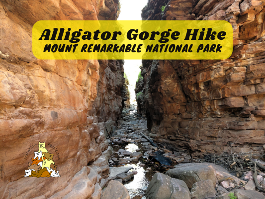
Alligator Gorge is one of the top natural wonders to see in Mount Remarkable National Park. It features dramatic gorges with tall and narrow rock walls. You can access Alligator Gorge by doing the shorter, 2km return Narrows Hike from the car park. There are also longer hikes you can do, such as a 8.5km return hike, or a 8.9km loop called the Alligator Gorge Ring Route.
Vehicle entry fee into Mount Remarkable National Park applies and online payment is required, but it’s waived on the day you book a stay at the campground.

You can download the free map from Avenza Maps to navigate and track your location.
In this post, we will explore the trails from the Northern entry (via Wilmington) of Mount Remarkable National Park. Check out my other post to explore the Hidden Gorge and other trails from the Western entry of Mount Remarkable National Park.
Alligator Gorge Ring Route Hiking Trailhead & Car Parks

Most people park their vehicles at the main Alligator Gorge car park. However, since I am doing the ring route, I decided to park at the Bluegum Flat Picnic Area, as the loop starts and ends here.


10.26am: Doing it in an anti-clockwise direction, I entered the trailhead to The Narrows.


Wildflowers bloom in abundance in spring.

(+9)10.35am: Soon you’ll reach a creek before entering the gorge.

(+2)10.37am: Follow the trail through the gorge.


(+1)10.38am: Spend some time to admire the rock walls as you pass through Alligator Gorge. Featuring: Cappy the capybara.


(+2)10.40am: Entering ‘The Narrows’.
The Narrows


(+4)10.44am


(+6)10.50am: Here is the narrowest section of Alligator Gorge / The Narrows.


(+1)10.51am: It’s wide enough for a few people to walk side-by-side. The water level is higher during the wet months of winter and spring, so you might need to walk on the rocks or wet your feet.


(+1)10.52am

(+1)10.53am: Out of the narrowest section and looking back.

(+6)10.59am
Alligator Gorge Hike


(+4)11.03am: At the junction to continue towards Alligator Gorge Hike.
The Terraces


(+5)11.08am: Arrived at The Terraces. It is a natural cascading rock formation that looks like a paved path with stairs. There was some water flowing down the natural staircase and you can find ancient ripple marks here.


(+9)11.17am


On the trail, I encountered some wildlife, including a snake (probably a venomous brown snake). So, watch where you step!

(+4)11.21am: More gorges.

(+1)11.22am

A skeleton in the creek. I wonder what animal this is…

(+2)11.24am

(+1)11.25am

(+3)11.28am

(+30)11.58am: Near the Northern tip of the trail (before the half-way point), the path goes uphill on the rock stairs.


Along this section, there were many of these fire-charred austral grass trees. These are iconic fire-resistant plants in Australia. They are exceptionally slow growing but can live for centuries. Their fire-blackened trunks are formed by old leaves into skirts that protect the plants’ core from bushfires.

(+3)12.01pm

(+13)12.14pm: Next, the trail becomes a fire track as you continue the hike Southwards.

(+6)12.20pm: Passing by Eaglehawk Camp, which was closed due to the 2025 Wilmington bushfire.

A goanna.

(+9)12.29pm: It’s a gentle downhill on the fire track.

(+31)1pm: Passing by Longhill Camp, which was also closed due to the bushfire.

(+1)1.01pm: I arrived at the car park at 1.07pm
Gorge Lookout Walk


1.22pm: Stopping by at the main Alligator Gorge car park, I went for the short walk to Alligator Gorge Lookout. Ali Lookout Walk also starts from this car park, but the trail was still closed due to the Wilmington bushfire.

(+5)1.27pm: It’s a 5-minute hike to the lookout at the top of the gorge, overlooking the other side of Alligator Gorge rock wall.
帖子有帮到您吗?在您的登山故事和帖子中标记 @meowtainpeople 吧!

*地球队长经过* 记住,请保护我们的环境,请勿破坏大自然。不要留下任何垃圾,只带回照片和回忆(如果可以的话,还可以捡走一些垃圾)。请在指定的路径上行走,并尽量保持在中间行走,以使裸露的土壤不会进一步扩散/腐蚀。与大自然融为一体吧 *飞走了*

支持本网站的附属链接:
透明度万岁!:以上链接是会员链接,如果您用此链接购买或预订的话,我可以赚取佣金, 而你也不会被收取额外费用。 我只推荐我使用的产品和公司。您的支持可以帮助我保持网站的运行,让我继续用心分享🙂
想在您的网站进行相同的联属网络营销吗?用这个 AccessTrade 平台链接 获取 RM5 奖励。