
Mount Remarkable National Park is a truly ‘remarkable’ place to soak in the natural beauty of rugged South Australia. There are multiple starting points or ‘parts’ in Mount Remarkable National Park, and in this post we will explore the hikes from Mambray Creek section. The hikes covered in this post include: Hidden Gorge Hike, Daveys Gully Hike, Wira Water Loop and Baroota Hike.
Vehicle entry fee into Mount Remarkable National Park applies and online payment is required, but it’s waived on the day you book a stay at the campground.

You can download the free map from Avenza Maps to navigate and track your location.
In this post, we will explore the trails from the Western entry (Mambray Creek) of Mount Remarkable National Park. Check out my other post to explore the Alligator Gorge from the Northern entry of Mount Remarkable National Park.
Camping in Mount Remarkable National Park
The two main drive-in campgrounds in Mount Remarkable National Park are Baroota Ruins Campground 和 Mambray Creek Campground, which can be booked online.
There are also 11 hike-in campsites and two large group campgrounds that can be booked through National Parks and Wildlife Service, Yorke and Mid North Office on +61 8 8841 3400.
Baroota Ruins Campground

Baroota Ruins Campground is a smaller campground with 9 camping sites with fire pits and a long-drop toilet. I stayed here on the first night while I explored the short trails of Wira Water Loop and Baroota Hike, before the main hike at Hidden Gorge the next morning.


Baroota Ruins Campground suits campers who value a more quiet, minimalist campsite. In the evening, I saw kangaroos and emus roaming close to the campground.
Mambray Creek Campground


In contrast, Mambray Creek Campground is a larger campground with 49 campsites with modern facilities, such as hot showers, flush toilets, potable tap water and gas BBQs. I stayed here on the second night after Hidden Gorge Hike, and explored Daveys Gully Hike in the evening.


A seasonal stream flows next to the campground. On the opposite side of the stream is a tall rocky wall that is part of the Battery Ridge.


Kangaroos can be spotted chilling around the campground.


There seemed to be a goanna (monitor lizard) that resides on this spot, climbing the big tree or sunbathing on the log during the day, and sleeping in the hollow log at night.
Wirra Water Loop & Baroota Hike

Wirra Water Loop is an easy 800-meter (one way) hike with a little loop at the end, while Baroota Hike uses the same trail with another 2.2km extension to the Baroota ruins and cemetery. In total, it’s a 6km return loop and you can start from Mambray Creek Campground and Day Visitor Area, or from Baroota Ruins Campground.


Plenty of wildflowers bloom in spring.


Kangaroos in the area.


Through the Wirra Water Loop, you’ll pass underneath some river red gum trees with a wide hollow base, some seemingly split in half. These river red gums have their trunks hollowed out by fire and termites, their heartwood gone. Remarkably, these trees are very much alive and have healthy canopies.
The bark encrusted lump on the river red gums are called burls. Burls develop when living tissue is damaged by insects or other physical impacts. They grow around the damaged areas to contain it. Some burls keep growing and become massive, but they don’t affect the tree’s overall health.


Wood grubs chewed their way through the trunk’s living tissue, leaving patterns that remain long after they left.

A goanna climbing a tree.

Baroota Cemetery: Mortality rates of early settlers were high, as medical help wasn’t readily available. People were often buried in unmarked graves near to where they died. There are more graves in Baroota Cemetery than are marked, but there’s no record of the exact numbers or names.


You’ll pass through the middle of the campground and cross the road to the Baroota Ruins.
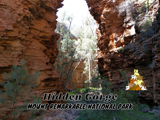
Hidden Gorge Hike


8.22am: Starting the Hidden Gorge Hike from the trailhead near Mambray Creek Day Visitor Area. There are a couple of sections where the creek flows over the main path, but there are always alternative trails at the side (with the ‘creek crossing’ signs) you can use if the water level is too high (seasonal).

(+8)8.30am

(+3)8.33am: Walk along the main trail until the first junction. Here I took the left turn as I was doing the hike clockwise.

This is the path straight ahead that you can take if you are doing it anti-clockwise, but that’s where I’ll return from.

(+1)8.34am: Turning left and hiking clockwise will lead you to ascend up a ridge that gradually ascends and connects with Battery Ridge (around 5km and 400m total elevation).

(+27)9.01am

(+8)9.09am

(+28)9.37am

(+0)9.37am: Wide views of the land and sea (Spencer Gulf) as you gradually ascend along the ridge.

(+20)9.57am: Here is the junction as you arrive at the Battery Ridge Track. Turn right to continue the Hidden Gorge Hike.

The track on Battery Ridge is wide as it serves as a fire track for firefighting vehicles.

(+9)10.06am: After a short walk on Battery Ridge Track you will arrive at the first of the two water tanks. This is the higher point of Hidden Gorge Hike (574m) and the rest of the hike is mostly gentle downhill (plus walking over rocks at the narrow Hidden Gorge). Fill up your water (filter or boil it) if required. P.S. Water availability is not guaranteed, as the rainwater collection tanks may dry out, especially during the summer and autumn months.

Next to the water tank is the turn-off trail to continue the Hidden Gorge Hike.

10.16am: After a short water break at the water tank, I continued my hike.

(+7)10.40am
Hidden Gorge

(+9)10.49am: Eventually, you’ll find yourself flanked by the rocky cliffs walls as the trail descends down into Hidden Gorge.


Water along the path in Hidden Gorge. I did this hike in early spring, so the water was considered plentiful after the wet winter season. This meant there was quite a lot of walking/climbing over rocks to avoid the water. Also, there were many big tadpoles swimming in the water.


(+7)10.56am: Magnificent rocky walls.


(+10)11.06am

(+9)11.15am


(+7)11.22am


(+5)11.27am: At the narrowest part of Hidden Gorge, where I had to climb over some rubble to the other side.

(+1)11.28am

(+9)11.37am


(+7)11.44am: Another narrow point, but the path was clear for this one.

(+20)12.04pm

(+5)12.09pm: Arrived at the junction near Hidden Camp. Turn right to continue the Hidden Gorge Hike back towards Mambray Creek.


(+5)12.09pm: Flat hiking trail through the pine flat with a tall rock wall at one side.


(+10)12.19pm: Crossing a creek by stepping on rocks.

(+37)12.56pm

(+15)1.11pm

(+9)1.20pm

(+2)1.22pm: The junction near Scarfes Hut, turn right to continue the hike towards the car park.


(+23)1.45pm: A path overflowed with creek water. You can backtrack a bit and take the creek crossing dry trail. I completed my hike back at the car park at 2.09pm.
Daveys Gully Hike

4.36pm: Daveys Gully Hike is a short hiking loop right next to Mambray Creek Campground and the day visitor parking area. You can hike the trail either in a clockwise or anti-clockwise direction. The photo above is the anti-clockwise trailhead just across the road from the parking area.

(+3)4.39pm: The anti-clockwise direction is the shorter path up the hill to the sunset viewing area. A small drawback walking in this direction is that the sun would be glaring at your eyes.

Looking back you can see the gorge’s rock wall formations close to the campground.


(+10)4.49pm: Half way to the top is a little platform where you can also view the sunset if you don’t want to go further.

I encountered a little noodle on the trail. At first, I thought it could be a baby snake. Later, thanks to Snake Identification Australia Facebook group, it was revealed to be a legless common scaly-foot lizard (shout out to Yarni for the identification!)

(+5)4.54pm: Arrived at the highest point of Daveys Gully Hike. There is a bench here for viewing the scenery.

I arrived too early with the sun still high.

So, I continued the loop all the way to the other end of the trailhead, before coming back up using the clockwise direction for the sunset.

Going down on this side is pretty chill and easy.

A laughing kookaburra on the tree.

Also, I encountered a few big emus on the way down the hill!

(+27)5.21pm: Arrived at the other end’s trailhead.


Here is the trailhead for the clockwise direction. Follow the main trail for the other hikes and you’ll see the turn-off to Daveys Gully Hike. I will now head back up from where I came.

(+2)5.23pm: This was where I encountered the emus.

(+6)5.29pm: I recommend doing this in a clockwise direction, as the setting sun is blocked by the hills.


(+9)5.38pm

(+6)5.44pm: Back to the sunset viewing area.

5.56pm: If you are staying at Mambray Creek Campground, sunset watching at Daveys Gully Hike is a top thing to do!


On the way back down, I encountered a kangaroo mama with a joey in her pouch!

Next day, I left Mount Remarkable National Park and on the way back towards Adelaide, I stopped by at Harry’s Homemade Fine Foods for camel burger and camel milk.
帖子有帮到您吗?在您的登山故事和帖子中标记 @meowtainpeople 吧!

*地球队长经过* 记住,请保护我们的环境,请勿破坏大自然。不要留下任何垃圾,只带回照片和回忆(如果可以的话,还可以捡走一些垃圾)。请在指定的路径上行走,并尽量保持在中间行走,以使裸露的土壤不会进一步扩散/腐蚀。与大自然融为一体吧 *飞走了*
支持本网站的附属链接:
透明度万岁!:以上链接是会员链接,如果您用此链接购买或预订的话,我可以赚取佣金, 而你也不会被收取额外费用。 我只推荐我使用的产品和公司。您的支持可以帮助我保持网站的运行,让我继续用心分享🙂
想在您的网站进行相同的联属网络营销吗?用这个 AccessTrade 平台链接 获取 RM5 奖励。