
Lambir Hills National Park: Latak to Pantu Trails
Situated around 30+km from Miri, Lambir Hills National Park is a 40 minutes drive from the town. In this post, we will go through the most common trails: the first half segment, which are the trails to Latak Waterfall, Nibong Waterfall, Bukit Pantu and Pantu Waterfall.
How to get to Lambir Hills National Park by Bus

- Head over to Terminal Bas Pujut (also known as Miri Bus Terminal). You can get to this bus stop by taxi / through e-hailing platforms such as Grab and Maxim (Maxim is more popular than Grab in Miri due to the slightly cheaper price), or you could take a public bus that passes by Boulevard Shopping Complex and drop off near the complex and walk 10 minutes to the terminal.
- Buy an express bus ticket from the terminal counter. Tell the staff you would like to visit Lambir Hills National Park and they will give you the Miri-Bintulu express ticket for RM10.
- In the bus, inform the driver of your destination and the driver will stop opposite of the Lambir Hills National Park entrance for you to drop off. (You have to let the driver know your destination because the national park is not an official stop for the express bus. Even though it is an express bus, you can occasionally see people getting on and off from the bus midway.) The journey will take around an hour.
- To head back to town from the national park, you have to wait for the express bus at the park entrance side of the road (opposite of where you drop off). Just signal the bus and it will stop to pick you up (RM10 back to the terminal). I am not sure what time the last bus will drop by but try not to leave later than 5.30pm. Anyway, you have to finish your hike in the national park by 4pm so it shouldn’t be an issue.
Lambir Hills National Park

Operation Hours
Daily:
Administrative Office: 8am – 5pm
Registration Counter: 8am – 3pm
Outdoor Activities: 8am – 4pm
Tel: +6085 471 609 / +6085 471 630 (8am – 5pm)
*All visitors are advised to leave the forest by 4pm.
Entrance Fees
Category | Malaysian (RM) | Non Malaysian (RM) |
Adult | 10.00 | 20.00 |
Senior Citizen | 5.00 | – |
Disabled | 5.00 | – |
Student (>6 ≤18) | 3.00 | 7.00 |
Children (≤6) | Free | Free |
Quick Walkthrough
View trail map here. This map will be given when you purchase the ticket by the counter.
12.16pm: Entrance
12.32pm: Latak Waterfall
1.03pm: Nibong Waterfall
2.07pm: Bukit Pantu
3.19pm: Pantu Waterfall
4.02pm: Exit
Detailed Walkthrough
View trail map here. This map will be given when you purchase the ticket by the counter.
The trails are well marked with different colors for each trail painted on the trees.
Trail to Latak Waterfall

12.16pm: Enter the main trail entrance located near the ticket counter.

Just follow the red marked trail.


(+6)12.22pm: Hanging bridge crossing.


(+1)12.23pm: Right after the bridge, you’ll find Waterfall 1 at the right side of the trail. The path way to this waterfall was blocked by the fence. Continue with the red marked trail.

(+3)12.26pm: At the junction, follow the red markers and go straight ahead. We will return to this spot after coming back from Latak Waterfall.

(+0)12.26pm: Cross over the wooden bridge.

(+1)12.27pm: River below the bridge. Some strange-looking caved-in circles can be spotted.

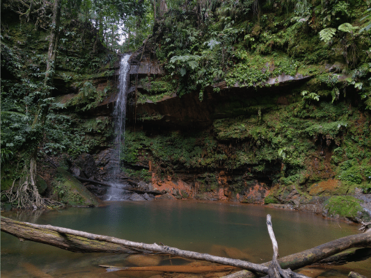
(+2)12.29pm: In a couple of minutes, you’ll reach Latak Waterfall.

(+3)12.32pm: Latak Waterfall
Trail to Nibong Waterfall


(+3)12.35pm: Head back to the junction, go up the stairs heading to Nibong Waterfall.

(+1)12.36pm: This is Lambir Hills’ version of ‘killer stairs’. Unlike Bukit Gasing’s killer stairs, this is fully made out of concrete and the distance is much shorter but will still ‘kill’ your stamina if you didn’t warm up.

(+1)12.37pm: Looking back down from the top.

(+1)12.38pm: Follow the only trail (marked with white paint).

(+1)12.39pm: A damaged tree tower at the side.

(+19)12.58pm: At the junction, go straight towards Nibong Waterfall.

(+1)12.59pm: Walk alongside the huge mossy fallen tree trunk.

(+3)1.02pm: Before reaching the waterfall, you’ll have to step over this small stream and crawl under the fallen tree trunk ahead (if the trunk is still there).


(+1)1.03pm: Nibong Waterfall: It was very small and a little anticlimactic at that time. There were also some weird foam floating on the surface.
Trail to Bukit Pantu

(+3)1.06pm: Head back to the previous junction and head up to the direction of Bukit Pantu (trail marked with white paint).

(+6)1.12pm: A little uphill climbing. (By the way, this is the trail to the 4-way intersection, which one of the paths leads to Bukit Pantu. This is not the Bukit Pantu trail itself.)

(+10)1.22pm: After a series of flat trails and gradual inclines, you’ll reach a 4-way intersection with a hut.

(+8)1.30pm: After taking some rest, follow the directional signage to Bukit Pantu(14km).


(+7)1.37pm: The path starts with slight decline and then mostly gradual incline after that.


(+19)1.56pm: Towards the last sections of Bukit Pantu trail, there are a few paths with stairs.


(+5)2.01pm: You’ll be welcomed by tall walls of the rocky surfaces at the starting of the final push to the top.

(+3)2.04pm: Final stairs

(+2)2.06pm: Final push.

(+1)2.07pm: Finally, the top base of Bukit Pantu!

There is a hut here at the top. There is also a qr code signage here (I saw a couple more at other spots) for hikers to scan and fill in a Google Form to inform that they are safe but they did it the wrong way by linking it to the editor version of the form, so form’s messed up.


Clear views from the top.

(+56)3.03pm: After taking a 15 minutes break, it took me around 40 minutes to walk back down to the 4-way intersection.
Trail to Pantu Waterfall

(+3)3.06pm: After taking a 3 minutes break at the hut, I headed toward Pantu Waterfall.

(+4)3.10pm: Slight downhill most of the time.

(+2)3.12pm: Turn left at the junction to Pantu Waterfall. More downhill. (The long path ahead leads to many more places such as the oil well, Bukit Lambir and three waterfalls. I did not manage to explore those area due to the time. I started the hike later and hikers have to leave the forest by 4pm.)

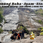
(+6)3.18pm: Pantu Waterfall just ahead.

(+1)3.19pm: Pantu Waterfall
Trail back to Park HQ

(+11)3.30pm: Head back to the 4-way intersection and follow the direction to the Park HQ.

(+1)3.31pm: Similar to the other trails, it is clearly marked and easy to follow. Follow the pink marked trees back to the Park HQ. Estimated time on the map for this trail is 45minutes. I had like 30 minutes left before 4pm so I increased my pace a little.


(+20)3.51pm: This bridge indicates that you are ⅔ of the trail to exit the forest. Up ahead you’ll find a sign stating that the Park HQ is 500 meter ahead.


(+11)4.02pm: Finally, the exit. Just about time!

(+1)4.03pm: This exit is on the opposite side of the Park HQ from where I first entered the forest. Just follow the tarmac road, turn left and you’ll reach the HQ in 5-6 minutes.
Epilogue
Due to my late arrival, there wasn’t enough time for me to explore the other half of the trails. I will be coming back to finish the trails in the future, I promise 😉
For trails I have explored, all of them were well marked and straightforward. All of the junctions were placed with vital directional signages to the correct locations. No guide is needed and it was totally doable by a single hiker.
Have this guide helped you? Tag @meowtainpeople in your hiking stories & posts!

*Captain Planet passing by* Remember, please take care of our environment, and please don’t destroy the Nature. Leave no trash behind and take back only photos and memories (and also some trash if you can). Walk on the designated path and stay in the middle as much as you can, so that the exposed soil doesn’t spread/corrode further. BE ONE WITH NATURE *flies away*
Affiliate Links to support this site:
Yay for transparency!: The links above are affiliate links, and at no additional cost to you, I earn a commission if you make a booking/purchase after clicking the links. I recommend only products and companies I use. Your support helps me keep the site going 🙂
Want to do the same affiliate marketing with your site? Use this AccessTrade platform link to receive RM5 reward.
Very detailed write up. After reading about your write up, I m more eager to explore more about hiking. Is there any hiking groups in Selangor or KL that I can join?
Thanks for the comment, Lisa!
You may join Trailblazer Hiking Club Malaysia (THCM) https://www.facebook.com/groups/2458926291018484/
They actively organize weekly trips around Malaysia.