Pre-Eclipse Hike to Mount Pulai in Pekan Nanas, Johor
We visited Mount Pulai when we went to Johor on 25th December 2019 with the purpose of witnessing the annular solar-eclipse happening on the next day.
Mount Pulai could be considered as one of the most popular recreational and hiking spots in Johor, often visited by the locals and neighbours from Singapore. Standing at the height of 654 meter, it is not really considered as a mountain but more of a hill, even though it had the name of ‘Mount’ Pulai.
Nevertheless, the paths heading up to and coming back down from the highest point accessible do pose some challenging factors. You have two or more paths to choose from:
- Tarmac road: It is being used by the vehicles to reach the telecommunication building on the top. Flat but steep, I would prefer using the forest trails.
- Forest trails:
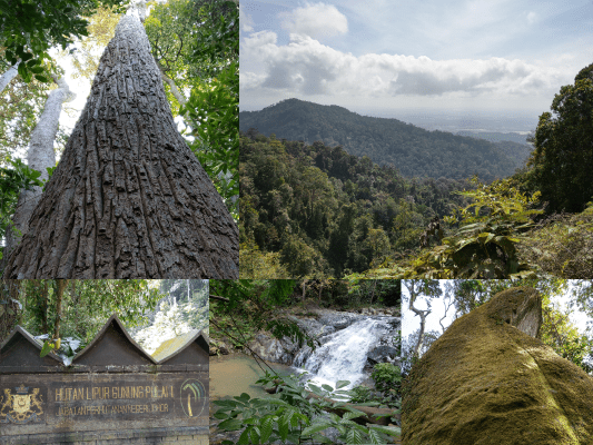
- The most common main trail has a very clear path. Starting point is at the early part of the tarmac road after the main gate with a “Hutan Pelajaran” signboard. Quite steep at some parts, while others are flat and some parts might be muddy.
- The second less common trail starts right before the main gate. The path will merge will the first one near the top. I was planning to use this path during the descent but the path seemed to be blocked by a rope.
- Sources indicate that there is a hidden third path but I did not manage to get further information on this.
Did you know?
Parts of Mount Pulai’s forest is unlogged dipterocarp rainforest. Along the trails, you could find many huge trees with very wide trunk diameter in this virgin rainforest. It also serves as the main water catchment area for Johor city and the neighbouring country of Singapore.
How to get to Mount Pulai
Enter from Gunung Pulai Recreational Forest Western Section (through Kampung Sri Gunung Pulai). An entrance fee of RM3 per car is to be paid at the entrance post.
Drive all the way to the end and find a parking spot, someone there might guide you.
Ample of parking space that will still get full during weekends and holidays.
Just down the parking area you’ll immediately see a river by the side where I saw a few people camping here.
My experience hiking Mount Pulai
Quick Walkthrough
8.41am – Entrance
9.01am – Forest Trail Starting Point
10.15am – Huge Rock
10.31am – Forest Trail Peak
10.54am – Tarmac Road Peak
11.59am – Exit
Detailed Walkthrough
Mount Pulai Hiking Entrance
8.41am: The hike started at the entrance here.
The area is closed on October to December ‘for safety reason’. The notice board also mentioned that the area is open from 8am to 6pm and close on Monday for maintenance purpose.
Update: Since the new implementation of Johor forestry rules (which is pretty stupid for simple trails), you need to hire a mountain guide to hike the forest trail (not needed if you take the tarmac road).
(+2)8.43am: The path starts with tarmac road uphill, all the way to the top but later on we will enter the forest trail from the side of the road.
(+9)8.52am: The road will branch out here. The left leads to the first level of waterfall and also the washroom facilities. We walked to the left to take a look at the waterfall.
(+2)8.54am: “Attention: Only monkeys are allowed to litter”. Good one haha!
(+1)8.55am: Just down the road, you’ll find the first waterfall (there are few more waterfalls and rivers when you walk up along the tarmac road on the right side just now).
(+3)8.58am: We walked back to the split path and took the road to the right to continue our way up.
The tarmac road up is a constant uphill.
Forest Trail Starting Point
(+3)9.01am: After walking on the tarmac road for awhile, pay attention to your right side and you’ll see this sign “Hutan Pelajaran”(Education Forest) and here is the starting point of the main forest trail. You can just continue straight ahead the tarmac road to the top but that’s kinda boring and also very tiring.
(+1)9.02am: The trail starts straight up with constant steep uphills.
On the way up, we saw some pretty interesting huge vine-like plants.
(+13)9.15am: After an exhausting steep uphill battle, we finally reached the first checkpoint with a “CP 9” sign.
(+2)9.17am: We took a two minutes rest here before continuing our trail at the back of this tree trunk.
(+1)9.18am: The trail is relatively flat from here.
Along the trail, we found quite many magnificent trees with huge trunk.
(+12)9.30am: We reached this sign “830”.
(+5)9.35am: The path gets steeper again from here. There was a spot for resting half way up the steep path.
(+7)9.42am: The path gets less steep for awhile after the resting spot.
(+9)9.51am: Then, it gets steep again.
(+13)10.04am: Here, there is a split path, just keep to the left. The right side is probably a loop, we are not so sure.
(+1)10.05am: Near by, there is a path blocked by a piece of rope, we guess this is the second less common trail that starts just before the gate, where it will join back to this main trail here.
(+2)10.07am: Just go straight, we came across a couple of fallen tree trunks on the trail.
(+1)10.08am: A split path here but it will join back together.
Huge Rock
(+5)10.13am: When you see a rock popping out at the top, it means you are very close to the famous huge rock.
The rock that you saw is this smaller rock, Behind this rock is a rest area with some DIY benches and chairs.
(+2)10.15am: Walk across the rest area and you’ll find that huge rock you’re looking for.
Legend says that Dayne “The Rock” Johnson was born here (just kidding XP)!
(+2)10.17am: We continued our journey through the path at the left side of the huge rock.
(+12)10.29am: After walking through some flat and slight steep paths, we saw the first sign of the sky clearing up and the sun shining above our head.
Forest Trail Peak
(+2)10.31am: Soon, we reached the peak of the trail.
(+1)10.32am: You could view the ocean far away from here.
(+1)10.33am: This is not the end. We continued our journey into the trail at the other side of the peak(opposite side of where we arrived from).
(+8)10.41am: The path was relatively flat. There was a split path but they will join back together. We found our first path out of the forest trail to the tarmac road but we continued on the forest trail, and stumbled upon a few more paths to exit to the tarmac road.
(+7)10.48am: Finally, there wasn’t anyone forest path to continue on and we had to exit to the tarmac road. We continued heading up.
(+3)10.51am: On the way we reach the first telecommunication tower.
You can see the other higher tower from here.
(+2)10.53am: At the right side of this tower, there is a path leading to the back end.
Tarmac Road Peak
(+1)10.54am: It leads to the tarmac road peak with a good view.
The tarmac road peak’s view.
You could see the water reservoir from here.
At the back, we saw another path heading to another forest trail, I did a quick scouting a it seemed that it’s a long path, probably leading to the far end of the forest with a different entrance. I also got to know that hikers could reach here via the Blue Lake so that would be a long walk. (One day I would come back and explore this path)
11.01am: We were heading back to the front of the first tower and saw this path up, probably leads back to another part of the tarmac road.
(+5)11.06am: We continued up the tarmac to reach the top tower but then we saw this sign, “Stop, Sampai Sini Saja”, stating that this is the furthest you can proceed. We heard someone walk further up and got shouted by the tower’s guard.
(+9)11.15am: After taking a rest, we began our dreaded journey down the tarmac road. The road was rather steep but just not steep enough to use certain walking strategies. This hurts the knees more than the forest trail.
Tip: Bent your knee more and lower your body when walking down the road, move in zig-zag pattern on steeper paths so you slow down through sideways instead of directly using the knee.
(+28)11.43am: Along the way near the bottom. We could see some waterfalls and rivers on our right side.
Exit
(+16)11.59am: After walking down what seemed like an never-ending tarmac road for 44 minutes, we finally reached the “Hutan Pelajaran” starting point of our forest trail. Time to rest our knees and have lunch before we head off to the Blue Lake and Pontian Happiness Homestay.
Epilogue
Mount Pulai is a very precious unlogged virgin forest which also acts as an important water catchment forest to supply a huge population. Let’s hope that this forest stays unlogged and untouched by urban development. There are already some quarry activities and construction going on at the other side of the hill, slowly eating off small bits of the forest. We hope that the ministry will protect the forest instead of focusing on developing the land here.
Have this guide helped you? Tag @meowtainpeople in your hiking stories & posts!
*Captain Planet passing by* Remember, please take care of our environment, and please don’t destroy the Nature. Leave no trash behind and take back only photos and memories (and also some trash if you can). Walk on the designated path and stay in the middle as much as you can, so that the exposed soil doesn’t spread/corrode further. BE ONE WITH NATURE *flies away*
Affiliate Links to support this site:
Yay for transparency!: The links above are affiliate links, and at no additional cost to you, I earn a commission if you make a booking/purchase after clicking the links. I recommend only products and companies I use. Your support helps me keep the site going 🙂
Want to do the same affiliate marketing with your site? Use this AccessTrade platform link to receive RM5 reward.


